

Conachcraig
Good walks are even better shared.
NO2786 : Tor on Conachcraig
David Maclennan Photo source
Overview
Conachcraig: A Hidden Gem in the Highlands
Nestled in the Scottish Highlands, Conachcraig stands at an elevation of 533 meters, offering hikers delightful challenges and rewarding vistas.
Geology
Conachcraig's robust geological foundation features granite and schist, sculpted by ancient glaciers that shaped the landscape we behold today. These rock formations provide not only a diverse terrain but also a glimpse into millions of years of history.
Routes and Ascent
The most popular route begins at Glen Dochart. This hike stretches approximately 11 kilometers round-trip, typically taking around 4.5 hours to complete. The trail is classified as moderate, which suits both enthusiastic novices and seasoned hikers. As you ascend, the scenery will change from rustic trails to rocky paths, culminating in a small cairn at the summit.
Summit Features
Upon reaching the summit, hikers are greeted with a humble cairn that marks the peak. It’s a perfect spot to catch your breath and snap some envy-inducing photos to share with friends (or foes).
Terrain
Expect a mix of rocky sections and grassy patches, with some boggy bits that could catch you off guard if you’re not paying attention—watch your step!
Views
The summit reveals a breathtaking panorama, prominently featuring the lush landscapes of the Trossachs and even Loch Awe on a clear day. For the best views, aim for late spring or early autumn when the weather behaves itself.
Hazards
Be wary of loose rocks and the highland weather, which can change quicker than you can say 'four seasons in one day.' A solid pair of hiking boots and some common sense will serve you well here.
Nearby Summits
Before you head home, consider conquering nearby Ben More or Stob Binnein, but only if you have the energy and enthusiasm left!
Access and Facilities
Parking is somewhat limited at the trailhead but arriving early can secure you a prime spot. If you're relying on public transport, there are regular bus services from Crianlarich. The nearest town offers facilities like cafes and shops to recharge after your adventure.
Conclusion
In summary, Conachcraig is a splendid outing that shouldn’t be overlooked. Whether you’re an old hand at hiking or just getting your feet wet, this mountain has something for everyone. Grab your gear, a buddy (or go solo), and embrace the Scottish Highlands!
Adventure awaits!
Explore routes near Conachcraig
Walks starting near this hill. Open a route to check its map, distance and full itinerary.
Cairngorms night walk and stargazing (event meeting)
View route
Cairngorms night walk and stargazing (event meeting)
View route
Cairngorms night walk and stargazing (event meeting)
View route
Cairngorms night walk and stargazing (event meeting)
View route
Route planning notes
These notes describe possible approaches. Check a route's map and access information when planning your walk.
Conachcraig from Glen Dochart
A scenic route starting from Glen Dochart that provides hikers with a gradual ascent through beautiful Scottish scenery before tackling the final stretch to the summit.
Make a day of it, together
Find someone to share the walk with, or organise a day out along a route you like.
Photo Gallery
View all Photo could not load
NO2786 : Tor on Conachcraig
David Maclennan
 Photo could not load
NO2886 : Tor, Conachcraig
Richard Webb
 Photo could not load
NO2786 : Southern top of Conachraig
Rob Burke
 Photo could not load
NO2786 : Summit, Conachcraig
Richard Webb
Hill facts and local notes
Classifications
Elevation
862m
2,830 ft
Prominence
185m
Coordinates
56.9643, -3.1866
NO279865
OS Map
44
Explorer: OL53N 388N
At the Summit
The summit features a small cairn and breathtaking panoramic views that will make any Instagram enthusiast weak at the knees.
Terrain & Geology
Conachcraig is predominantly composed of granite and schist, offering a rugged terrain that has been shaped by ancient glacial activity. The rock formations here aren't just pretty faces; they tell tales of Earth's geological history dating back millions of years.
Views & Scenery
From the summit of Conachcraig, you can see the expansive Highland landscape, with the rolling hills and valleys of the Trossachs, and on a clear day, even Loch Awe.
History & Heritage
Name Origin
The name Conachcraig is derived from Gaelic, meaning 'the hill of the crag'—a fitting title given the rocky summit.
Historical Significance
Historically, the area has been significant for local wildlife and indigenous clans, with traditions and tales that echo throughout the landscape.
Getting There & Facilities
Parking
Limited parking available at the start of the Glen Dochart path, with space for about 4-5 cars. Arrive early to secure a space.
Public Transport
Regular bus services run from Crianlarich to Callander, dropping off near the Glen Dochart area.
Nearby Facilities
There are no facilities directly at the mountain, but nearby Crianlarich offers cafes, shops, and public toilets for last-minute preparations.
Safety Information
Known Hazards
- Loose rocks, sudden weather changes, and steep sections may pose risks. It's best to tread carefully and check weather conditions before setting out.
General Safety Tips
- Check weather conditions before setting out
- Carry appropriate clothing and equipment
- Let someone know your planned route
- Take a map, compass, and GPS device
- Carry emergency supplies: food, water, first aid kit, torch
Hills
Some common questions about the hills answered
Are there group walks up Conachcraig?
Many walkers use Walkmates to join or organise walks with others. You can check for group walks around Conachcraig through the maps
Are there other walkers around Conachcraig?
Activity varies by location and time, but Walkmates lets you see whether others have shared walks or shown interest in this area. Find other people through the walking friends search walking friends for Conachcraig search or of course create your own walk for Conachcraig
Can I organise a walk to Conachcraig?
Yes. If there aren’t any walks listed already, you can create a walk and make it available for others to join.
If you're signed up to Walkmates, you can create a walk to Conachcraig.
How do I find a walk up this hill?
There are often multiple ways to walk this hill, depending on experience and route preference. Walkmates helps you explore walks and routes that others have shared.
Can I suggest a new route up Conachcraig?
Yes. You can suggest or create routes to share with others. Walkmates focuses on the social side of walking, so routes are used to help people organise walks and explore areas together, rather than as detailed navigation tools or route libraries.
Other uses really appreciate knowledgeable walkers sharing their routes. Share your favourite route to Conachcraig here
The is an error or something incorrect about this hill. How do I let you know?
We always strive to keep the information on Walkmates as accurate as possible. If you find an error, please let us know through the contact form and we'll aim to correct it as quickly as possible
Community Discussion
Comments
Location
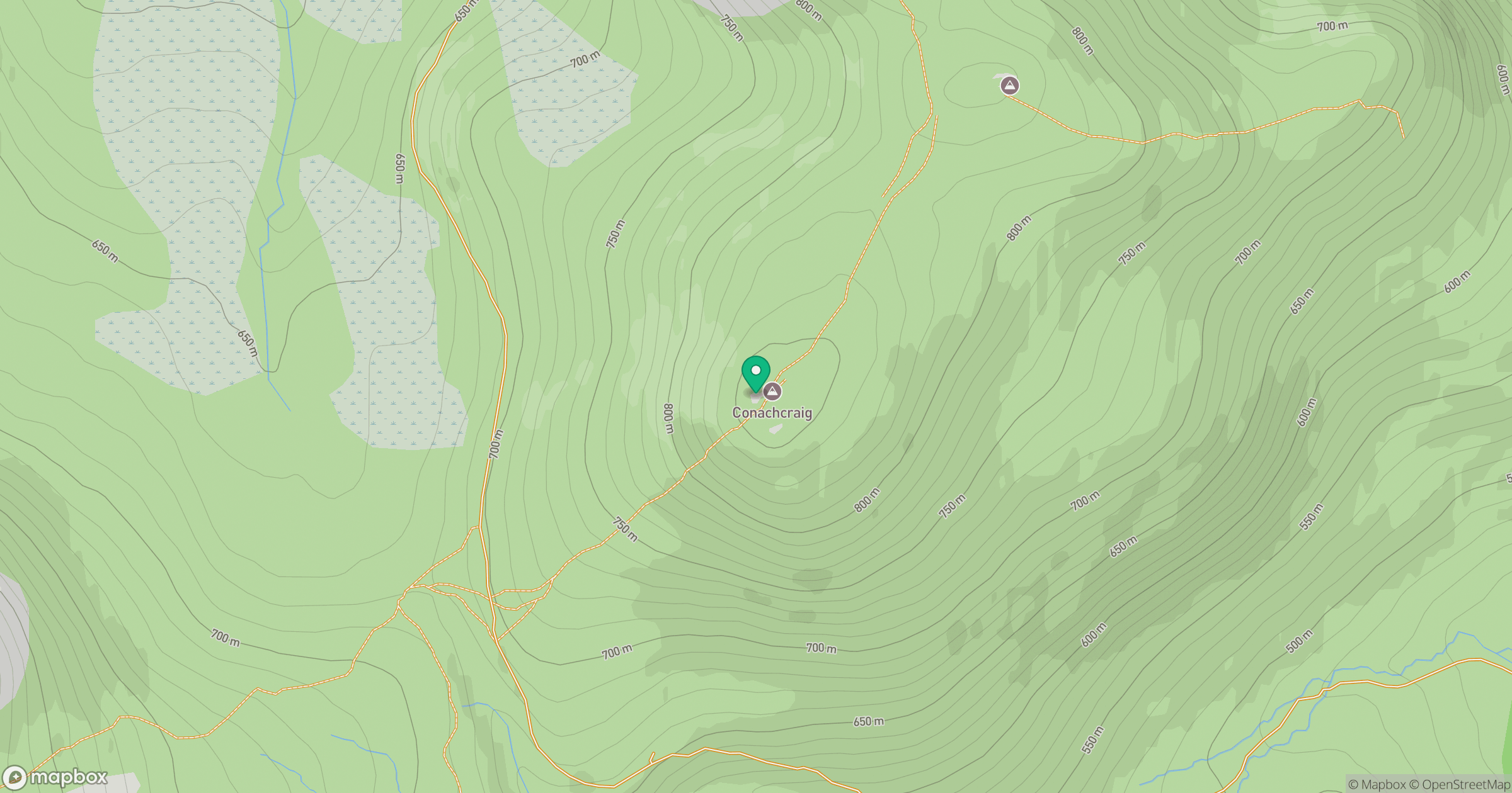
Grid reference: NO279865
View on OpenStreetMapOpens a map in a new tab, centred on the hill.
No comments yet. Be the first.