

Lochnagar - Cac Carn Beag
Good walks are even better shared.
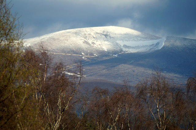
NO2486 : Cac Carn Beag and the ridge beyond
Trevor Littlewood Photo source
Overview
Lochnagar’s main summit, Cac Carn Beag, is a 1,155.7 m Munro above Royal Deeside. The mountain has a cliff-rimmed northern corrie and long approaches from Glen Muick or Crathie.
Lochnagar - Cac Carn Beag
Overview
Lochnagar’s main summit is Cac Carn Beag, a 1,155.7 m Munro above Royal Deeside. The summit is a rocky tor beside a trig point, with a broad plateau behind the steep northern corrie. Cac Carn Mor is a separate, lower top at 1,151.3 m; Meikle Pap is 978.9 m.
Walking routes
The Glen Muick circuit starts and finishes at Spittal of Glen Muick: climb by Allt-na-giubhsaich and the Ladder, visit Cac Carn Beag, then return down Glas Allt and along Loch Muick. The complete outing is 19 km and usually described as 6–7 hours in summer.
For a much longer mountain day, the White Mounth circuit links Lochnagar with four further Munros and returns from Broad Cairn to Spittal above Loch Muick. Its published figures are 29 km and 9–11 hours. The alternative northern circuit from Crathie uses Gelder Shiel and Meall Coire na Saobhaidhe, returns by the Ladder and estate tracks, and is 25.7 km with a 7–8-hour published time. See the route notes for each complete itinerary.
Ground and landscape
The usual Glen Muick route combines estate tracks, pitched mountain paths, boulders and a steep descent beside Glas Allt. The northern approach has rougher, partly pathless moorland. These are substantial mountain walks requiring fitness and navigation skills.
Lochnagar is built from intrusive granite emplaced in several phases. Glaciation excavated its corries, while frost-related processes also shaped the upper slopes. The corrie rim, the lochan beneath it, the Glas Allt falls and Loch Muick give the main circuit its changing character. Clear weather opens views across Deeside and the Cairngorms.
Access
Use the paid car park at Spittal of Glen Muick for the eastern routes. Toilets and a small visitor centre are at Spittal; bring provisions for the mountain. There is no scheduled public transport to this trailhead. Crathie is the start of the longer northern route.
Check estate notices before setting out. NatureScot’s access guidance allows the main Glen Muick and Glas Allt paths during stalking, and the five-Munro circuit provided walkers do not make an early descent across the White Mounth or into the Dubh Loch area. The pathless northern variant needs its own access check. Keep dogs close at heel or on a short lead around ground-nesting birds, especially April–July, and respect the estate’s request to avoid camping around Spittal and Loch Muick.
Safety and seasons
The corrie cliffs are serious fall hazards. Keep well back from their edges, especially in mist, strong wind or snow. The Ladder can hold unstable snow, and cornices can conceal the true rim. Heavy rain can make the burn crossing and the steep Glas Allt descent more difficult.
Carry a map and compass, waterproofs, warm layers, food and a headtorch. Snow and ice require winter navigation and avalanche-awareness skills, appropriate boots, crampons and an ice axe, with the ability to use them. Check a mountain forecast and the Southern Cairngorms avalanche information when issued; read its validity date. A summer itinerary or timing is not a winter safety assessment.
Names and history
Lochnagar takes its name from Loch na Gàire, the small corrie loch; Ainmean-Àite na h-Alba interprets this as “the loch of the outcry”. The mountain is associated with Lord Byron’s poem about dark Lochnagar and with Queen Victoria’s visits.
Explore routes near Lochnagar - Cac Carn Beag
Walks starting near this hill. Open a route to check its map, distance and full itinerary.
Loch Muick full circuit from Spittal of Glen Muick
View route
Cairngorms night walk and stargazing (event meeting)
View route
Cairngorms night walk and stargazing (event meeting)
View route
Cairngorms night walk and stargazing (event meeting)
View route
Route planning notes
These notes describe possible approaches. Check a route's map and access information when planning your walk.
Lochnagar circuit from Glen Muick
From Spittal of Glen Muick car park (NO309851), cross the glen to Allt-na-giubhsaich and climb towards the Meikle Pap bealach. Ascend the Ladder path, then continue across the plateau past Cac Carn Mor to Cac Carn Beag, Lochnagar’s main summit. Return past Cac Carn Mor and descend the Glas Allt path to Glas-allt-Shiel. Follow Loch Muick’s northwest shore, cross the outflow footbridge near the boathouse, and return to Spittal. This complete circular walk is 19 km, with 930 m ascent in Walkhighlands and a published summer time of 6–7 hours. Stay back from the corrie cliffs; the Ladder is avalanche-prone under snow.
White Mounth five-Munro circuit
Start and finish at Spittal of Glen Muick (NO309851). Reach Lochnagar via Allt-na-giubhsaich and the Ladder, then continue over Carn a’ Choire Bhoidheach, Carn an t-Sagairt Mor, Cairn Bannoch and Broad Cairn. Descend east over Broad Cairn’s boulders to the track, follow its plateau traverse and zigzags, cross the Black Burn bridge and follow the Loch Muick-side track back to Spittal. The full five-Munro circuit is 29 km with 1,228 m ascent; allow the published 9–11 hours in summer. The broad plateau needs confident navigation in cloud. During stalking, avoid unplanned early descents across the White Mounth or into the Dubh Loch area.
Lochnagar circuit from Crathie via Gelder Shiel
Start and finish at Crathie car park (NO262950). Cross the Dee and follow the route through Easter Balmoral and the woods to Gelder Shiel. Cross the Gelder Burn, continue to the track end, then use faint paths and rough ground east of Creag Liath to Meall Coire na Saobhaidhe. Continue south to Cac Carn Beag. Return via Cac Carn Mor, the eastern plateau and the Ladder to the Meikle Pap bealach, then descend east to the estate track and follow it back to Balmoral and Crathie. UKHillwalking gives 25.7 km, 1,032 m ascent and 7–8 hours. Some northern ground is boggy and almost pathless; check current estate stalking advice before using that section.
Make a day of it, together
Find someone to share the walk with, or organise a day out along a route you like.
Photo Gallery
View all Photo could not load
NO2486 : Cac Carn Beag and the ridge beyond
Trevor Littlewood
 Photo could not load
NO2486 : Descending from the summit of Lochnagar
Gwen and James Anderson
 Photo could not load
NO2486 : Cac Carn Beag viewpoint indicator
Alan Reid
 Photo could not load
NO2486 : Deer at the summit of Cac Carn Beag
Ralph Greig
 Photo could not load
NO2486 : Summit tor of Cac Carn Beag in February snow
Keith Burns
 Photo could not load
NO2486 : Approaching Cac Carn Beag from the Stuic
Keith Burns
 Photo could not load
NO2486 : Cac Carn Beag of Lochnagar from Cnapan Nathraichean spur
Keith Burns
 Photo could not load
NO2486 : Summit of Cac Carn Beag (Lochnagar)
Alan O'Dowd
 Photo could not load
NO2486 : View north from Carn Cac Beag
Nigel Brown

NO2486 : Carn Cac Beag
Nigel Brown
Hill facts and local notes
Classifications
Elevation
1,156m
3,792 ft
Prominence
671m
Coordinates
56.9603, -3.2453
NO243861
OS Map
44
Explorer: OL53N 388N
At the Summit
The high point is the rock tor 2 m northeast of the trig point at Cac Carn Beag. A viewpoint indicator is nearby. Cac Carn Mor is a separate, lower top.
Terrain & Geology
Lochnagar is a granite massif formed from several intrusive phases. Its steep northern corrie and moraines record glaciation; boulder lobes and terraces on the upper slopes also record cold-climate, frost-related processes.
Views & Scenery
The northern corrie and its lochan are prominent from the Meikle Pap bealach and corrie rim. In clear weather the summit looks across Deeside and the Cairngorms; the Glas Allt descent opens views over Loch Muick.
History & Heritage
Name Origin
Lochnagar comes from Loch na Gàire, the small loch in the northern corrie, interpreted by Ainmean-Àite na h-Alba as “the loch of the outcry”. The recorded Gaelic mountain name is Beinn nan Cìochan. Cac Carn Beag names the main summit.
Historical Significance
Lochnagar inspired Lord Byron’s poem about “dark Lochnagar”. Queen Victoria also climbed the mountain; Glas-allt-Shiel by Loch Muick is associated with her retreats on the Balmoral Estate.
Getting There & Facilities
Parking
Spittal of Glen Muick pay car park, NO309851, at the end of the public road from Ballater, serves the Glen Muick and White Mounth circuits. Check the displayed charge and local access notices. The northern circuit starts at Crathie pay car park, NO262950. The Spittal access bridge closed in March 2026 was reported reopened by the estate in April 2026; check for any newer notices before travel.
Public Transport
There is no scheduled public transport to Spittal of Glen Muick. Arrange the onward journey from Ballater. The longer northern route starts at Crathie, which has bus access from Ballater; check the current timetable and last return before committing to that circuit.
Nearby Facilities
Toilets and a small visitor centre are at Spittal of Glen Muick. Bring food, water and mountain equipment; do not rely on refreshments being available at the trailhead.
Safety Information
Known Hazards
- Sheer northern corrie cliffs and gullies: keep well back, particularly in mist or strong winds.
- The Ladder is a steep boulder ascent with avalanche exposure under snow; cornices can overhang the corrie rim.
- The broad plateau and partly pathless northern approach require reliable navigation in poor visibility.
- Heavy rain can make the Allt na Guibhsaich crossing difficult; wet or icy rock adds risk on the steep Glas Allt descent.
Seasonal Hazards
Snow and ice can hide paths and create avalanche and cornice hazards. Winter travel needs appropriate boots, crampons, an ice axe and the skills to use them. Check a mountain forecast and the Southern Cairngorms avalanche information when issued, including its validity date. In stalking periods use the main Glen Muick/Glas Allt paths or the full five-Munro circuit; check estate advice for pathless northern approaches and avoid early White Mounth/Dubh Loch descents. Short daylight makes the long circuits especially committing.
General Safety Tips
- Check weather conditions before setting out
- Carry appropriate clothing and equipment
- Let someone know your planned route
- Take a map, compass, and GPS device
- Carry emergency supplies: food, water, first aid kit, torch
Hills
Some common questions about the hills answered
Are there group walks up Lochnagar - Cac Carn Beag?
Many walkers use Walkmates to join or organise walks with others. You can check for group walks around Lochnagar - Cac Carn Beag through the maps
Are there other walkers around Lochnagar - Cac Carn Beag?
Activity varies by location and time, but Walkmates lets you see whether others have shared walks or shown interest in this area. Find other people through the walking friends search walking friends for Lochnagar - Cac Carn Beag search or of course create your own walk for Lochnagar - Cac Carn Beag
Can I organise a walk to Lochnagar - Cac Carn Beag?
Yes. If there aren’t any walks listed already, you can create a walk and make it available for others to join.
If you're signed up to Walkmates, you can create a walk to Lochnagar - Cac Carn Beag.
How do I find a walk up this hill?
There are often multiple ways to walk this hill, depending on experience and route preference. Walkmates helps you explore walks and routes that others have shared.
Can I suggest a new route up Lochnagar - Cac Carn Beag?
Yes. You can suggest or create routes to share with others. Walkmates focuses on the social side of walking, so routes are used to help people organise walks and explore areas together, rather than as detailed navigation tools or route libraries.
Other uses really appreciate knowledgeable walkers sharing their routes. Share your favourite route to Lochnagar - Cac Carn Beag here
The is an error or something incorrect about this hill. How do I let you know?
We always strive to keep the information on Walkmates as accurate as possible. If you find an error, please let us know through the contact form and we'll aim to correct it as quickly as possible
Community Discussion
Comments
Location
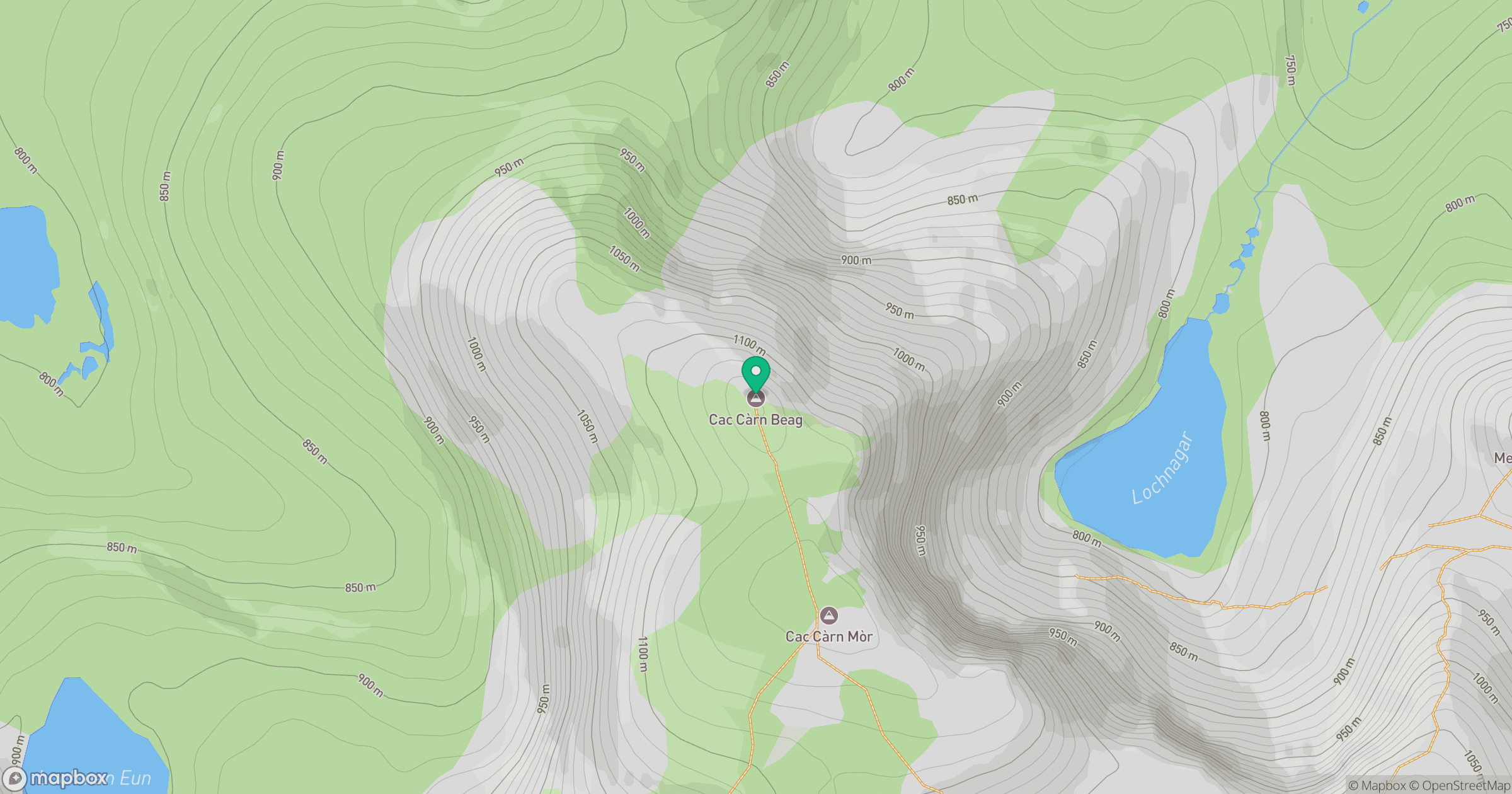
Grid reference: NO243861
View on OpenStreetMapOpens a map in a new tab, centred on the hill.
No comments yet. Be the first.