

Carn an Tionail
Good walks are even better shared.
NC3939 : Summit of Carn an Tionail
Andrew Spenceley Photo source
Overview
Carn an Tionail
Overview
Carn an Tionail rises majestically to an elevation of 644 meters, proudly classified as a Marilyn. Nestled within the rugged beauty of the Scottish Highlands, it's a summit that welcomes both novice hikers and seasoned trekkers alike.
Geology
The mountain is predominantly composed of metamorphic rocks, including schist and gneiss. These ancient stones carry stories from millions of years ago, blanketing the landscape in a prehistoric charm that often leaves visitors pondering while they take in the view.
Routes
One of the most accessible routes is the B851 Approach, offering a delightful 8-kilometre trek that usually takes around 2.5 hours to complete. The journey features a steady incline and lovely landscape views, inviting you to pause for a breather—there’s nothing wrong with enjoying the scenery, after all.
Summit Features
Upon reaching the summit, the first thing you’ll notice is the impressive stone cairn, which not only marks the top but also serves as a poignant reminder of the countless outdoor enthusiasts who have come before you. Perfect for a triumphant selfie!
Terrain Type
Expect a mix of grassy slopes interspersed with rocky outcrops. A few boggy patches could catch you off guard, so make sure your boots are up to the challenge. Nothing says 'happy hiker' like sodden socks, eh?
Views
The vistas from Carn an Tionail are nothing short of breathtaking. To the south, you'll catch a glimpse of the Monadhliath Mountains emerging dramatically from the landscape, while Loch Ness glistens invitingly off to the north-west. For the best photography opportunities, aim for spring and early autumn when the weather is usually more forgiving and the colours pop!
Hazards
Every mountain has its quirks! Be aware of the unpredictable weather conditions that can change from sunny to absolutely freezing in the blink of an eye. Also, keep an eye on your footing in the muddy areas; nobody wants an unexpected mud facial!
Access
Parking is available at a small area by the B851, but there’s only enough space for a handful of vehicles. If you're relying on public transport, regular buses to Inverness can get you started, although a taxi might be needed to get to the B851 junction. Drumnadrochit is the nearest town, providing all your pre-hike caffeine needs!
Facilities
Before you hit the trail, make sure you stop by one of the delightful cafes in Drumnadrochit. They have excellent coffee options (not that we’re making any assumptions about your caffeine habits!). Public toilets are also available to ensure you're good to go before the hike.
History
The name 'Carn an Tionail'—translating to 'hill of the cairn'—hints at the mountain’s historical importance and connection to the Gaelic clans of old, who likely gathered amongst its slopes.
There you have it! Everything you need to know about Carn an Tionail. Grab your boots, your best trekking mates, and head out for an unforgettable experience in the Scottish Highlands! Enjoy the trail!
Explore routes near Carn an Tionail
Walks starting near this hill. Open a route to check its map, distance and full itinerary.
Ben Klibreck
View route
Loch Migdale from Torroy: Spinningdale pinewood and loch shore walk
View route
Route planning notes
These notes describe possible approaches. Check a route's map and access information when planning your walk.
B851 Approach
A well-marked trail starting from the B851 road, this route offers hikers a steady ascent with occasional excuses to catch your breath and enjoy the scenery.
Make a day of it, together
Find someone to share the walk with, or organise a day out along a route you like.
Photo Gallery
View all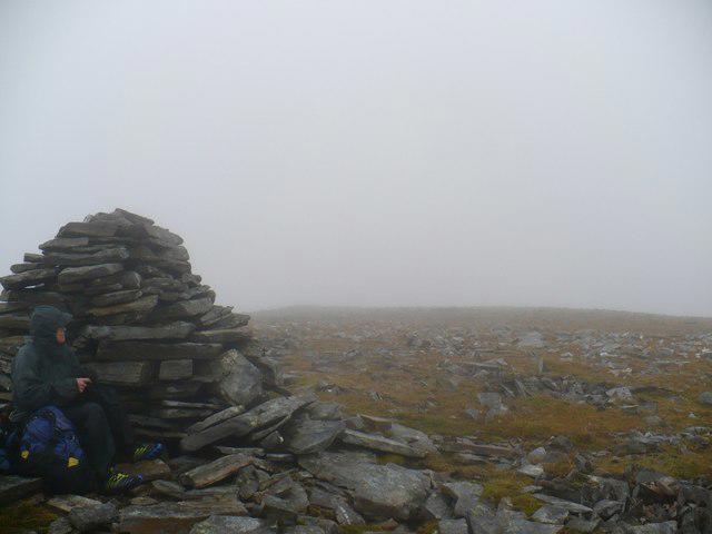 Photo could not load
NC3939 : Summit of Carn an Tionail
Andrew Spenceley
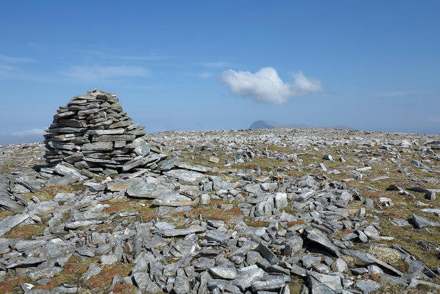 Photo could not load
NC3939 : Summit plateau of Carn an Tionail
Trevor Littlewood
Hill facts and local notes
Classifications
Elevation
758m
2,489 ft
Prominence
209m
Coordinates
58.3104, -4.7457
NC392390
OS Map
16
Explorer: 447S
At the Summit
At the summit, hikers are greeted by a substantial stone cairn, providing both a perfect Instagram backdrop and a reminder that many have ascended before them.
Terrain & Geology
Carn an Tionail is primarily composed of metamorphic rocks characteristic of the Scottish Highlands, forming part of the ancient geology that makes this region a hiker's paradise. The weathered schist and gneiss provide a fascinating geological history.
Views & Scenery
The view from the summit includes the dramatic contours of the Monadhliath Mountains to the south, and a splendid vista of Loch Ness in the north-west.
History & Heritage
Name Origin
The name 'Carn an Tionail' translates roughly to 'hill of the cairn', indicative of its highland heritage and significance to early settlers.
Historical Significance
This mountain has been a site of local lore, believed to be a gathering point for the Gaelic clans in centuries past.
Getting There & Facilities
Parking
There is a small parking area at the B851 junction near NC392390, accommodating a few vehicles.
Public Transport
Regular bus services to Inverness provide a good starting point, though a taxi may be necessary to reach the B851 junction.
Nearby Facilities
Drumnadrochit offers a handful of cafes and shops, as well as public toilets to refresh before you hit the trail.
Safety Information
Known Hazards
- Watch out for unpredictable weather and muddy conditions. Strong winds at the summit may require a steady hand and a firm grip on your hat!
General Safety Tips
- Check weather conditions before setting out
- Carry appropriate clothing and equipment
- Let someone know your planned route
- Take a map, compass, and GPS device
- Carry emergency supplies: food, water, first aid kit, torch
Hills
Some common questions about the hills answered
Are there group walks up Carn an Tionail?
Many walkers use Walkmates to join or organise walks with others. You can check for group walks around Carn an Tionail through the maps
Are there other walkers around Carn an Tionail?
Activity varies by location and time, but Walkmates lets you see whether others have shared walks or shown interest in this area. Find other people through the walking friends search walking friends for Carn an Tionail search or of course create your own walk for Carn an Tionail
Can I organise a walk to Carn an Tionail?
Yes. If there aren’t any walks listed already, you can create a walk and make it available for others to join.
If you're signed up to Walkmates, you can create a walk to Carn an Tionail.
How do I find a walk up this hill?
There are often multiple ways to walk this hill, depending on experience and route preference. Walkmates helps you explore walks and routes that others have shared.
Can I suggest a new route up Carn an Tionail?
Yes. You can suggest or create routes to share with others. Walkmates focuses on the social side of walking, so routes are used to help people organise walks and explore areas together, rather than as detailed navigation tools or route libraries.
Other uses really appreciate knowledgeable walkers sharing their routes. Share your favourite route to Carn an Tionail here
The is an error or something incorrect about this hill. How do I let you know?
We always strive to keep the information on Walkmates as accurate as possible. If you find an error, please let us know through the contact form and we'll aim to correct it as quickly as possible
Community Discussion
Comments
Location
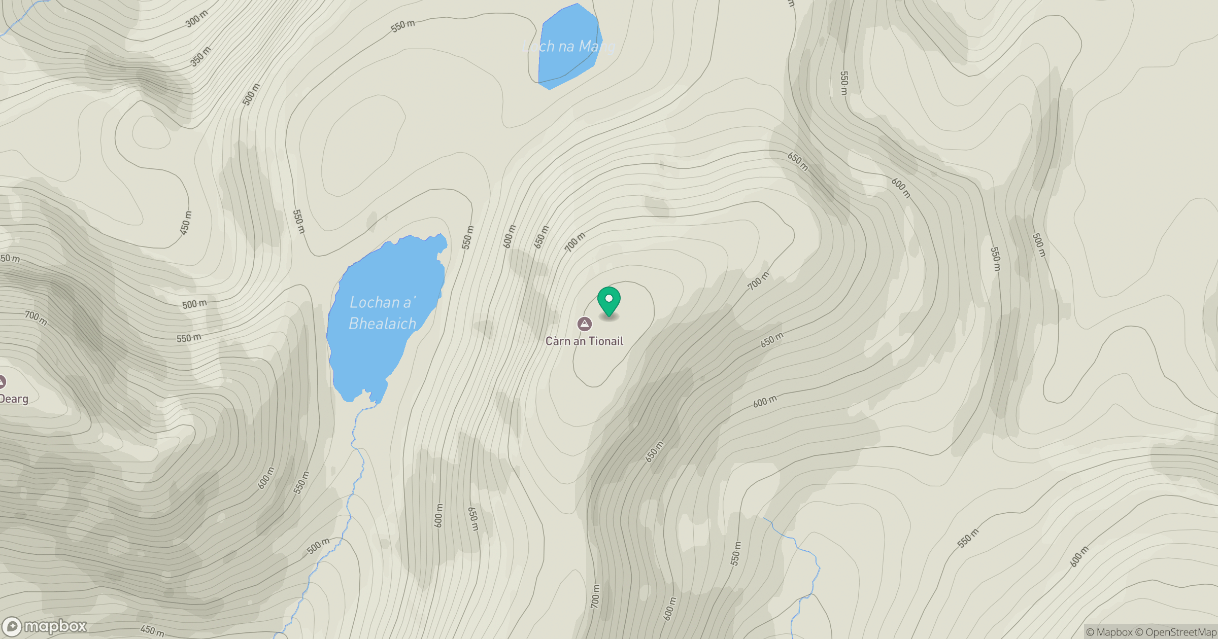
Grid reference: NC392390
View on OpenStreetMapOpens a map in a new tab, centred on the hill.
Nearby Hills
Ben Hope
927m
Ben More Assynt
999m
Ben Stack
721m
Quinag - Sail Gharbh
809m
Ben Loyal - An Caisteal
764m
No comments yet. Be the first.