

Bowness Knott
Good walks are even better shared.
NY1115 : Bowness Knott
Michael Graham Photo source
Overview
Bowness Knott: A Hidden Gem in the Lake District
Nestled in the heart of the Lake District, Bowness Knott stands proudly at 265 meters, offering stunning views and a rewarding hike for those willing to lace up their boots. Famously dubbed a 'Marilyn', it may not be the highest peak, but it serves up charm and accessibility in spades.
Geology
The rock formations found around Bowness Knott belong to the Borrowdale Volcanic Group, showcasing ancient volcanic activity. If you're a rock nerd, this area is a treat, providing insights into the fascinating geological history of the region.
Routes
The Bowness Knott Loop is a popular starting point that winds its way through the lush greenery surrounding Bowness-on-Windermere. This moderate trail stretches approximately 8 km and typically takes about 2.5 hours to complete, depending on how many times you stop to take photos or shout, "Look at that view!"
Summit Features
At the summit, you'll find a quaint cairn which not only denotes the peak but also serves as the ideal spot for those all-important summit selfies. Just remember to smile and look like you’ve just solved the mysteries of the universe!
Terrain
Bowness Knott presents a mix of grassy expanses, rocky outcrops, and an occasional bog—don’t let your new boots get too muddy!
Views
From the summit, the sight of Windermere Lake sparkling below is simply awe-inspiring, especially during late spring and early autumn when the colours are at their most vivid. A perfect spot for a picnic... if the seagulls are kept at bay!
Hazards
As with any hike, there are a few hazards—mainly uneven terrain and some slippery patches after rain. It’s recommended to wear sturdy footwear to keep those ankles sprightly!
Access
Easily accessible from Bowness-on-Windermere, the nearest parking facilities are at the Bowness Pier, and there are public transport options aplenty, including regular bus services from Windermere railway station.
Facilities
Once you've conquered the Knott, reward yourself with a lovely slice of cake at one of the many cafés in Bowness, or grab a pint at a local pub—both highly encouraged!
History
The name 'Bowness' translates to 'headland' in Old Norse, perfectly describing its scenic elevation. Its historical significance as a centre for trade makes it a point of interest for history buffs!
Conclusion
Bowness Knott isn’t just a hill; it's a delightful day out filled with scenic views, geological wonders, and a hearty slice of history. So dust off those walking boots and get out there!
Happy Hiking!
Explore routes near Bowness Knott
Walks starting near this hill. Open a route to check its map, distance and full itinerary.
Steeple, Scoat Fell and Haycock from Ennerdale
View route
Scafell Pike via Brown Tongue and Hollow Stones
View route
Scafell Pike from Seathwaite via the Corridor Route
View route
Whinlatter dark skies walk
View route
Route planning notes
These notes describe possible approaches. Check a route's map and access information when planning your walk.
Bowness Knott Loop
A scenic loop starting from the village of Bowness-on-Windermere, featuring gentle slopes and stunning views.
Make a day of it, together
Find someone to share the walk with, or organise a day out along a route you like.
Photo Gallery
View all Photo could not load
NY1115 : Bowness Knott
Michael Graham
 Photo could not load
NY1115 : Ennerdale Water, viewed from the approach road from Croasdale
Derek Voller
 Photo could not load
NY1115 : Bowness Knott From Cauda Brow
DANNY SEWARD
 Photo could not load
NY1115 : Forest clearance on Bowness Knott
David Brown
 Photo could not load
NY1115 : Bowness Knott
Michael Graham
 Photo could not load
NY1115 : Designer Chair, Bowness Knott
Michael Graham
 Photo could not load
NY1115 : On Bowness Knott
Michael Graham
 Photo could not load
NY1115 : Pile of stones on Bowness Knott
David Brown
 Photo could not load
NY1115 : Ennerdale Water and fells
Richard Thomas
 Photo could not load
NY1115 : Bowness Knott and Ennerdale Water
Ibn Musa
Hill facts and local notes
Classifications
Elevation
333m
1,093 ft
Prominence
41m
Coordinates
54.5275, -3.3733
NY112155
OS Map
89
Explorer: OL4S 303
At the Summit
The summit features a modest cairn, providing a perfect backdrop for your summit selfies (don't forget to put your best foot forward!).
Terrain & Geology
The area primarily consists of volcanic rocks from the Borrowdale Volcanic Group, making it a fascinating study for geology enthusiasts and an excellent canvas for those who appreciate a bit of rugged scenery.
Views & Scenery
From the summit, you can gaze upon the rolling hills of the Lake District and catch glimpses of Windermere Lake shimmering in the sunlight.
History & Heritage
Name Origin
The name 'Bowness' is derived from the Old Norse term meaning 'headland', while 'Knott' refers to a hill, apt for the topography here.
Historical Significance
Historically, Bowness was an important centre for trade and tourism, with roots going back to medieval times.
Getting There & Facilities
Parking
Bowness-on-Windermere offers several public car parks; the main one is at the Bowness Pier with facilities available.
Public Transport
Regular bus services run from Windermere railway station to Bowness-on-Windermere.
Nearby Facilities
Bowness-on-Windermere has numerous cafés, pubs, and public toilets—perfect for a pre-hike coffee or post-climb refreshment!
Safety Information
Known Hazards
- Uneven ground and occasional slippery patches, especially after rain—be sure to wear appropriate footwear!
General Safety Tips
- Check weather conditions before setting out
- Carry appropriate clothing and equipment
- Let someone know your planned route
- Take a map, compass, and GPS device
- Carry emergency supplies: food, water, first aid kit, torch
Hills
Some common questions about the hills answered
Are there group walks up Bowness Knott?
Many walkers use Walkmates to join or organise walks with others. You can check for group walks around Bowness Knott through the maps
Are there other walkers around Bowness Knott?
Activity varies by location and time, but Walkmates lets you see whether others have shared walks or shown interest in this area. Find other people through the walking friends search walking friends for Bowness Knott search or of course create your own walk for Bowness Knott
Can I organise a walk to Bowness Knott?
Yes. If there aren’t any walks listed already, you can create a walk and make it available for others to join.
If you're signed up to Walkmates, you can create a walk to Bowness Knott.
How do I find a walk up this hill?
There are often multiple ways to walk this hill, depending on experience and route preference. Walkmates helps you explore walks and routes that others have shared.
Can I suggest a new route up Bowness Knott?
Yes. You can suggest or create routes to share with others. Walkmates focuses on the social side of walking, so routes are used to help people organise walks and explore areas together, rather than as detailed navigation tools or route libraries.
Other uses really appreciate knowledgeable walkers sharing their routes. Share your favourite route to Bowness Knott here
The is an error or something incorrect about this hill. How do I let you know?
We always strive to keep the information on Walkmates as accurate as possible. If you find an error, please let us know through the contact form and we'll aim to correct it as quickly as possible
Community Discussion
Comments
Location
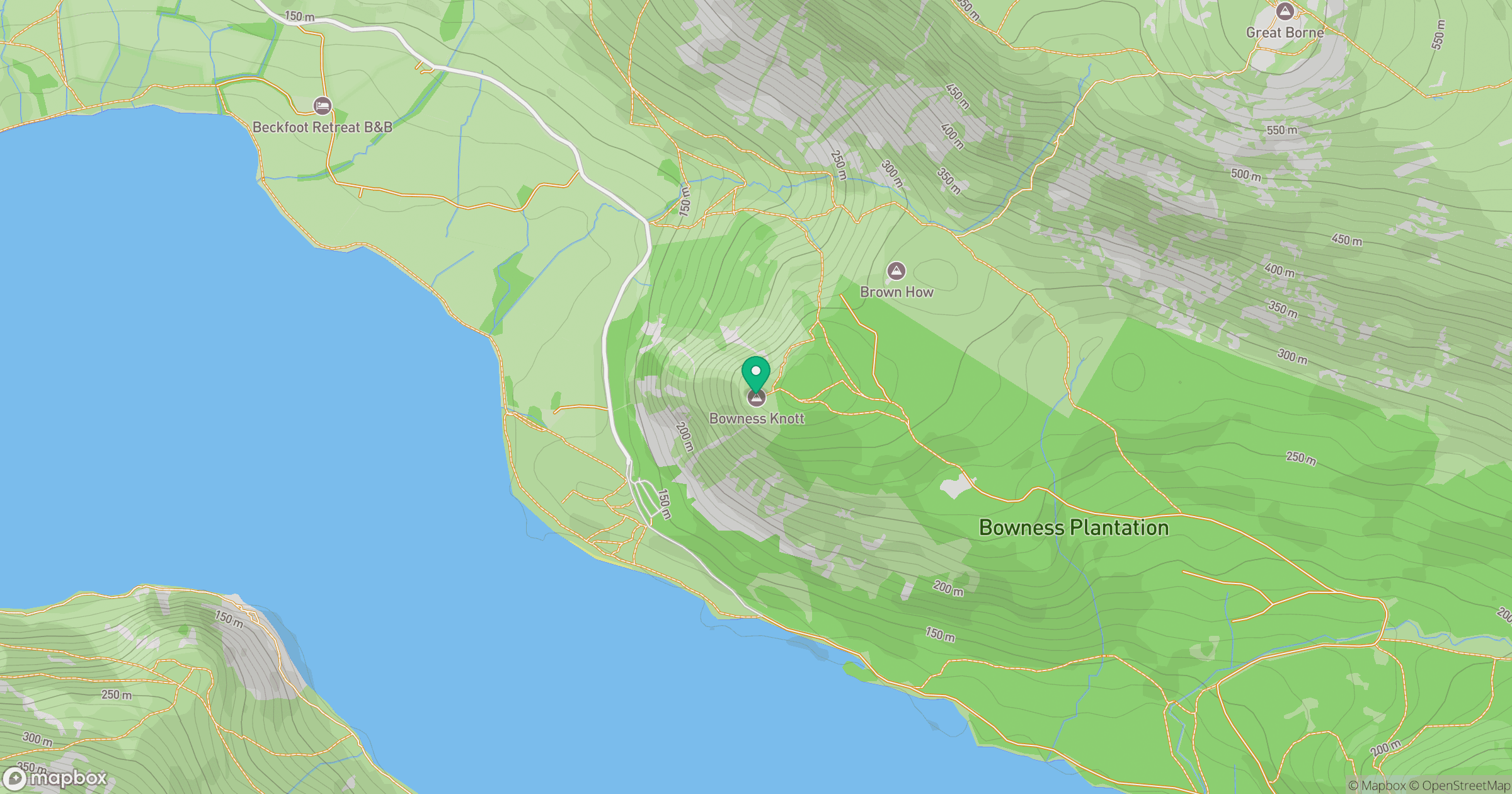
Grid reference: NY112155
View on OpenStreetMapOpens a map in a new tab, centred on the hill.
Nearby Hills
High Stile [Grey Crag - High Stile]
806m
Pillar
892m
Grasmoor
852m
Crag Hill [Eel Crag]
839m
Fleetwith Pike
649m
No comments yet. Be the first.