

Bersham Bank
Good walks are even better shared.
SJ3148 : Filling station at Wrexham Services
John Lucas Photo source
Overview
Overview
Bersham Bank is a modest hill situated near Wrexham, North Wales, reaching an elevation of 232 meters. Though not towering by any means, it offers delightful hikes with rewarding views, perfect for both novice and experienced walkers alike.
Geology
The hill is primarily made up of sedimentary rocks, including sandstone and shale. These formations provide an insight into the area’s geological history, revealing the story of erosion and sediment deposition over time. Remember, these rocks may not be great for selfies, but they certainly tell a tale worth hearing!
Routes
- Bersham Bank Circular Route: This route spans approximately 4.5 km and takes around 1.5 hours to complete. This easy-to-follow path begins in the village of Bersham and wraps around the hill, providing variety in scenery and terrain.
- Bersham to Brymbo Trail: For the more adventurous, this challenging 5 km trail connects Bersham Bank to Brymbo, featuring steeper sections that are sure to get your heart racing.
Summit Features
The summit is adorned with a well-placed cairn, marking the peak with modest charm. Don’t forget to snap a picture here – after all, it's not every day you can claim you’ve conquered a hill!
Terrain Type
The terrain is mostly grassy with charming rocky outcrops thrown in for good measure, along with sneaky patches of gorse that may just take a swipe at your trousers! Keep an eye out for mud – it likes to surprise hikers after a rain shower.
Views
Once you reach the summit, you’ll be treated to sweeping vistas of the surrounding countryside, including the Vale of Llangollen and the presiding peaks of Snowdonia if you’re lucky. Spring and early autumn are best for hiking, when the weather is agreeable and the landscape bursts with colour.
Hazards
As always, hikers should take caution: watch for uneven ground and loose rocks, especially on steeper trails. Muddy sections can also pose a challenge, so sturdy footwear is recommended.
Access
The nearest parking is available near the circular route in Bersham, providing space for about a dozen vehicles. Public transport options are available, with buses running from Wrexham, making access easy for day trippers. After your hike, don't miss the chance to explore Wrexham, which has a variety of cafes to help replenish those energy levels!
Facilities
While there are no facilities directly on the hill, you can find several in Wrexham, where cafes, pubs, and stores await to welcome hikers back to civilisation!
History
The name 'Bersham' translates to 'the home of the bees', and the hill has historical significance tied to the industrial roots of the region’s ironworks and coal mining past.
Conclusion
Bersham Bank may lack the height of giants, but its charm and accessibility make it a wonderful spot for a day’s adventure. Whether you’re after scenic views, a leisurely walk, or a little piece of Welsh history, this bank has it all, minus the hefty fees!
Explore routes near Bersham Bank
Walks starting near this hill. Open a route to check its map, distance and full itinerary.
World’s End and back
View route
Llangollen to Horseshoe Falls: Canal Towpath from Market Street
View route
Ellesmere Walk with Men Walking & Talking
View route
Oswestry Walk with Men Walking & Talking
View route
Route planning notes
These notes describe possible approaches. Check a route's map and access information when planning your walk.
Bersham Bank Circular Route
A delightful circular route starting from the village of Bersham, offering various terrains and splendid views along the way.
Bersham to Brymbo Trail
A more challenging trail connecting Bersham Bank to nearby Brymbo, with steep sections to keep the heart pumping and the views unmatched.
Make a day of it, together
Find someone to share the walk with, or organise a day out along a route you like.
Photo Gallery
View all Photo could not load
SJ3148 : Filling station at Wrexham Services
John Lucas
 Photo could not load
SJ3148 : Little Chef near Rhostyllen
Bill Boaden
 Photo could not load
SJ3148 : Road into Wrexham at Rhostyllen
John Firth
 Photo could not load
SJ3148 : Filling station by the Travelodge at Rhostyllen
Steve Daniels
 Photo could not load
SJ3148 : Rain tracks on the spoil heap
Ian Paterson
 Photo could not load
SJ3148 : Evans Halshaw
John H Darch
 Photo could not load
SJ3147 : A483 at junction 3 (A5152)
Peter Whatley
 Photo could not load
SJ3148 : Evans Halshaw, Rhostyllen
Eirian Evans
 Photo could not load
SJ3148 : A5152 nearing A483 interchange
John Firth

SJ3148 : A483 roundabout at Rhostyllen
Eirian Evans
Hill facts and local notes
Classifications
Elevation
154m
504 ft
Prominence
47m
Coordinates
53.0259, -3.0278
SJ311481
OS Map
117
Explorer: 256
At the Summit
The summit boasts a modest cairn, which may not win any beauty contests but certainly serves its purpose as a marker for weary travelers. Don’t forget to take a picture – it’s the perfect backdrop for your climbing achievements!
Terrain & Geology
Primarily composed of sedimentary rocks, including sandstone and shale, which give the hill its characteristic earthy hues. The erosion patterns reveal a fascinating geological history over millennia.
Views & Scenery
On a clear day, stunning views of the surrounding countryside, including the picturesque Vale of Llangollen and even the distant peaks of Snowdonia can be admired from the summit.
History & Heritage
Name Origin
The name ‘Bersham’ derives from the Welsh meaning 'the home of the bees', indicating its historical association with apiculture.
Historical Significance
Historically, the area has roots in the industrial revolution, with ironworks and coal mines playing a significant role in local development.
Getting There & Facilities
Parking
There is a small car park at the start of the circular route in Bersham, capable of accommodating a dozen or so vehicles.
Public Transport
Easily accessible by local bus services from Wrexham, with a short walk to the starting point.
Nearby Facilities
While there are no facilities directly on Bersham Bank, nearby Wrexham offers a range of cafes, pubs, and grocery stores to refuel after your adventures. Public toilets can also be found in Wrexham.
Safety Information
Known Hazards
- Uneven terrain and occasional loose rocks. Muddy conditions after heavy rainfall may increase the risk of slipping.
General Safety Tips
- Check weather conditions before setting out
- Carry appropriate clothing and equipment
- Let someone know your planned route
- Take a map, compass, and GPS device
- Carry emergency supplies: food, water, first aid kit, torch
Hills
Some common questions about the hills answered
Are there group walks up Bersham Bank?
Many walkers use Walkmates to join or organise walks with others. You can check for group walks around Bersham Bank through the maps
Are there other walkers around Bersham Bank?
Activity varies by location and time, but Walkmates lets you see whether others have shared walks or shown interest in this area. Find other people through the walking friends search walking friends for Bersham Bank search or of course create your own walk for Bersham Bank
Can I organise a walk to Bersham Bank?
Yes. If there aren’t any walks listed already, you can create a walk and make it available for others to join.
If you're signed up to Walkmates, you can create a walk to Bersham Bank.
How do I find a walk up this hill?
There are often multiple ways to walk this hill, depending on experience and route preference. Walkmates helps you explore walks and routes that others have shared.
Can I suggest a new route up Bersham Bank?
Yes. You can suggest or create routes to share with others. Walkmates focuses on the social side of walking, so routes are used to help people organise walks and explore areas together, rather than as detailed navigation tools or route libraries.
Other uses really appreciate knowledgeable walkers sharing their routes. Share your favourite route to Bersham Bank here
The is an error or something incorrect about this hill. How do I let you know?
We always strive to keep the information on Walkmates as accurate as possible. If you find an error, please let us know through the contact form and we'll aim to correct it as quickly as possible
Community Discussion
Comments
Location
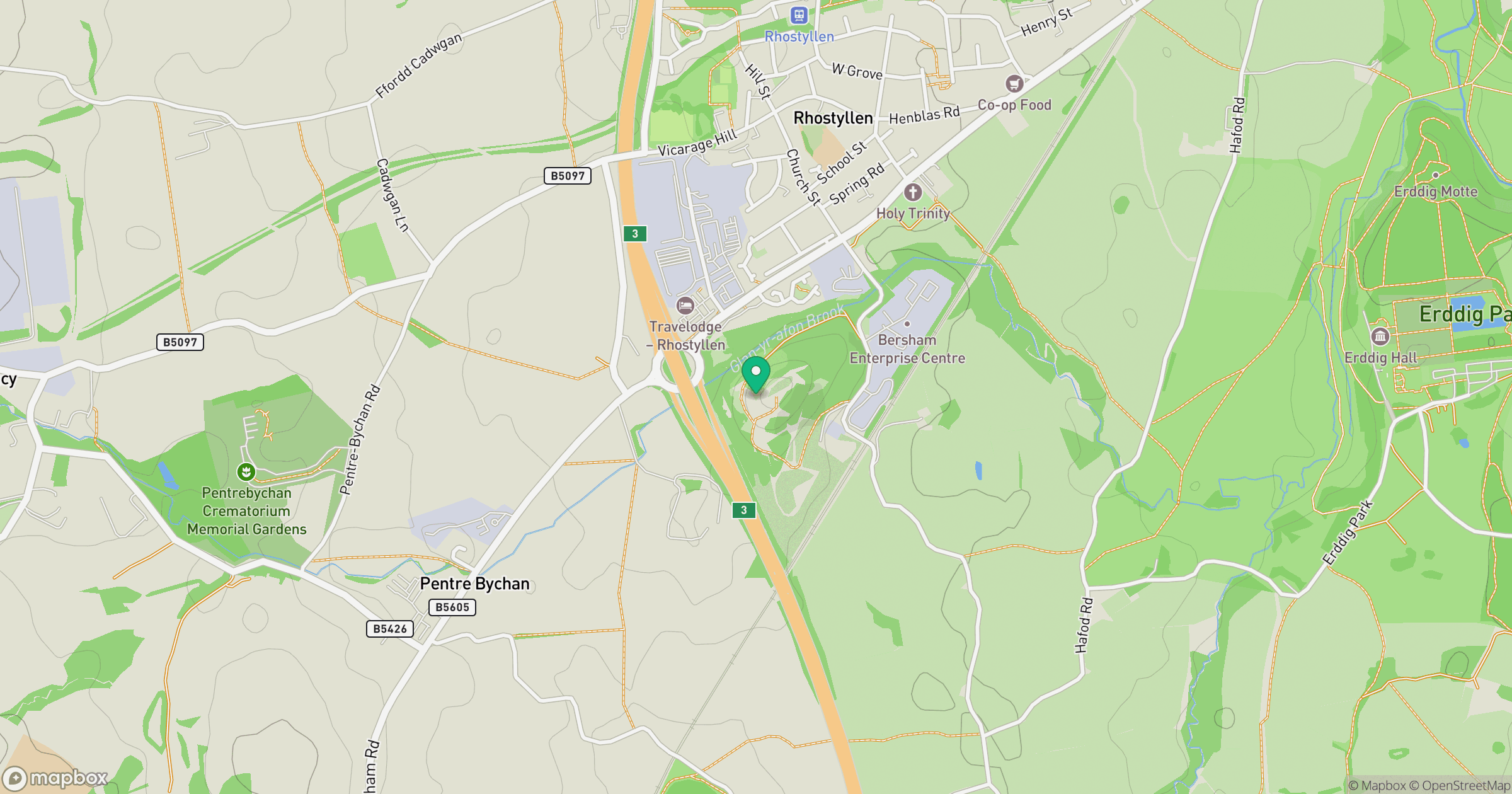
Grid reference: SJ311481
View on OpenStreetMapOpens a map in a new tab, centred on the hill.
No comments yet. Be the first.