
Beinn a' Chaorainn
Good walks are even better shared.
Overview
Beinn a' Chaorainn
Introduction
Beinn a' Chaorainn stands proudly at 1001 meters in the heart of the Scottish Highlands. This Munro, with its striking views and diverse terrain, is a must-visit for hikers and nature lovers alike.
Geology
Composed predominantly of granite and schist, Beinn a' Chaorainn provides a unique insight into the geological processes that have shaped the Highlands. Glacial features abound, giving the landscape a rugged charm that can leave you breathless – both from the view and the uphill slog!
Routes
The Monadhliath Circuit is the most popular route, beginning at Garva Bridge. Clocking in at about 14km, this moderate trail offers a mixed bag of terrains. Be prepared for rocky paths and the odd bog that tests your footwear's waterproofing!
Summit Features
The summit greets you with a substantial cairn and the iconic trig point. It's the perfect spot to catch your breath and snap a few pics for the 'gram – just beware of the wind that seems to have a personal vendetta against summit-goers.
Terrain Type
Expect rocky paths, interspersed with grassy patches and the occasional bog – so tread carefully!
Views
From the summit, panoramic views sweep over Loch Ness and the mighty Grampian Mountains. It's a sight that'll make you swear you're looking at a postcard. Late spring and early autumn are the prime seasons for these views, as the weather is kinder and the landscape more vibrant.
Hazards
Weather in the Highlands is as variable as a cat in a room full of rocking chairs. Be mindful of sudden changes. The terrain can also be unpredictable; stick to the paths, or you might find yourself knee-deep in some rather chocolaty muck!
Nearby Summits
- Carn a' Mhaim – 818 meters
- Sgor Gaibhre – 1004 meters
Access
Parking is available at Garva Bridge; just don't try to squeeze in after 9 AM on a weekend! The nearest bus service runs from Inverness to Dalwhinnie, but be prepared for a hike to get to the trailhead. Laggan is your best bet for facilities, offering a shop and café for a post-hike reward.
Conclusion
Whether you’re an experienced hillwalker or a novice looking to test your mettle, Beinn a' Chaorainn serves up a delightful combination of challenge and beauty. Don't forget your camera and a sense of adventure, as they're both essential for this splendid journey!
Happy Hiking!
Explore routes near Beinn a' Chaorainn
Walks starting near this hill. Open a route to check its map, distance and full itinerary.
Rothiemurchus: Beaver Trail and Lochan Mor
View route
Aviemore: Loch an Eilein and the Croft Track from Rothiemurchus
View route
Cairngorms night walk and stargazing (event meeting)
View route
Cairngorms night walk and stargazing (event meeting)
View route
Route planning notes
These notes describe possible approaches. Check a route's map and access information when planning your walk.
Monadhliath Circuit
A popular circuit starting at Garva Bridge, offering stunning views and varied terrain as you ascend towards the summit.
Make a day of it, together
Find someone to share the walk with, or organise a day out along a route you like.
Hill facts and local notes
Classifications
Elevation
1,083m
3,554 ft
Prominence
246m
Coordinates
57.0933, -3.5774
NJ045013
OS Map
36
Explorer: OL57S OL58S 403S 404S
At the Summit
At the summit, you'll find a substantial cairn and a trig point, perfect for a group photo or to blame for the sudden gust of wind that nearly topples you.
Terrain & Geology
Primarily composed of granite and schist, with fascinating glacial features, this mountain is a true testament to the geological forces that shaped the Highlands.
Views & Scenery
From the summit, enjoy breathtaking views of Loch Ness, the Grampian Mountains, and on a clear day, the distant views of Ben Nevis.
History & Heritage
Name Origin
The name 'Beinn a' Chaorainn' translates to 'Mountain of the Rowan Tree', reflecting the flora historically found here.
Historical Significance
This Munro is a favourite among avid hillwalkers, contributing to the culture of outdoor adventure in the Scottish Highlands.
Getting There & Facilities
Parking
Parking is available at Garva Bridge (NJ015014), with enough space for several cars. Arrive early to avoid disappointment.
Public Transport
The nearest bus service operates from Inverness to Dalwhinnie, but be prepared for a good walk to the trailhead.
Nearby Facilities
In Laggan, you can find a small shop and a café, perfect for grabbing supplies or a well-deserved slice of cake after your hike.
Safety Information
Known Hazards
- Variable weather can create difficult conditions, and the terrain, especially when wet, can be slippery. Keep an eye out for the odd bog!
- Avoid wandering off the paths as the bogs can be deceptive and nature's way of giving your boots an unexpected bath.
General Safety Tips
- Check weather conditions before setting out
- Carry appropriate clothing and equipment
- Let someone know your planned route
- Take a map, compass, and GPS device
- Carry emergency supplies: food, water, first aid kit, torch
Hills
Some common questions about the hills answered
Are there group walks up Beinn a' Chaorainn?
Many walkers use Walkmates to join or organise walks with others. You can check for group walks around Beinn a' Chaorainn through the maps
Are there other walkers around Beinn a' Chaorainn?
Activity varies by location and time, but Walkmates lets you see whether others have shared walks or shown interest in this area. Find other people through the walking friends search walking friends for Beinn a' Chaorainn search or of course create your own walk for Beinn a' Chaorainn
Can I organise a walk to Beinn a' Chaorainn?
Yes. If there aren’t any walks listed already, you can create a walk and make it available for others to join.
If you're signed up to Walkmates, you can create a walk to Beinn a' Chaorainn.
How do I find a walk up this hill?
There are often multiple ways to walk this hill, depending on experience and route preference. Walkmates helps you explore walks and routes that others have shared.
Can I suggest a new route up Beinn a' Chaorainn?
Yes. You can suggest or create routes to share with others. Walkmates focuses on the social side of walking, so routes are used to help people organise walks and explore areas together, rather than as detailed navigation tools or route libraries.
Other uses really appreciate knowledgeable walkers sharing their routes. Share your favourite route to Beinn a' Chaorainn here
The is an error or something incorrect about this hill. How do I let you know?
We always strive to keep the information on Walkmates as accurate as possible. If you find an error, please let us know through the contact form and we'll aim to correct it as quickly as possible
Community Discussion
Comments
Location
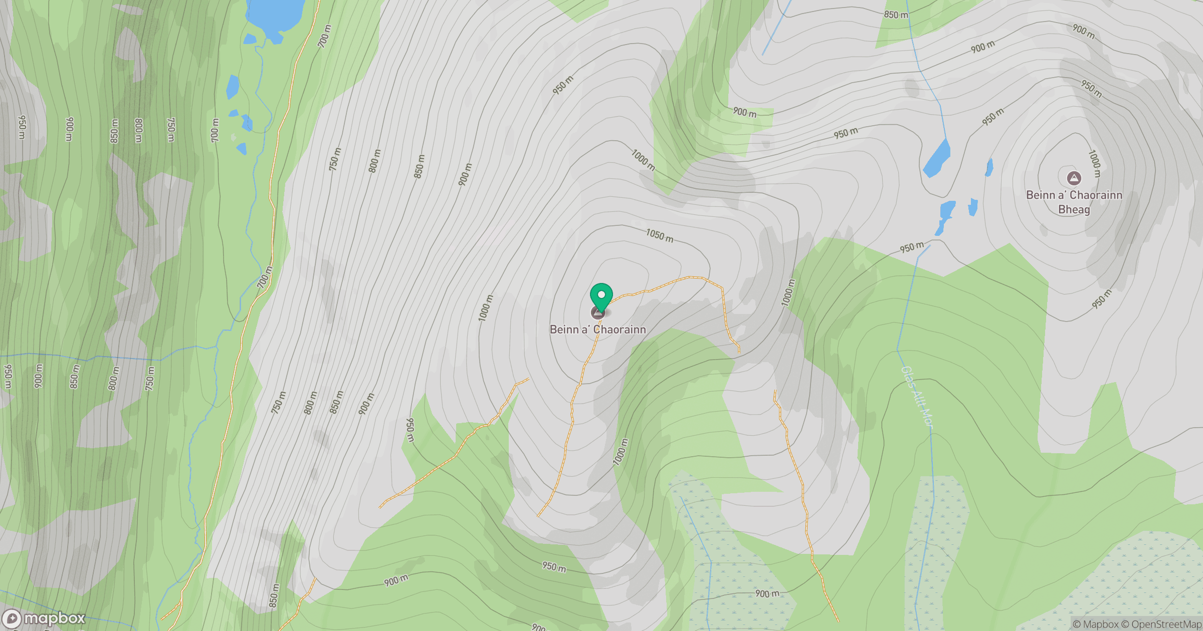
Grid reference: NJ045013
View on OpenStreetMapOpens a map in a new tab, centred on the hill.
No comments yet. Be the first.