

Sgor Fhionnaich
Good walks are even better shared.
Overview
Sgor Fhionnaich
Nestled in the heart of the Scottish Highlands, Sgor Fhionnaich stands proudly at an elevation of 723 meters, presenting a delightful challenge for adventurers looking to conquer one of Scotland’s famed Munros. Its picturesque peaks and panoramic vistas make it a bucket-list destination for any outdoor enthusiast.
Geology
The mountain showcases an intricate tapestry of schist and granite composition. The resultant geological formations tell a tale of intense glacial activity, observable through the varied terrain and sculpted ridges of the surrounding area. This geological heritage enriches the landscape and the hiking experience.
Routes
Two primary routes lead to the summit:
- Bealach a' Ghaill Route: A well-trodden path suitable for those looking for a moderate challenge. Starting from Bealach a' Ghaill, hikers will be greeted by stunning views as they ascend.
- Glen Fhionnlaidh Route: More challenging, this route winds through Glen Fhionnlaidh and rewards trekkers with breathtaking scenery and adventurous trails.
Summit Features
Reaching the summit, you'll be welcomed by a substantial stone cairn, the perfect spot for rest, reflection, and capturing the monumental achievement on camera. This point offers not just a seat for weary legs but a window into the staggering landscape that surrounds you.
Terrain Type
Expect a mix of rocky outcrops and grassy tussocks which add a thrilling dynamic to the climb. Be prepared for steeper sections as you near the summit, where proper footwear can mean the difference between a leisurely stroll and a dance with the slippery stones.
Views
The vistas from Sgor Fhionnaich are simply unparalleled. To the south-west, Ben Nevis looms mightily, whilst the glistening lochs and rugged peaks of the Northwest Highlands unfold in every direction. For the ideal viewing experience, consider trekking during springtime or just before sunrise.
Hazards
Though the hike is fulfilling, be vigilant of the rapidly changing weather, typical in the Highlands. The terrain can be boggy post-rainfall, and rocky sections near the summit tend to challenge even the best footwear.
Access
Parking: A small car park awaits at Bealach a' Ghaill, offering limited space—arrive early!
Public Transport: Accessible by bus to Fort William, followed by a taxi ride to your desired trailhead.
Nearest Town: Fort William, your last stop for refreshments and supplies.
Facilities
Fort William, a bustling town, offers ample facilities including cafes and public toilets, ensuring you’re well-equipped before your adventure.
History
The name Sgor Fhionnaich translates to 'The Peak of the Clear Waters,' a nod to the many lochs cradled in this breathtaking region. This Munro is significant to hikers, embodying Highland spirit and history.
In conclusion, Sgor Fhionnaich is not just a peak but an experience that holds the tales of the land and its culture, beckoning those adventurous enough to embrace its beauty.
Happy hiking!
Explore routes near Sgor Fhionnaich
Public walks starting within 80 km of this hill. Nearby does not mean a route reaches the summit; check its map and access before setting out.
Ben Klibreck
View route
Loch Migdale from Torroy: Spinningdale pinewood and loch shore walk
View route
Route planning notes
These notes describe possible approaches, not verified navigable routes or permission to cross land. Check current paths, local access rules and conditions before setting out.
Bealach a' Ghaill Route
A popular route starting from the Bealach a' Ghaill, offering stunning views and a relatively gentle ascent compared to other routes.
Glen Fhionnlaidh Route
This route winds through Glen Fhionnlaidh, with picturesque scenery and an adventurous trail.
Make a day of it, together
Find someone to share the walk with, or organise a day out along a route you like.
Photo Gallery
View all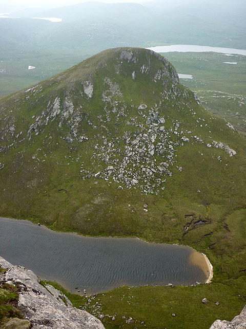 Photo could not load
NC5648 : Sgor Fhionnaich (568m)
Karl and Ali
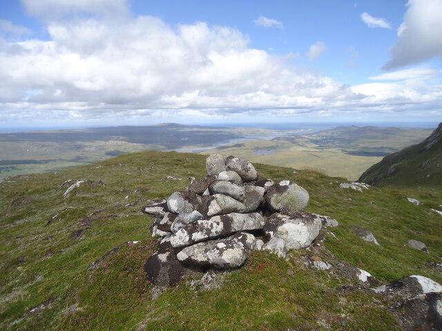 Photo could not load
NC5648 : The summit of Sgor Fhionnaich
Michael Earnshaw
Hill facts and local notes
Classifications
Elevation
568m
1,865 ft
Prominence
142m
Coordinates
58.3991, -4.4604
NC563482
OS Map
10
Explorer: 447S
At the Summit
The summit is marked by a sizeable cairn, providing a perfect spot for a well-deserved rest and a photo opportunity.
Terrain & Geology
Sgor Fhionnaich is primarily composed of schist and granite, typical for the region, with glacially carved features evident in the surrounding landscape. The geomorphology showcases classic Highland scenery, steep slopes, and distinctive corries.
Views & Scenery
From the summit, one can gaze over the vast expanses of the Scottish Highlands, with views of Ben Nevis to the south-west, the rugged peaks of the Northwest Highlands, and the stunning lochs dotting the landscape.
History & Heritage
Name Origin
The name 'Sgor Fhionnaich' loosely translates to 'The Peak of the Clear Waters,' reflecting the lochs and rivers that shape the region's beauty.
Historical Significance
As a Munro, it draws climbers from all over the UK and beyond, showcasing the rugged beauty and rich cultural history of the Scottish Highlands.
Getting There & Facilities
Check current local access restrictions, parking rules and transport timetables before travelling. These notes do not confirm public access to the summit.
Parking
There is a small car park at the Bealach a' Ghaill, suitable for around 10 vehicles. Arrive early in the day to avoid missing out on a space.
Public Transport
The nearest bus service runs from Fort William to Invergarry, from where a taxi can be arranged to reach the trailhead.
Nearby Facilities
Fort William offers a variety of cafes, restaurants, and public toilets. Ensure to stock up on essentials before heading out.
Safety Information
Known Hazards
- Be aware of rapidly changing weather conditions. Certain sections can be boggy, particularly after heavy rain, so sturdy footwear is recommended. Rocky outcrops near the summit can be slippery.
General Safety Tips
- Check weather conditions before setting out
- Carry appropriate clothing and equipment
- Let someone know your planned route
- Take a map, compass, and GPS device
- Carry emergency supplies: food, water, first aid kit, torch
Hills
Some common questions about the hills answered
Are there group walks up Sgor Fhionnaich?
Many walkers use Walkmates to join or organise walks with others. You can check for group walks around Sgor Fhionnaich through the maps
Are there other walkers around Sgor Fhionnaich?
Activity varies by location and time, but Walkmates lets you see whether others have shared walks or shown interest in this area. Find other people through the walking friends search walking friends for Sgor Fhionnaich search or of course create your own walk for Sgor Fhionnaich
Can I organise a walk to Sgor Fhionnaich?
Yes. If there aren’t any walks listed already, you can create a walk and make it available for others to join.
If you're signed up to Walkmates, you can create a walk to Sgor Fhionnaich.
How do I find a walk up this hill?
There are often multiple ways to walk this hill, depending on experience and route preference. Walkmates helps you explore walks and routes that others have shared.
Can I suggest a new route up Sgor Fhionnaich?
Yes. You can suggest or create routes to share with others. Walkmates focuses on the social side of walking, so routes are used to help people organise walks and explore areas together, rather than as detailed navigation tools or route libraries.
Other uses really appreciate knowledgeable walkers sharing their routes. Share your favourite route to Sgor Fhionnaich here
The is an error or something incorrect about this hill. How do I let you know?
We always strive to keep the information on Walkmates as accurate as possible. If you find an error, please let us know through the contact form and we'll aim to correct it as quickly as possible
Community Discussion
Comments
Location
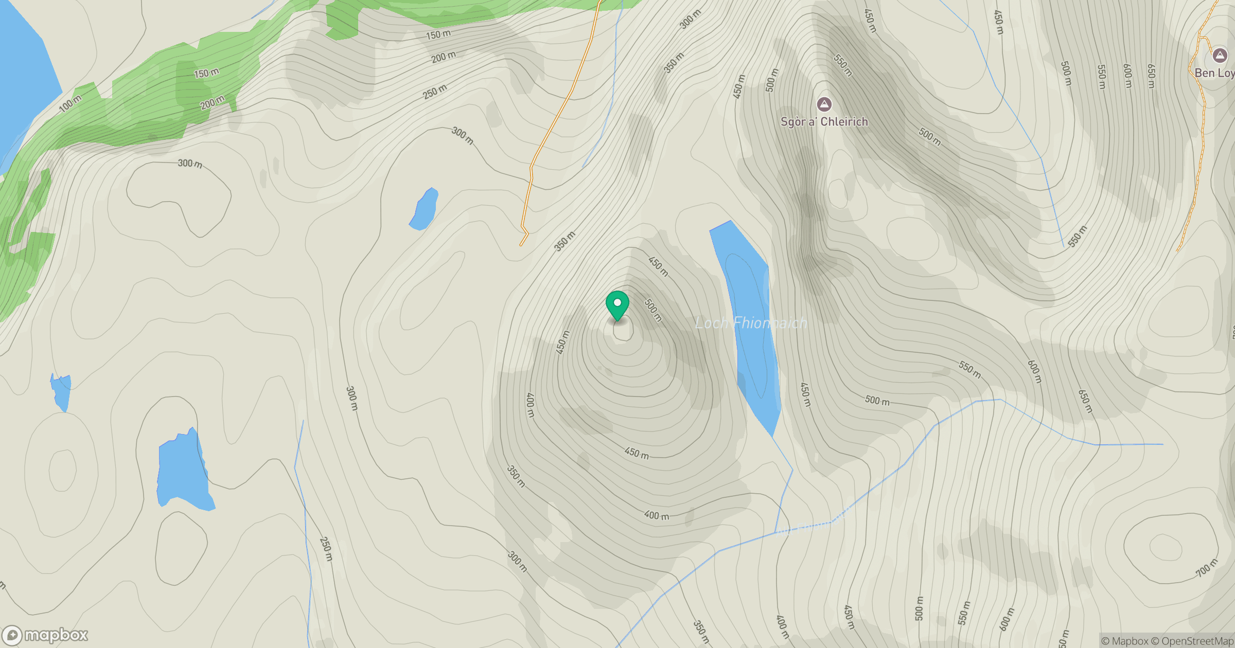
Grid reference: NC563482
View on OpenStreetMapOpens a map in a new tab, centred on the hill.
Hills within 30 km
Straight-line distance, not a walking route or confirmation of access.
No comments yet. Be the first.