
Mullyash Mountain
Good walks are even better shared.
Overview
Mullyash Mountain: A Hiker's Delight
Geology
Mullyash Mountain, in the stunning Southern Mourne Mountains, is primarily composed of granite. This rocky formation showcases a history shaped by glacial actions during the last Ice Age—thought to be as ancient as your grandparents’ stories. Don’t let that deter you; it’s also what gives Mullyash its spectacular views and dramatic landscape.
The Routes
One popular route is the 'Mullyash Passing', an approximately 7 km hike that offers breathtaking scenery as you meander through lush greenery and rocky outcrops. The path is well-trodden and, while moderate in difficulty, don’t forget to wear sturdy footwear unless you fancy turning your hike into an unplanned mud wrestling contest with Mother Nature.
Summit Features
Upon reaching the summit, the stone cairn awaits, ready to grace your photographs with its rustic charm. The trig point provides an excellent backdrop for those social media shots that need a dash of adventure.
Terrain Type
Be prepared for a rocky ascent with pockets of grass and some boggy areas towards the trails. Consider bringing a few baggies for your shoes, as you might find yourself dancing around a mud puddle or two!
Views
From atop Mullyash, the vistas are nothing short of awe-inspiring. The panoramic view includes the neighbouring Mourne Mountains, the shimmering Carlingford Lough, and if you squint just right, the Isle of Man on the horizon. Autumn or spring are the best seasons for these photo ops—nothing quite beats the foliage or wildflowers.
Hazards
Like all adventurous outings, keep an eye out for slippery rocks, sudden weather changes, and the cheeky sheep that may not appreciate your encroachment on their territory. It’s a wild world out there!
Access
Conveniently located near Hilltown, you can find parking along the road at no cost. Public transport options are available too; a bus can bring you near Hilltown, followed by a short taxi ride. After a delightful hike, enjoy the local cafes and possibly treat yourself to a well-deserved slice of cake.
History
The name 'Mullyash' means 'the lovely summit' in Irish, fitting for a peak as lovely as this one. It holds cultural significance, steeped in local lore and the myths of the Mourne Mountains. It’s a paradise for those looking to explore both nature and story.
So grab your boots, pack your snacks, and get ready to conquer Mullyash Mountain. It’s a journey worth taking!
Explore routes near Mullyash Mountain
Public walks starting within 80 km of this hill. Nearby does not mean a route reaches the summit; check its map and access before setting out.
Scarva to Poyntzpass: Newry Canal and Lough Shark Return
View route
Portadown to Knock Bridge: Bann Boulevard and Moneypenny’s Lock
View route
Peatlands Park Red Trail: Annagarriff Wood and Derryadd Lough
View route
Silent Valley to Ben Crom Dam: Reservoir Road Walk, County Down
View route
Route planning notes
These notes describe possible approaches, not verified navigable routes or permission to cross land. Check current paths, local access rules and conditions before setting out.
Mullyash Passing
A scenic route starting from the nearby road, taking you through lush valleys and up to the summit of Mullyash Mountain. Keep an eye out for friendly sheep along the way!
Make a day of it, together
Find someone to share the walk with, or organise a day out along a route you like.
Hill facts and local notes
Classifications
Elevation
317m
1,040 ft
Prominence
100m
Coordinates
54.1775, -6.6714
H868262
OS Map
28
At the Summit
The summit features a well-built stone cairn and a trig point, which is essentially a fancy way of saying a concrete pillar that loves to photo-bomb hikers' selfies.
Terrain & Geology
Mullyash Mountain is primarily composed of granite, giving it a rugged, rocky appearance. The mountain features glacially sculpted landscapes resulting from the last Ice Age, which is why it's often said to be as old as your dad's jokes.
Views & Scenery
From the summit, you can enjoy views of the surrounding Mourne Mountains, Carlingford Lough, and on a clear day, glimpse the coastline all the way to the Isle of Man. Not too shabby for a day out!
History & Heritage
Name Origin
The name 'Mullyash' derives from 'Mullach Aoibhinn', meaning 'the lovely summit' in Irish, and I think we can all agree it’s definitely living up to that name.
Historical Significance
Mullyash is rich in local folklore and history, often associated with the legends of the Mourne Mountains and their mythical guardians.
Getting There & Facilities
Check current local access restrictions, parking rules and transport timetables before travelling. These notes do not confirm public access to the summit.
Parking
There is parking available along the road near the start of the hiking trail, which is free and has enough space to accommodate several vehicles.
Public Transport
Buses run from Newry to the nearby village of Hilltown, followed by a short taxi ride to the trailhead.
Nearby Facilities
There are cafes and toilets available in Hilltown, making it a good stop before or after your expedition. Just be sure to fuel up on the local before you go tramping about.
Safety Information
Known Hazards
- Watch out for slippery rocks and sudden changes in weather. Additionally, livestock may be grazing and could have their own ideas about sharing the path.
General Safety Tips
- Check weather conditions before setting out
- Carry appropriate clothing and equipment
- Let someone know your planned route
- Take a map, compass, and GPS device
- Carry emergency supplies: food, water, first aid kit, torch
Hills
Some common questions about the hills answered
Are there group walks up Mullyash Mountain?
Many walkers use Walkmates to join or organise walks with others. You can check for group walks around Mullyash Mountain through the maps
Are there other walkers around Mullyash Mountain?
Activity varies by location and time, but Walkmates lets you see whether others have shared walks or shown interest in this area. Find other people through the walking friends search walking friends for Mullyash Mountain search or of course create your own walk for Mullyash Mountain
Can I organise a walk to Mullyash Mountain?
Yes. If there aren’t any walks listed already, you can create a walk and make it available for others to join.
If you're signed up to Walkmates, you can create a walk to Mullyash Mountain.
How do I find a walk up this hill?
There are often multiple ways to walk this hill, depending on experience and route preference. Walkmates helps you explore walks and routes that others have shared.
Can I suggest a new route up Mullyash Mountain?
Yes. You can suggest or create routes to share with others. Walkmates focuses on the social side of walking, so routes are used to help people organise walks and explore areas together, rather than as detailed navigation tools or route libraries.
Other uses really appreciate knowledgeable walkers sharing their routes. Share your favourite route to Mullyash Mountain here
The is an error or something incorrect about this hill. How do I let you know?
We always strive to keep the information on Walkmates as accurate as possible. If you find an error, please let us know through the contact form and we'll aim to correct it as quickly as possible
Community Discussion
Comments
Location
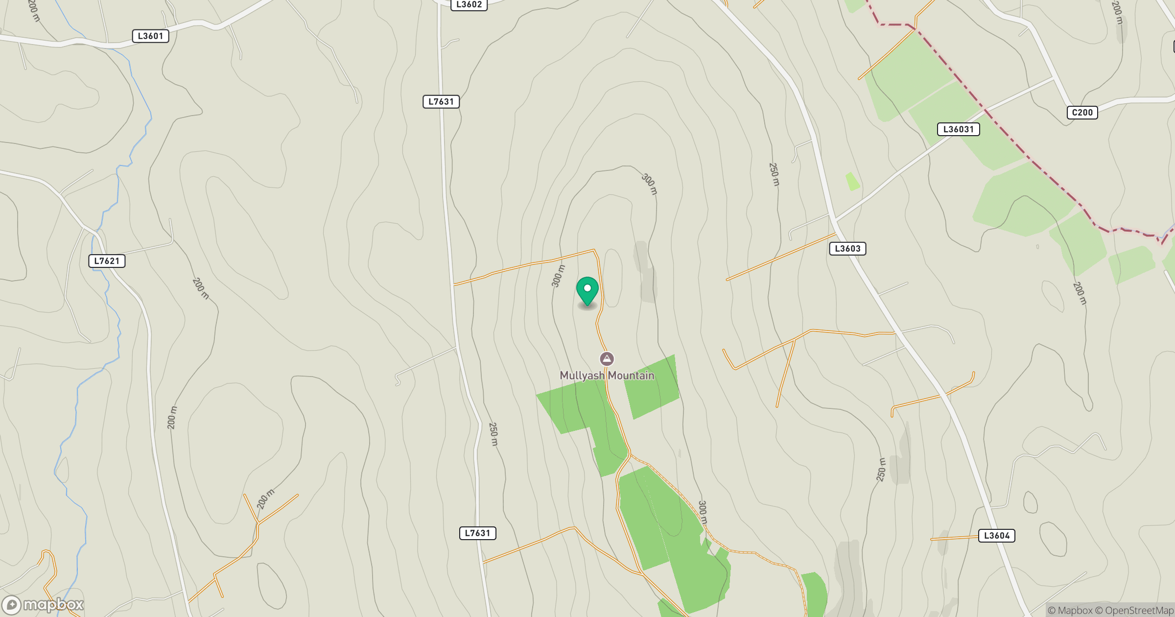
Grid reference: H868262
View on OpenStreetMapOpens a map in a new tab, centred on the hill.
Hills within 30 km
Straight-line distance, not a walking route or confirmation of access.
Slieve Gullion
576m
Carrigatuke
365m
Croslieve
308m
Tievecrom
263m
Camlough Mountain [Sliabh gCuircin]
423m
No comments yet. Be the first.