
Mount Kennedy
Good walks are even better shared.
Overview
Mount Kennedy
Elevating your hiking experience!
Mount Kennedy, towering at 794 metres, is a gem nestled in the Scottish Highlands, demanding respect but offering rewards for those who dare to ascend. As a Marilyn, it might not have the towering status of Ben Nevis, but it's got charm enough to make any hiker's heart flutter.
Geology
Mount Kennedy showcases some of the oldest geological formations in the region. The ancient volcanic activity has left behind dramatic structures that make for an interesting study—plus, they provide a perfect backdrop for those all-important selfie moments. Don't forget to look for basalt columns that look like nature’s own organ pipes!
Routes
The primary route to the summit is the Kennedy Ridge Path, covering approximately 6.5 km of delightful terrain. Starting at the small car park, the path features gentle gradients and picturesque views, making for an enjoyable day out.
Summit Features
At the summit, you’ll find a modest stone cairn, which seems to whisper tales of past adventurers who’ve savoured the panoramic views. Make sure you take a moment to appreciate the silent majesty of the Highlands that sprawls beneath your feet.
Terrain Type
Prepare for a varied landscape—some grassy patches, delightful heather, and a few rocky sections that add a bit of character to your hike. Good boots will ensure you stay upright and avoid an unceremonious tumble!
Views
From the top, the views are nothing short of spectacular. On a clear day, the distant Ben Nevis range greets you, complemented by the shimmering Loch Linnhe. The best time for these views is during the golden hours of early morning or late afternoon.
Hazards
Be aware that the weather can change as quickly as a sneeze—one moment it’s sunny, the next you might be dodging rain. Additionally, watch your step on those slippery rocks; they have indeed been known to cause mischief!
Nearby Summits
Mount Kennedy is in good company with nearby peaks such as Ben Nevis and Aonach Mòr, providing ample opportunities for further exploration and adventure.
Access
Getting to Mount Kennedy is as easy as pie—well, maybe not that easy. There's a small car park at the base, and Fort William is just a short drive away, offering public transport connections for those travelling without a car.
Facilities
If you’re in need of sustenance or a toilet break, Fort William is packed with cafes, restaurants, and public restrooms, ensuring you’re fully prepared for your trek.
History
The mountain’s namesake, John F. Kennedy, adds a charming historical context to your adventure. The link between Scotland and the USA is not only intriguing but also adds a beautiful layer of richness to your hike.
In summary, Mount Kennedy invites you to lace up your boots and join in on the adventure. Whether you're a solo hiker or dragging friends along, you're bound to find laughter and local beauty while gravitating towards this stunning Highland icon. Happy trekking!
Explore routes near Mount Kennedy
Public walks starting within 80 km of this hill. Nearby does not mean a route reaches the summit; check its map and access before setting out.
No public routes are currently listed within 80 km of Mount Kennedy on Walkmates. This does not mean there are no paths here. Explore the map and check local access information before planning a walk.
Route planning notes
These notes describe possible approaches, not verified navigable routes or permission to cross land. Check current paths, local access rules and conditions before setting out.
Kennedy Ridge Path
A scenic ascent along the Kennedy Ridge with gentle slopes and occasional rocky outcrops, providing a pleasant hike suitable for many.
Make a day of it, together
Find someone to share the walk with, or organise a day out along a route you like.
Hill facts and local notes
Classifications
Elevation
366m
1,200 ft
Prominence
138m
Coordinates
53.0784, -6.1468
O242046
OS Map
56
At the Summit
The summit boasts a small stone cairn, perfect for a quick photo op and perhaps a moment of reflection over the breathtaking surroundings.
Terrain & Geology
Mount Kennedy features ancient volcanic rock formations, primarily composed of basalt and andesite, giving it a rugged appearance. The mountain offers a fascinating glimpse into Scotland's geological past.
Views & Scenery
Panoramic views of the Ben Nevis range and across the lush valleys of the Highlands, with Loch Linnhe sparkling in the distance on a clear day.
History & Heritage
Name Origin
Mount Kennedy is named after John F. Kennedy, the 35th President of the United States, reflecting a historical nod to the friendship between Scotland and the USA.
Historical Significance
This mountain is not only a highlight for hikers but also holds a place in the hearts of history buffs eager to trace the American connection to Scottish roots.
Getting There & Facilities
Check current local access restrictions, parking rules and transport timetables before travelling. These notes do not confirm public access to the summit.
Parking
There is a small car park at the base of the Kennedy Ridge Path, accommodating around 15 vehicles. It's free, but it fills up quickly during peak seasons.
Public Transport
Nearest bus service can be accessed from Fort William, approximately 20 km away, which connects to regional services.
Nearby Facilities
Fort William offers various facilities, including cafes, pubs, and public toilets. It also serves as a great base for stocking up on supplies before your hike.
Safety Information
Known Hazards
- Sudden weather changes can occur, presenting visibility challenges. Slippery rocks can be found during wet weather, and wildlife, while beautiful, should be observed from a distance.
General Safety Tips
- Check weather conditions before setting out
- Carry appropriate clothing and equipment
- Let someone know your planned route
- Take a map, compass, and GPS device
- Carry emergency supplies: food, water, first aid kit, torch
Hills
Some common questions about the hills answered
Are there group walks up Mount Kennedy?
Many walkers use Walkmates to join or organise walks with others. You can check for group walks around Mount Kennedy through the maps
Are there other walkers around Mount Kennedy?
Activity varies by location and time, but Walkmates lets you see whether others have shared walks or shown interest in this area. Find other people through the walking friends search walking friends for Mount Kennedy search or of course create your own walk for Mount Kennedy
Can I organise a walk to Mount Kennedy?
Yes. If there aren’t any walks listed already, you can create a walk and make it available for others to join.
If you're signed up to Walkmates, you can create a walk to Mount Kennedy.
How do I find a walk up this hill?
There are often multiple ways to walk this hill, depending on experience and route preference. Walkmates helps you explore walks and routes that others have shared.
Can I suggest a new route up Mount Kennedy?
Yes. You can suggest or create routes to share with others. Walkmates focuses on the social side of walking, so routes are used to help people organise walks and explore areas together, rather than as detailed navigation tools or route libraries.
Other uses really appreciate knowledgeable walkers sharing their routes. Share your favourite route to Mount Kennedy here
The is an error or something incorrect about this hill. How do I let you know?
We always strive to keep the information on Walkmates as accurate as possible. If you find an error, please let us know through the contact form and we'll aim to correct it as quickly as possible
Community Discussion
Comments
Location
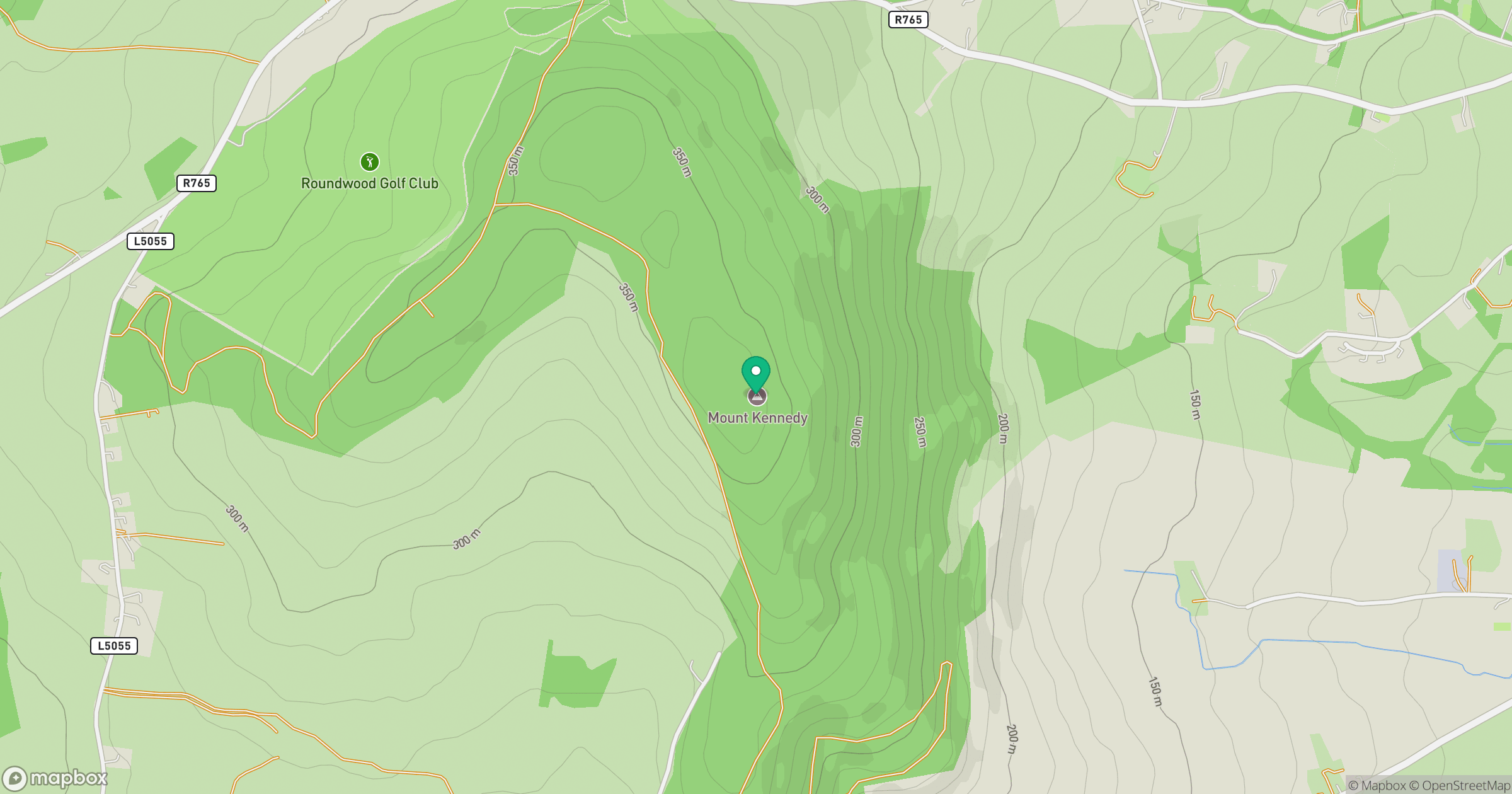
Grid reference: O242046
View on OpenStreetMapOpens a map in a new tab, centred on the hill.
Hills within 30 km
Straight-line distance, not a walking route or confirmation of access.
Mullaghcleevaun
847m
Lugnaquilla [Log na Coille]
925m
Great Sugar Loaf
501m
Little Sugar Loaf
342m
Ballinacorbeg
335m
No comments yet. Be the first.