
Ballinacorbeg
Good walks are even better shared.
Overview
Ballinacorbeg: The Hidden Gem of Wicklow Mountains
Nestled within the ruggedly beautiful Wicklow Mountains, Ballinacorbeg may not boast the height of its illustrious neighbours, but what it lacks in stature, it makes up for in charm and scenic views. At an elevation of 652 meters, it’s a prime spot for a day trip for both seasoned hikers and enthusiastic novices.
Geology
The geology of Ballinacorbeg is a narrative crafted over millennia. Composed predominantly of various schists, this area has been sculpted by glacial activity, forming the undulating landscape we see today. It’s a tale of the earth’s ancient past that invites hikers to take a closer look, just be careful not to trip over those rocks whilst mesmerised!
Routes
There are several routes to tackle Ballinacorbeg, with the most popular being the Ballinacorbeg Circuit. This enjoyable loop covers approximately 7.5 km, ideally suited to those seeking a moderate challenge amidst Ireland's natural beauty. For those with a bit more get-up-and-go, the Direct Ascent from the West offers a steeper climb but rewards mortality with breathtaking views of the expansive valleys below.
Terrain
Expect a little bit of everything—grassy slopes, rocky outcrops, and the occasional bog to keep you on your toes! Proper footwear is a must, lest you fancy the idea of sporting wet socks for the day.
Summit Features
At the summit, you’ll find a delightful stone cairn, a humble yet inspiring structure marking your accomplishment. On a clear day, the panoramic views are nothing short of spectacular, showcasing the rolling terrain and maybe even a glimpse of Dublin on the horizon.
Hazards
As with many hiking adventures in Ireland, be mindful of the weather. Conditions can change dramatically, leading to slippery paths. Stick to the trails to avoid getting stuck in the ever-feisty bogs!
Access
Ballinacorbeg is accessible via a small access road with limited parking, so pop those wheels into gear and get there early! Public transport options from Dublin take you to Rathdrum, where a taxi ride will bring you closer to the foot of the mountain—convenience at its finest!
Facilities
While facilities are sparse on the mountain itself, the charming town of Rathdrum provides all necessary amenities, including nourishing cafés to refill on caffeine after your trek.
History
The name “Ballinacorbeg” has origins tied to the local geography, meaning ‘the little town of the river’. It reflects the region’s agricultural past and hints at historical human settlements that have thrived in this landscape.
In conclusion, Ballinacorbeg is the kind of hill that whispers adventure to those willing to seek it. Whether you’re an intrepid hiker looking for solitude or someone who loves the thrill of nature, this mountain may just delight you to bits!
Happy hiking!
Explore routes near Ballinacorbeg
Public walks starting within 80 km of this hill. Nearby does not mean a route reaches the summit; check its map and access before setting out.
No public routes are currently listed within 80 km of Ballinacorbeg on Walkmates. This does not mean there are no paths here. Explore the map and check local access information before planning a walk.
Route planning notes
These notes describe possible approaches, not verified navigable routes or permission to cross land. Check current paths, local access rules and conditions before setting out.
Ballinacorbeg Circuit
A scenic circuit starting from the small access road south of the mountain. The trail encompasses both ascending and descending sections, providing a rounded experience of the terrain.
Direct Ascent from the West
A shorter, more direct ascent leading up from the nearby forested areas, offering a steep climb but rewarding views at the summit.
Make a day of it, together
Find someone to share the walk with, or organise a day out along a route you like.
Hill facts and local notes
Classifications
Elevation
335m
1,099 ft
Prominence
100m
Coordinates
53.0397, -6.2356
O184002
OS Map
56
At the Summit
The summit features a small stone cairn and a spectacular 360-degree view of the surrounding hills and valleys.
Terrain & Geology
The area features metamorphic rocks primarily composed of schist, with glacially sculpted features adding a dramatic landscape. These geological characteristics date back to the Caledonian orogeny and are rich in mineral deposits.
Views & Scenery
From the summit, hikers can see the picturesque Lough Dan to the south and a sweeping vista of the Wicklow Mountains. On clear days, the Dublin and Irish Sea coastlines can be glimpsed in the distance.
History & Heritage
Name Origin
The name 'Ballinacorbeg' roughly translates to 'the little town of the river', reflecting the terrain and history of settlements in the area.
Historical Significance
Historically, this region was important for agriculture and has remnants of ancient pathways and settlements that testify to its long-standing human occupation.
Getting There & Facilities
Check current local access restrictions, parking rules and transport timetables before travelling. These notes do not confirm public access to the summit.
Parking
Parking is available at the end of the access road near the start of the trails. Parking space is limited, so arrive early to secure a spot.
Public Transport
The nearest bus stop is in the village of Glendalough, which is serviced by local routes from Dublin. A taxi can be arranged from there.
Nearby Facilities
Facilities are available in Rathdrum, including cafes, shops, and public toilets. It's advisable to bring your own supplies.
Safety Information
Known Hazards
- Potential for slippery conditions in wet weather. Ensure to stay on marked trails to avoid getting bogged down in marshy areas.
General Safety Tips
- Check weather conditions before setting out
- Carry appropriate clothing and equipment
- Let someone know your planned route
- Take a map, compass, and GPS device
- Carry emergency supplies: food, water, first aid kit, torch
Hills
Some common questions about the hills answered
Are there group walks up Ballinacorbeg?
Many walkers use Walkmates to join or organise walks with others. You can check for group walks around Ballinacorbeg through the maps
Are there other walkers around Ballinacorbeg?
Activity varies by location and time, but Walkmates lets you see whether others have shared walks or shown interest in this area. Find other people through the walking friends search walking friends for Ballinacorbeg search or of course create your own walk for Ballinacorbeg
Can I organise a walk to Ballinacorbeg?
Yes. If there aren’t any walks listed already, you can create a walk and make it available for others to join.
If you're signed up to Walkmates, you can create a walk to Ballinacorbeg.
How do I find a walk up this hill?
There are often multiple ways to walk this hill, depending on experience and route preference. Walkmates helps you explore walks and routes that others have shared.
Can I suggest a new route up Ballinacorbeg?
Yes. You can suggest or create routes to share with others. Walkmates focuses on the social side of walking, so routes are used to help people organise walks and explore areas together, rather than as detailed navigation tools or route libraries.
Other uses really appreciate knowledgeable walkers sharing their routes. Share your favourite route to Ballinacorbeg here
The is an error or something incorrect about this hill. How do I let you know?
We always strive to keep the information on Walkmates as accurate as possible. If you find an error, please let us know through the contact form and we'll aim to correct it as quickly as possible
Community Discussion
Comments
Location
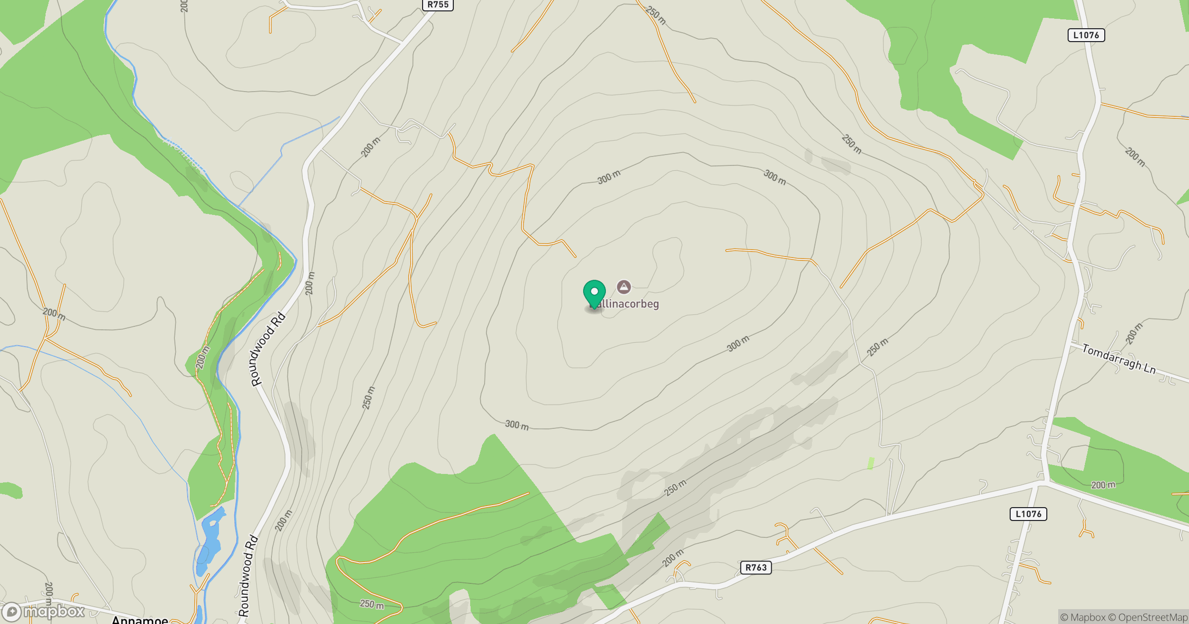
Grid reference: O184002
View on OpenStreetMapOpens a map in a new tab, centred on the hill.
Hills within 30 km
Straight-line distance, not a walking route or confirmation of access.
Mullaghcleevaun
847m
Lugnaquilla [Log na Coille]
925m
Trooperstown Hill [Maoilin]
430m
Knocknacloghoge
532m
Scarr
640m
No comments yet. Be the first.