
Mount Corrin
Good walks are even better shared.
Overview
Mount Corrin
Overview
Mount Corrin is a charming Marilyn located in the breathtaking Scottish Highlands, standing at an elevation of 453 meters. Its approachable trails, picturesque views, and unique geological features make it a popular choice for outdoor enthusiasts.
Geology
Composed mainly of resilient granite, Mount Corrin has stood the test of time, offering both beauty and challenge to hikers. The granite formations produce dramatic cliffs and rocky outcrops, creating a stunning backdrop for perfect Instagram moments.
Routes
The Corrin Hill Trail is the most popular route to the summit. This 4.5 km hike typically requires around two hours to complete, making it suitable for families or those looking for a moderate day's outing. The path winds through fragrant heather and offers plenty of resting spots to catch your breath (and the views!).
Summit Features
Reaching the summit, hikers will encounter a notable cairn, which serves as a proud testament to the feet of many adventurers. Rest assured, this isn't just a pile of rocks; it’s a monument of triumph!
Terrain
Expect a varied terrain that includes rocky outcrops and grassy paths. The initial gentle slopes soon turn into more challenging ascents that will get your heart racing, in a good way!
Views
On clear days, the views from the summit are simply brilliant. Look out towards Ben Nevis, the UK's highest peak, and the shimmering waters of Loch Ness, which may (or may not) house the legend itself. Late spring and early autumn are the best times to visit, as the weather usually cooperates, revealing unfathomable beauty.
Hazards
As with any mountain, caution is advised. Slippery rocks and sudden weather changes can pose risks. Make sure you've got a sturdy pair of boots and a firm grip on your walking stick to avoid awkward tumbles.
Access
The nearest parking is conveniently located near the trailhead in Invermoriston, allowing approximately 10 vehicles. If you’re coming by bus, services run regularly from Inverness, making it easy to reach your hiking destination without the fuss of a car ride.
Facilities
Invermoriston, the friendly village nearby, boasts small cafes and public toilets, perfect for fuelling up before your hike or unwinding afterwards with a well-deserved slice of cake.
History
The name 'Corrin' reflects its Gaelic origins, signifying 'hollow' or 'cauldron' – a fitting description for the mountain’s unique shape. As a historical landmark, it has played an important role in marking boundaries for local clans throughout the ages.
In conclusion, Mount Corrin is not just a hike; it's an adventure steeped in natural beauty and rich history. Don’t forget your camera, your sense of adventure, and perhaps a snack or two for the summit!
Explore routes near Mount Corrin
Public walks starting within 80 km of this hill. Nearby does not mean a route reaches the summit; check its map and access before setting out.
No public routes are currently listed within 80 km of Mount Corrin on Walkmates. This does not mean there are no paths here. Explore the map and check local access information before planning a walk.
Route planning notes
These notes describe possible approaches, not verified navigable routes or permission to cross land. Check current paths, local access rules and conditions before setting out.
Corrin Hill Trail
A well-defined path that meanders through heather-covered slopes before ascending more steeply towards the summit. Suitable for families with a bit of stamina!
Make a day of it, together
Find someone to share the walk with, or organise a day out along a route you like.
Hill facts and local notes
Classifications
Elevation
284m
932 ft
Prominence
117m
Coordinates
51.5942, -9.5275
V942390
OS Map
88
At the Summit
The summit features a prominent cairn that acts as a beacon for weary hikers, along with stunning panoramic views of the surrounding landscape.
Terrain & Geology
Mount Corrin is primarily composed of granite, a resilient rock that has weathered beautifully over centuries. This gives the mountain its striking features and steep faces, making it a delight for both climbers and photographers alike.
Views & Scenery
From the summit, one can feast their eyes on Ben Nevis to the south and the deep blue of Loch Ness, possibly even catching sight of a Loch Ness Monster (or just a log, your call!).
History & Heritage
Name Origin
The name 'Corrin' derives from the Gaelic 'Coire', meaning 'hollow' or 'cauldron', probably referring to the distinctive bowl shape of the mountain's slopes.
Historical Significance
This mountain has been a notable landmark for local clans throughout history, seen as a marker of territorial boundaries in centuries gone by.
Getting There & Facilities
Check current local access restrictions, parking rules and transport timetables before travelling. These notes do not confirm public access to the summit.
Parking
There is a small parking area at the start of the Corrin Hill Trail, located near the village of Invermoriston, accommodating approximately 10 vehicles.
Public Transport
Regular bus services run from Inverness to Invermoriston, making it relatively straightforward for those relying on public transport.
Nearby Facilities
In Invermoriston, you'll find a few quaint cafes and public toilets, perfect for a pit stop before or after your hiking adventure.
Safety Information
Known Hazards
- Watch out for slippery rocks, especially after rain. Also, strong winds can occur at higher elevations, so it’s advisable to keep a firm hold on your hat – and your wits!
General Safety Tips
- Check weather conditions before setting out
- Carry appropriate clothing and equipment
- Let someone know your planned route
- Take a map, compass, and GPS device
- Carry emergency supplies: food, water, first aid kit, torch
Hills
Some common questions about the hills answered
Are there group walks up Mount Corrin?
Many walkers use Walkmates to join or organise walks with others. You can check for group walks around Mount Corrin through the maps
Are there other walkers around Mount Corrin?
Activity varies by location and time, but Walkmates lets you see whether others have shared walks or shown interest in this area. Find other people through the walking friends search walking friends for Mount Corrin search or of course create your own walk for Mount Corrin
Can I organise a walk to Mount Corrin?
Yes. If there aren’t any walks listed already, you can create a walk and make it available for others to join.
If you're signed up to Walkmates, you can create a walk to Mount Corrin.
How do I find a walk up this hill?
There are often multiple ways to walk this hill, depending on experience and route preference. Walkmates helps you explore walks and routes that others have shared.
Can I suggest a new route up Mount Corrin?
Yes. You can suggest or create routes to share with others. Walkmates focuses on the social side of walking, so routes are used to help people organise walks and explore areas together, rather than as detailed navigation tools or route libraries.
Other uses really appreciate knowledgeable walkers sharing their routes. Share your favourite route to Mount Corrin here
The is an error or something incorrect about this hill. How do I let you know?
We always strive to keep the information on Walkmates as accurate as possible. If you find an error, please let us know through the contact form and we'll aim to correct it as quickly as possible
Community Discussion
Comments
Location
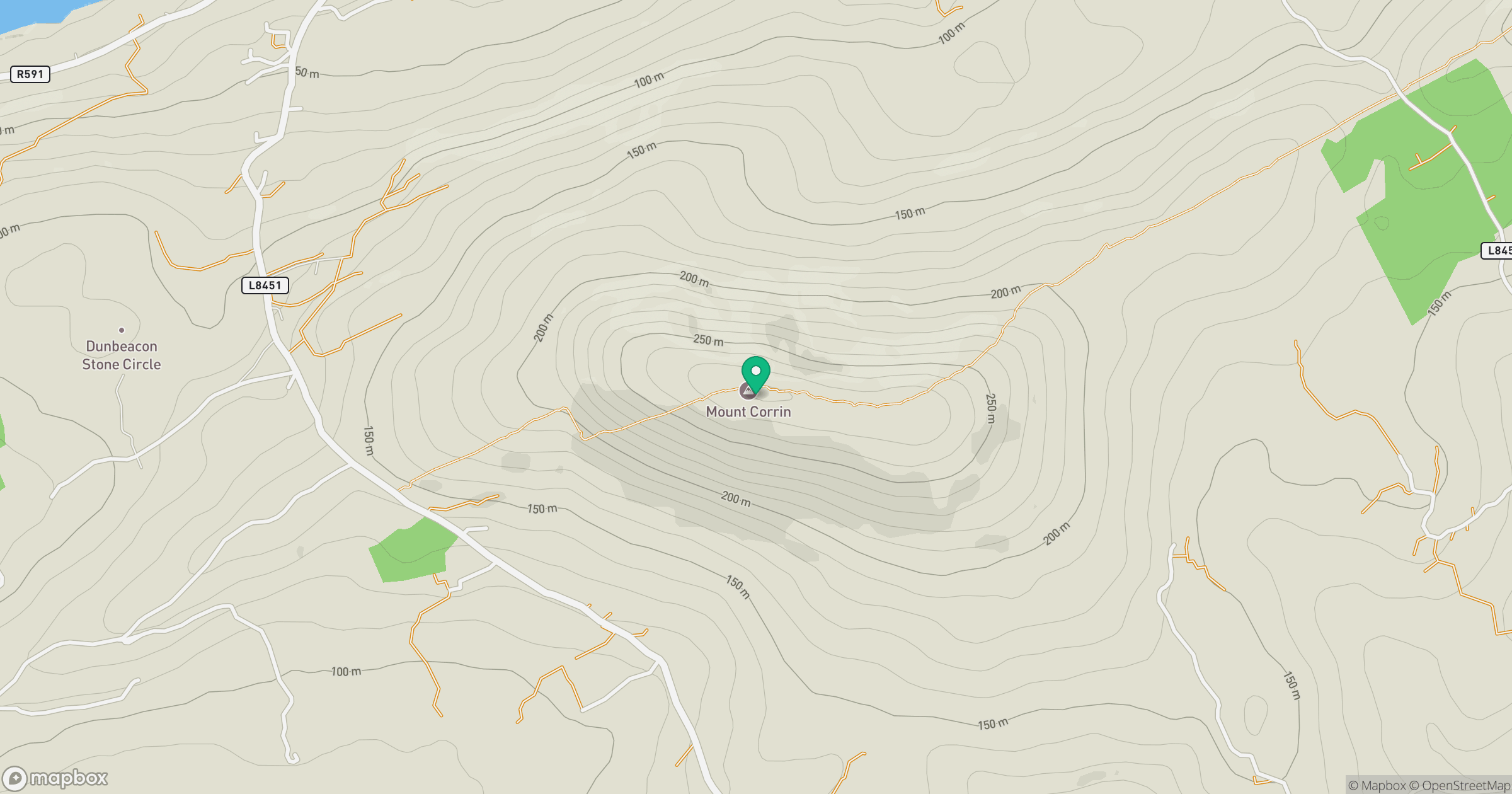
Grid reference: V942390
View on OpenStreetMapOpens a map in a new tab, centred on the hill.
Hills within 30 km
Straight-line distance, not a walking route or confirmation of access.
No comments yet. Be the first.