
Knockaughna
Good walks are even better shared.
Overview
Knockaughna: The Lesser-Known Gem of County Kerry
Location and Overview
Nestled in the picturesque County Kerry, Knockaughna stands at a respectable 456 meters, making it a delightful destination for those willing to take the road less travelled.
Geology
Composed primarily of ancient Cambrian rock, hikers can marvel at formations dating back over 500 million years. A geologist's paradise lies in these rugged outcrops!
Routes
The Knockaughna Circular Route is the most frequented path, spanning roughly 8 km and taking an estimated 3 hours to complete. This moderate trek offers both physical activity and stunning views. Roll on, hiking boots!
Summit Features
At the peak, you'll encounter a quaint cairn that offers a sense of accomplishment (and a great spot for those all-important summit selfies).
Terrain
Expect grassy slopes intertwined with rocky areas and patches of bog. A tip: wear old boots—you might just end up washing your shoes in more than just river water!
Views
From the summit, gaze out over the breathtaking Slieve Mish Mountains and the shimmering Tralee Bay. The patchwork of green fields below is truly spectacular, especially on clear days during late spring and early autumn.
Hazards
Keep your wits about you, as the weather can change faster than a cat on a hot tin roof. Plus, the boggy ground will test your footwear's mettle—be prepared for a squelchy surprise!
Access and Facilities
Parking in Knocknagoshel is quite limited, but there are options along the roadside. Taxis can be arranged from Tralee, the closest town, which offers ample facilities, including a shop and a pub to refuel after your hike.
History
Knockaughna’s name has roots in the Gaelic language, meaning 'hill of the marsh', an apt description of its heritage. The mountain holds cultural significance that reflects the ancient Gaelic way of life.
So there you have it: if you’re in the mood for a delightful adventure away from the usual crowds, Knockaughna beckons with open arms and, if you’re lucky, plenty of stunning views to boot! Happy hiking!
Explore routes near Knockaughna
Public walks starting within 80 km of this hill. Nearby does not mean a route reaches the summit; check its map and access before setting out.
No public routes are currently listed within 80 km of Knockaughna on Walkmates. This does not mean there are no paths here. Explore the map and check local access information before planning a walk.
Route planning notes
These notes describe possible approaches, not verified navigable routes or permission to cross land. Check current paths, local access rules and conditions before setting out.
Knockaughna Circular Route
A scenic circular route starting from the village of Knocknagoshel, offering a good mix of trails and beautiful views.
Make a day of it, together
Find someone to share the walk with, or organise a day out along a route you like.
Hill facts and local notes
Classifications
Elevation
268m
879 ft
Prominence
100m
Coordinates
51.5708, -9.5959
V894365
OS Map
88
At the Summit
The summit is marked by a small rocky outcrop and a sturdy cairn, perfect for snapping that Instagram-worthy pic.
Terrain & Geology
The mountain is composed of ancient Cambrian rocks, formed over 500 million years ago, offering a fascinating glimpse into the geological history of Ireland.
Views & Scenery
Stunning views of the Slieve Mish Mountains and Tralee Bay can be enjoyed from the top, with a sprawling tapestry of green fields in between.
History & Heritage
Name Origin
The name 'Knockaughna' is derived from the Gaelic 'Cnoc Aighne', meaning 'hill of the marsh', hinting at its boggy surroundings.
Historical Significance
The area has historical ties to ancient Gaelic settlements and offers a cultural richness that is often overlooked.
Getting There & Facilities
Check current local access restrictions, parking rules and transport timetables before travelling. These notes do not confirm public access to the summit.
Parking
There is limited parking available in Knocknagoshel, with roadside options being your best bet. Arrive early to secure a good spot!
Public Transport
Public transport is limited, but local buses to Tralee can get you part of the way. Taxis can be arranged from the town.
Nearby Facilities
The village of Knocknagoshel has a local shop and pub, where hikers can grab a bite to eat or a refreshing pint after conquering the mountain.
Safety Information
Known Hazards
- Beware of sudden weather changes, as conditions can shift quickly in the mountains. Also, watch out for boggy ground that can unexpectedly swallow your boots!
General Safety Tips
- Check weather conditions before setting out
- Carry appropriate clothing and equipment
- Let someone know your planned route
- Take a map, compass, and GPS device
- Carry emergency supplies: food, water, first aid kit, torch
Hills
Some common questions about the hills answered
Are there group walks up Knockaughna?
Many walkers use Walkmates to join or organise walks with others. You can check for group walks around Knockaughna through the maps
Are there other walkers around Knockaughna?
Activity varies by location and time, but Walkmates lets you see whether others have shared walks or shown interest in this area. Find other people through the walking friends search walking friends for Knockaughna search or of course create your own walk for Knockaughna
Can I organise a walk to Knockaughna?
Yes. If there aren’t any walks listed already, you can create a walk and make it available for others to join.
If you're signed up to Walkmates, you can create a walk to Knockaughna.
How do I find a walk up this hill?
There are often multiple ways to walk this hill, depending on experience and route preference. Walkmates helps you explore walks and routes that others have shared.
Can I suggest a new route up Knockaughna?
Yes. You can suggest or create routes to share with others. Walkmates focuses on the social side of walking, so routes are used to help people organise walks and explore areas together, rather than as detailed navigation tools or route libraries.
Other uses really appreciate knowledgeable walkers sharing their routes. Share your favourite route to Knockaughna here
The is an error or something incorrect about this hill. How do I let you know?
We always strive to keep the information on Walkmates as accurate as possible. If you find an error, please let us know through the contact form and we'll aim to correct it as quickly as possible
Community Discussion
Comments
Location
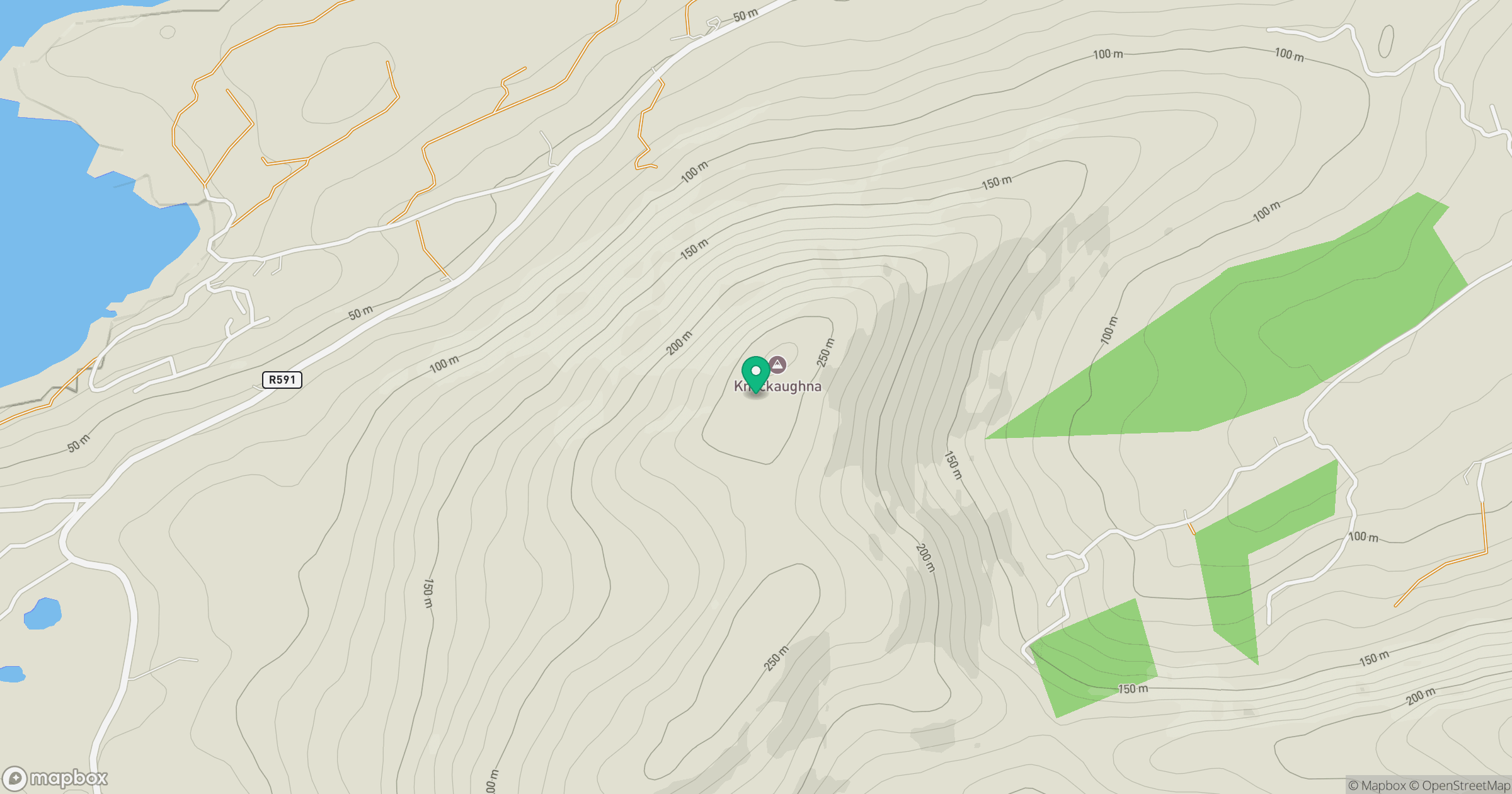
Grid reference: V894365
View on OpenStreetMapOpens a map in a new tab, centred on the hill.
Hills within 30 km
Straight-line distance, not a walking route or confirmation of access.
No comments yet. Be the first.