

Meall an Damhain
Good walks are even better shared.
Overview
Meall an Damhain
Overview
Meall an Damhain, standing tall at 716 meters, is a hidden gem in the Scottish Highlands. Its Marilyn classification indicates a notable prominence, making it a worthy objective for hikers looking for breathtaking views and less crowded trails.
Geology
Given its schist foundation, geologists and curious minds will find the rock formations fascinating. The interplay of weathering processes over time has created unique landscapes that are integral to the Highland scenery.
Route Details
The Badrallach Trail offers a well-marked path that is a blend of natural beauty and moderate challenge. The route leads through enchanting woodlands and opens up to scenic vistas as you approach the summit. A good pair of walking boots and a sense of adventure are all you need!
Summit Features
At the summit, you’ll find a robust cairn that’s an ideal spot to rest, regroup, and take a few photos. Just don’t forget your camera; the views would make your Instagram followers green with envy!
Terrain
Expect a mix of grassy inclines and rocky sections. The occasional boggy area can test your navigating skills, but hey, what's a little adventure without a splash of mud?
Views
A trek up Meall an Damhain rewards you with splendid views of the mighty An Teallach and Loch Broom, especially stunning during the golden hour of sunrise or sunset.
Hazards
As with any Highland trek, be cautious of rapidly changing weather; clouds can roll in with little warning. Also, take care on the rocky paths—they can be slippery, and no one wants an unexpected tumble!
Nearby Summits
While you’re in the area, consider bagging Ben Wyvis or An Teallach. Both offer their unique marvels and are just a stroll (or a bit of a drive) away.
Access
Parking is available at Badrallach, but don’t be surprised if it’s busy during peak season. Public transport options exist, but check local timetables to avoid waiting in the rain.
Facilities and History
Post-hike, head to Ullapool for refreshments and a bite to eat. The village is rich in Highland charm and history. You might find yourself lingering longer than planned.
Conclusion
In summary, Meall an Damhain is more than just a hill; it’s an experience waiting to be discovered. Whether you’re after solitude or spectacular scenery, you’ll find it here, albeit with a few wee bogs to navigate along the way!
Happy hiking, and don’t forget to respect your surroundings. Nature has its own way of looking after itself, and we’re just visitors!
Explore routes near Meall an Damhain
Public walks starting within 80 km of this hill. Nearby does not mean a route reaches the summit; check its map and access before setting out.
Ben Nevis via Mountain Path
View route
Banavie to Glen Loy Aqueduct: Neptune’s Staircase Canal Towpath
View route
Crinan Canal: Bellanoch and Dunardry towpath return
View route
West Highland Way: Tyndrum to Bridge of Orchy
View route
Route planning notes
These notes describe possible approaches, not verified navigable routes or permission to cross land. Check current paths, local access rules and conditions before setting out.
Badrallach Trail
A rewarding route that traverses through native woodlands and open moorland before the final ascent to the summit. Ideal for those looking to soak in the landscape.
Make a day of it, together
Find someone to share the walk with, or organise a day out along a route you like.
Photo Gallery
View all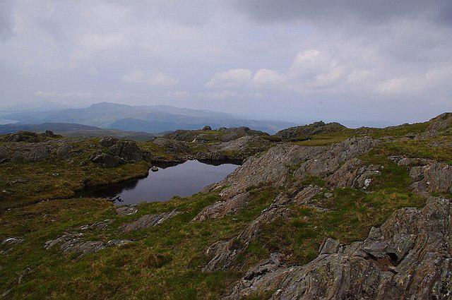 Photo could not load
NM7259 : A tiny lochan on Meall an Damhain
Pat Macleod
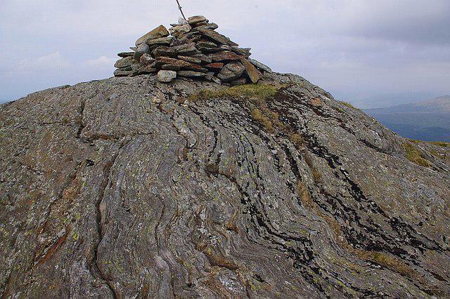 Photo could not load
NM7259 : The summit cairn on Meall an Damhain
Pat Macleod
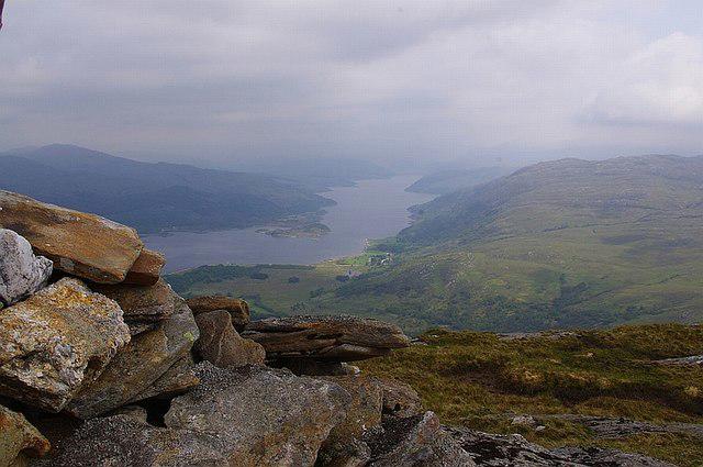 Photo could not load
NM7259 : Laudale and Loch Sunart from Meall an Damhain
Pat Macleod
Hill facts and local notes
Classifications
Elevation
519m
1,703 ft
Prominence
111m
Coordinates
56.6709, -5.7205
NM721594
OS Map
49
Explorer: 383E 383W
At the Summit
The summit features a small rocky outcrop and a sizable cairn, with a delightful view of the surrounding mountains and glens. It’s a perfect spot for a well-deserved snack break, making it a great photo opportunity.
Terrain & Geology
Primarily composed of schist, with some granite intrusions, Meall an Damhain offers a varied and intriguing geological landscape that showcases the processes that shaped the Scottish Highlands over millions of years.
Views & Scenery
From the summit, enjoy panoramic views of Loch Broom, the distant peaks of An Teallach, and the rugged beauty of the surrounding glens.
History & Heritage
Name Origin
The name 'Meall an Damhain' translates to 'Hill of the Stag', suggesting wildlife-rich surroundings that delighted local hunters.
Historical Significance
Like many peaks in Scotland, it holds cultural significance in local folklore, being associated with tales of Highland warriors and the local reverence for nature.
Getting There & Facilities
Check current local access restrictions, parking rules and transport timetables before travelling. These notes do not confirm public access to the summit.
Parking
There is a small car park at Badrallach, approximately 4 km from the trailhead. It fills up quickly during peak hiking season, so arriving early is advised.
Public Transport
Buses run from Inverness to Ullapool, with connections available to Badrallach. However, be prepared for some walking from the bus stop to the trailhead.
Nearby Facilities
Ullapool has a variety of cafes and shops, including restrooms and eateries for pre-hike breakfast or post-hike treat. It’s worth exploring the town if you have the time.
Safety Information
Known Hazards
- Beware of sudden weather changes typical of the Highlands, especially fog and rain; ensure you’re adequately prepared. Rocky sections can be slippery when wet, and bogs can be deceivingly deep.
General Safety Tips
- Check weather conditions before setting out
- Carry appropriate clothing and equipment
- Let someone know your planned route
- Take a map, compass, and GPS device
- Carry emergency supplies: food, water, first aid kit, torch
Hills
Some common questions about the hills answered
Are there group walks up Meall an Damhain?
Many walkers use Walkmates to join or organise walks with others. You can check for group walks around Meall an Damhain through the maps
Are there other walkers around Meall an Damhain?
Activity varies by location and time, but Walkmates lets you see whether others have shared walks or shown interest in this area. Find other people through the walking friends search walking friends for Meall an Damhain search or of course create your own walk for Meall an Damhain
Can I organise a walk to Meall an Damhain?
Yes. If there aren’t any walks listed already, you can create a walk and make it available for others to join.
If you're signed up to Walkmates, you can create a walk to Meall an Damhain.
How do I find a walk up this hill?
There are often multiple ways to walk this hill, depending on experience and route preference. Walkmates helps you explore walks and routes that others have shared.
Can I suggest a new route up Meall an Damhain?
Yes. You can suggest or create routes to share with others. Walkmates focuses on the social side of walking, so routes are used to help people organise walks and explore areas together, rather than as detailed navigation tools or route libraries.
Other uses really appreciate knowledgeable walkers sharing their routes. Share your favourite route to Meall an Damhain here
The is an error or something incorrect about this hill. How do I let you know?
We always strive to keep the information on Walkmates as accurate as possible. If you find an error, please let us know through the contact form and we'll aim to correct it as quickly as possible
Community Discussion
Comments
Location
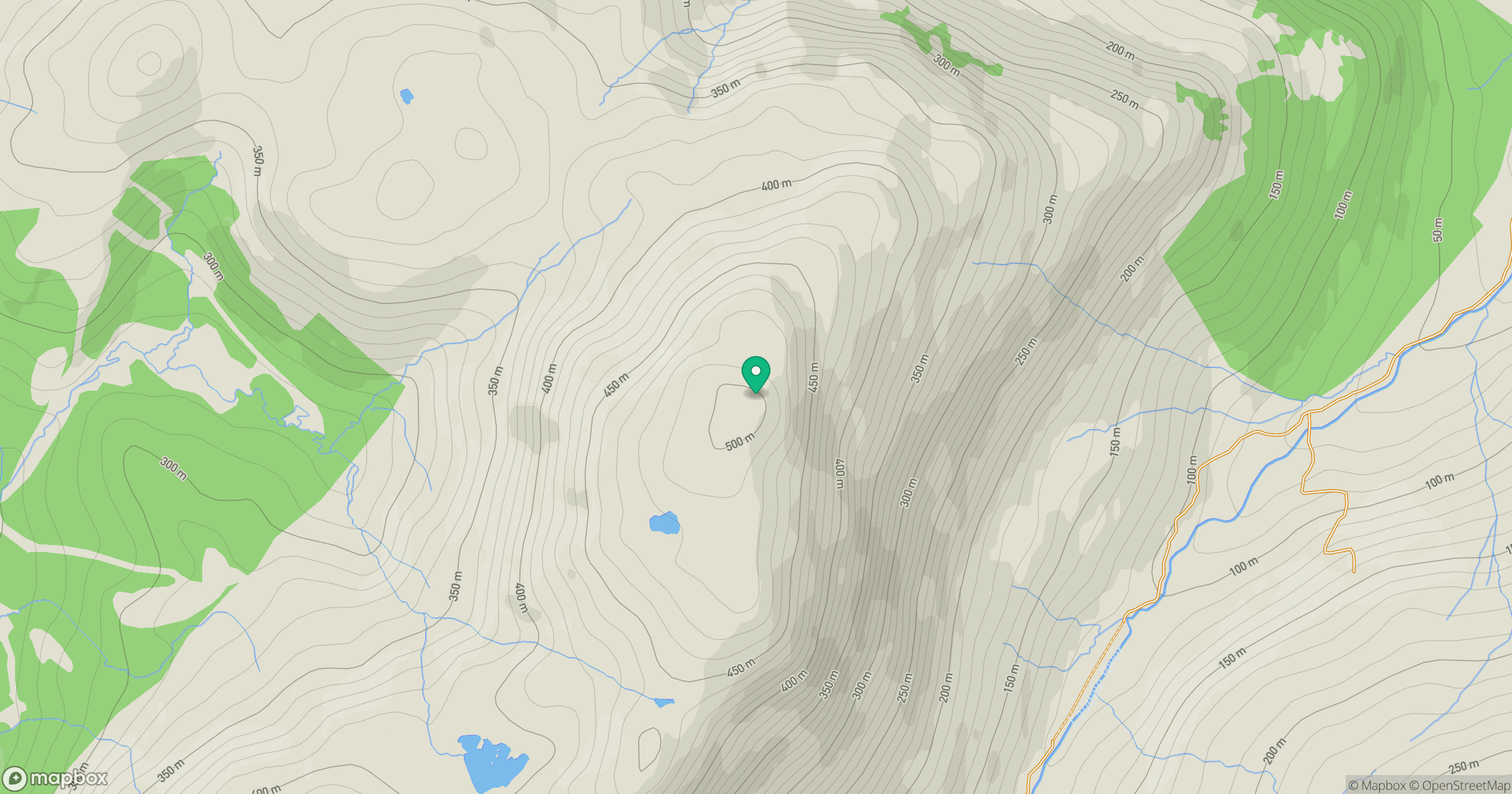
Grid reference: NM721594
View on OpenStreetMapOpens a map in a new tab, centred on the hill.
Hills within 30 km
Straight-line distance, not a walking route or confirmation of access.
Beinn Mheadhoin
739m
Sgurr Dearg
741m
Beinn nam Beathrach
582m
Beinn Iadain
571m
Beinn Chlaonleud
479m
No comments yet. Be the first.