

Maolan Bui
Good walks are even better shared.
V8383 : The ridge towards Maolan Bui and Cnoc an Chuillinn from Cnoc na Peiste
Colin Park Photo source
Overview
Maolan Bui
Welcome to Maolan Bui, a charming Marilyn located in the stunning Scottish Highlands. Standing at an elevation of 579 meters, this hill is known for its captivating views and solid granite terrain. To get here, all you need is a sense of adventure and possibly a good pair of walking boots—don’t forget those!
Geology
Maolan Bui is primarily composed of ancient granite, a hardy rock that sculpted the landscape over millions of years. Think of it as nature's very own stubborn artist, refusing to succumb to the wear and tear of time. The formations visible on your hike tell a geological tale that dates back to a time when this area was covered in volcanic activity!
Routes
There are a couple of popular routes you'll want to consider:
East Ridge Route
- Distance: 6.5 km
- Time: Approximately 2.5 hours
- Difficulty: Moderate
- This well-marked path cuts through serene woodlands before leading you to the rocky summit.
South Slopes Trail
- Distance: 7.2 km
- Time: About 3 hours
- Difficulty: Challenging
- A quieter path, this trail offers astounding views but gets a bit steeper near the top. Perfect for those who enjoy a good sweat!
Summit Features
The summit is a delightful rocky outcrop sporting a well-crafted cairn. It almost feels like a congratulatory hug from nature after your climb. And the panoramic view? Simply put, it’s one that will make you want to take a thousand photos—or at least a good few selfies!
Terrain
The terrain around Maolan Bui features a mix of rocky outcrops alongside inviting grassy patches. Be prepared for a bit of off-roading, but nothing that a well-placed footstep can’t handle!
Views
Once you reach the summit, the views will make any effort seem like a stroll in the park. You can feast your eyes on landmarks such as Ben Nevis and Loch Awe, their beauty only rivalled by the Highland cow’s seemingly indifferent expression as it munches away nearby. The best time to catch these views? Late spring or early autumn, when the air is crisp, and the scenery is bursting with colour.
Hazards
While the hike is quite rewarding, be mindful of loose rocks on your ascent and sudden weather changes. It wouldn’t be wise to tempt fate by waltzing along the trail after a heavy downpour.
Access
You can park a few minutes away from the trailhead in a charming little gravel parking area off the A85. Public transport is also conveniently available, with regular bus services from nearby Fort William to the village of Dalavich.
Facilities
In the village of Dalavich, you can find a small shop, a cozy café, and public toilets—handy for when you’re required to say goodbye to a coffee, if you know what I mean.
History
Maolan Bui translates to 'Yellow Hill', hinting at the beautiful hues this hill offers during certain seasons. Additionally, the area has a rich history tied to the Highland Clearances, with old trails still echoing tales of the clans that once roamed these hills.
So pack your bags, lace up those boots, and get ready for an adventure at Maolan Bui—it’s one for the books! Whatever you do, don’t forget your camera, as the views are too good to miss.
Happy hiking!
Explore routes near Maolan Bui
Walks starting near this hill. Open a route to check its map, distance and full itinerary.
Route planning notes
These notes describe possible approaches. Check a route's map and access information when planning your walk.
East Ridge Route
A well-marked path starting from the base of the hill, leading hikers through picturesque woodlands before ascending to the summit.
South Slopes Trail
This trail is less travelled but offers stunning views of the surrounding countryside. It follows gentle slopes before steepening towards the peak.
Make a day of it, together
Find someone to share the walk with, or organise a day out along a route you like.
Photo Gallery
View all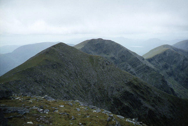 Photo could not load
V8383 : The ridge towards Maolan Bui and Cnoc an Chuillinn from Cnoc na Peiste
Colin Park
Hill facts and local notes
Classifications
Elevation
969m
3,179 ft
Prominence
39m
Coordinates
51.9946, -9.7010
V832838
OS Map
78
At the Summit
The summit features a rocky outcrop with a well-built stone cairn and a spectacular 360-degree view of the surrounding hills and valleys.
Terrain & Geology
Maolan Bui is primarily composed of granite, offering sturdy footing and a rich geological history that dates back millions of years. The once molten rock cooled, creating the dramatic peaks and rugged terrain that we see today.
Views & Scenery
From the summit, hikers can enjoy breathtaking views of the surrounding peaks, including Ben Nevis and the picturesque Loch Awe.
History & Heritage
Name Origin
The name 'Maolan Bui' translates to 'Yellow Hill' in Scottish Gaelic, likely referencing the golden hues of the granite and flora in the area.
Historical Significance
Historically, this region was a vital passage for clans during the Highland Clearances, and remnants of old trails can still be found today.
Getting There & Facilities
Parking
A small gravel parking area is available near the start of the East Ridge Route, just off the A85, capable of accommodating several vehicles.
Public Transport
Regular bus services from Fort William to the nearby village of Dalavich, from where the trailhead is easily accessible.
Nearby Facilities
The small village of Dalavich offers basic facilities including a small shop, café, and public toilets, which are useful for passing hikers.
Safety Information
Known Hazards
- Loose rocks on the ascent may pose a risk; caution is advised particularly during wet weather. Also, sudden weather changes can occur.
General Safety Tips
- Check weather conditions before setting out
- Carry appropriate clothing and equipment
- Let someone know your planned route
- Take a map, compass, and GPS device
- Carry emergency supplies: food, water, first aid kit, torch
Hills
Some common questions about the hills answered
Are there group walks up Maolan Bui?
Many walkers use Walkmates to join or organise walks with others. You can check for group walks around Maolan Bui through the maps
Are there other walkers around Maolan Bui?
Activity varies by location and time, but Walkmates lets you see whether others have shared walks or shown interest in this area. Find other people through the walking friends search walking friends for Maolan Bui search or of course create your own walk for Maolan Bui
Can I organise a walk to Maolan Bui?
Yes. If there aren’t any walks listed already, you can create a walk and make it available for others to join.
If you're signed up to Walkmates, you can create a walk to Maolan Bui.
How do I find a walk up this hill?
There are often multiple ways to walk this hill, depending on experience and route preference. Walkmates helps you explore walks and routes that others have shared.
Can I suggest a new route up Maolan Bui?
Yes. You can suggest or create routes to share with others. Walkmates focuses on the social side of walking, so routes are used to help people organise walks and explore areas together, rather than as detailed navigation tools or route libraries.
Other uses really appreciate knowledgeable walkers sharing their routes. Share your favourite route to Maolan Bui here
The is an error or something incorrect about this hill. How do I let you know?
We always strive to keep the information on Walkmates as accurate as possible. If you find an error, please let us know through the contact form and we'll aim to correct it as quickly as possible
Community Discussion
Comments
Location
View the hill's mapped position and surrounding paths.
Grid reference: V832838
View on OpenStreetMapOpens a map in a new tab, centred on the hill.
No comments yet. Be the first.