

Stumpa Duloigh
Good walks are even better shared.
V7879 : Ridge leading to Stumpa Duloigh summit
Colin Park Photo source
Overview
Stumpa Duloigh: A Hiker's Delight
Introduction
Stumpa Duloigh, sitting at an elevation of 550 meters, offers a rewarding experience for those who crave adventure in Ireland’s stunning landscape. Situated within the Maumturks mountain range, it’s a place where the air is crisp and the views stretch for miles.
Geology
With its granite composition, the mountain showcases a dramatic ruggedness. This stone is not just aesthetically pleasing but also significant in understanding the geological history of the region. The sloping trails mingle grassy patches with rocky outcrops, creating a varied highland experience.
Route Details
The starting point on the N59 is easily accessible and the path is well-defined, making it a popular choice for hikers. Covering approximately 6.5 km, the ascent is gentle at first, becoming steeper as you approach the summit. Expect to spend around 3.5 hours, not including ample time for photos and enjoying the view!
Summit Features
Reaching the summit, you’ll behold a notable cairn, a true gem that beckons for celebratory photographs. The vistas from the top are simply breathtaking and well worth the trek.
Terrain
The terrain varies from lush grass to rocky sections, along with the challenges of boggy patches, particularly after wet weather. Sturdy hiking boots are recommended, unless you fancy a game of 'how wet can my socks get?'
Views
Notable highlights include the Twelve Bens to the south and the shimmering Loughs Inagh and Mask. Ideally, visit in late spring or early autumn when clouds can part to reveal sweeping landscapes.
Hazards
Beware of the whims of the weather! Conditions can change dramatically, making the terrain slippery. Always check local weather forecasts to sidestep the unexpected rain showers.
Nearby Summits
If you’re hungry for more adventure, nearby summits like Bencullagh and Maumina are just a stone’s throw away and easy to include in your hiking plans.
Access and Facilities
Parking is available along the N59, but get there early to secure your spot. Public transport is limited, so hitching a ride to Recess might be your best bet. After a fulfilling day, replenish your energy at a local pub or café.
History
The name Stumpa Duloigh has a charming etymological twist. Local lore suggests it hails from 'the peak of the face/mask', perhaps due to its unique profile. This mountain, and the surrounding areas, are steeped in tales of antiquity, making it a place of cultural resonance.
So, lace up those boots, grab your walking stick, and set off to make some memories on Stumpa Duloigh! Happy hiking!
Explore routes near Stumpa Duloigh
Walks starting near this hill. Open a route to check its map, distance and full itinerary.
Route planning notes
These notes describe possible approaches. Check a route's map and access information when planning your walk.
N59 Trailhead
This route begins from the N59 where you can find a pull-in to start your ascent. Follow the well-trodden path to the summit.
Make a day of it, together
Find someone to share the walk with, or organise a day out along a route you like.
Photo Gallery
View all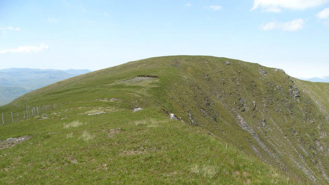 Photo could not load
V7879 : Ridge leading to Stumpa Duloigh summit
Colin Park
Hill facts and local notes
Classifications
Elevation
782m
2,566 ft
Prominence
494m
Coordinates
51.9537, -9.7654
V786793
OS Map
78
At the Summit
The summit features a well-established cairn that makes for a great photo opportunity, plus panoramic views of the surrounding mountains.
Terrain & Geology
The mountain is primarily composed of granite, giving it a rugged beauty characteristic of the area, with steep slopes and a mixture of rocky outcrops and grassy patches.
Views & Scenery
From the summit, you can see the Twelve Bens to the south, Loughs Inagh and Mask, and on a clear day, the distant peaks of the Nephin Begs.
History & Heritage
Name Origin
Stumpa Duloigh translates to 'the peak of the face/mask', possibly referring to its distinctive profile.
Historical Significance
The area is steeped in local folklore and history, with ancient stone structures nearby that hint at habitation in prehistoric times.
Getting There & Facilities
Parking
The closest parking is available at a pull-in on the N59, just south of the mountain's base. Space is limited, so arrive early.
Public Transport
Bus services run from Galway to Clifden, with regular connections. The nearest bus stop is in Recess, which is a short distance from the N59.
Nearby Facilities
Cafes and toilets are available in Recess, along with pubs that serve hearty meals post-hike.
Safety Information
Known Hazards
- Variable weather conditions can turn the trails muddy and slippery, especially after rainfall. Always check forecasts before setting off.
General Safety Tips
- Check weather conditions before setting out
- Carry appropriate clothing and equipment
- Let someone know your planned route
- Take a map, compass, and GPS device
- Carry emergency supplies: food, water, first aid kit, torch
Hills
Some common questions about the hills answered
Are there group walks up Stumpa Duloigh?
Many walkers use Walkmates to join or organise walks with others. You can check for group walks around Stumpa Duloigh through the maps
Are there other walkers around Stumpa Duloigh?
Activity varies by location and time, but Walkmates lets you see whether others have shared walks or shown interest in this area. Find other people through the walking friends search walking friends for Stumpa Duloigh search or of course create your own walk for Stumpa Duloigh
Can I organise a walk to Stumpa Duloigh?
Yes. If there aren’t any walks listed already, you can create a walk and make it available for others to join.
If you're signed up to Walkmates, you can create a walk to Stumpa Duloigh.
How do I find a walk up this hill?
There are often multiple ways to walk this hill, depending on experience and route preference. Walkmates helps you explore walks and routes that others have shared.
Can I suggest a new route up Stumpa Duloigh?
Yes. You can suggest or create routes to share with others. Walkmates focuses on the social side of walking, so routes are used to help people organise walks and explore areas together, rather than as detailed navigation tools or route libraries.
Other uses really appreciate knowledgeable walkers sharing their routes. Share your favourite route to Stumpa Duloigh here
The is an error or something incorrect about this hill. How do I let you know?
We always strive to keep the information on Walkmates as accurate as possible. If you find an error, please let us know through the contact form and we'll aim to correct it as quickly as possible
Community Discussion
Comments
Location
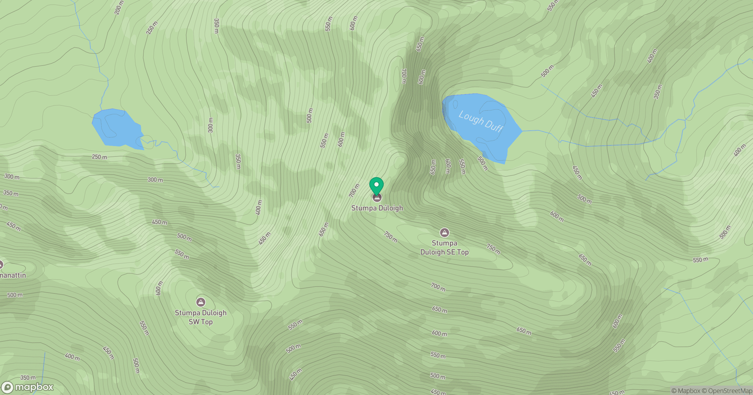
Grid reference: V786793
View on OpenStreetMapOpens a map in a new tab, centred on the hill.
No comments yet. Be the first.