
Dun Crutagain
Good walks are even better shared.
Overview
Dun Crutagain: A Highland Gem
Dun Crutagain, at 386 meters, may not be the tallest peak in the Scottish Highlands, but it has its charm in spades. Nestled in a stunning landscape, this Marilyn is a fantastic destination for hikers looking to relish beautiful vistas without having to scale the heights of Ben Nevis.
Geology
Dun Crutagain's geology consists predominantly of Granitic rock, showcasing the area's rich geological history. You’ll encounter fascinating glacial features left behind by the retreating ice sheets, making the route both a scenic and educational trek.
The Route
The most popular route begins at the B851. As you embark on this 6.5 km jaunt, expect a moderate ascent that weaves through delightful patches of heather and grassy slopes, gently leading you to the fragrant summit that awfully resembles a well-cooked steak (well, that’s how some folks see it anyway!). The hike generally takes about 2.5 hours, so don’t forget to pace yourself (and maybe pack a wee snack to enjoy at the top).
Summit Features
Upon reaching the summit, you’ll find a wee cairn that beckons tired legs to rest. The views from here are nothing short of spectacular, showcasing the undulating hills and majestic peaks that define the Scottish Highlands.
Terrain Type
The terrain primarily features grassy slopes interspersed with charming rocky outcrops, particularly as you approach the peak. Prepare yourself for some gentle slopes that might have you gasping for air (in a good way) as you take in your surroundings.
Views
On a clear day, you’re in for a real treat! The summit boasts broad vistas of the Monadhliath Mountains, with their rugged ridges and sprawling valleys. The best seasons to visit are from late spring to early autumn, especially from May to September when the Highland weather tends to play ball.
Hazards
As always in the Highlands, be vigilant of fast-changing weather conditions. It can go from bright sunshine to swirling mists quicker than you can say, “I’m off to the pub!” Good footwear is key to navigating slippery paths and those cheeky boggy spots that like to catch hikers off-guard.
Nearby Summits
If you’re keen on exploring further, nearby summits like Creag Meagaidh (1130 m) and Beinn a' Chaorainn (1036 m) offer additional trekking opportunities, rich in Highland beauty.
Access
The nearest parking is conveniently located off the B851. Create memories, not parking tickets! While public transport is a tad sparse, Newtonmore is your best bet for a local bus service, about 10 km away.
Facilities
Post-hike, nip back to Newtonmore where you’ll find cute cafes, friendly pubs, and shops sell comfortable walking socks.
History
The intriguing name 'Dun Crutagain' hints at a rich Scottish heritage. 'Dun' points to its historical status as a fortification, while 'Crutagain' may reference epic tales of local figures.
So whether you’re a seasoned hiker or a leisurely amble enthusiast, Dun Crutagain invites you to bask in its beauty, indulge in the Highland charm, and perhaps enjoy a cheeky biscuit at the summit!
Enjoy your adventure!
Explore routes near Dun Crutagain
Public walks starting within 80 km of this hill. Nearby does not mean a route reaches the summit; check its map and access before setting out.
Crinan Canal: Bellanoch and Dunardry towpath return
View route
Glen Kin group walk
View route
Beinn Ime from Succoth
View route
The Cobbler from Succoth Carpark
View route
Route planning notes
These notes describe possible approaches, not verified navigable routes or permission to cross land. Check current paths, local access rules and conditions before setting out.
B851 Starting Point
A well-marked path from the B851 road offers a gentle ascent through heather and grassy slopes, leading you to the summit with minimal fuss.
Make a day of it, together
Find someone to share the walk with, or organise a day out along a route you like.
Hill facts and local notes
Classifications
Elevation
274m
899 ft
Prominence
109m
Coordinates
56.2643, -5.5770
NM785137
OS Map
55
Explorer: 359
At the Summit
The summit features a modest cairn that provides a perfect spot for a well-deserved snack. On a clear day, it’s a fantastic place to catch your breath and have a natter about the incredible views.
Terrain & Geology
Dun Crutagain is predominantly composed of Granitic rock, offering a unique insight into the geological history of the Highlands. The summit area displays extensive glacial features, a testament to the shaping forces of the last Ice Age.
Views & Scenery
Panoramic views of the surrounding hills, including distant peaks of the Monadhliath Mountains, as well as sweeping vistas over the sprawling landscapes of the Highlands.
History & Heritage
Name Origin
The name 'Dun Crutagain' is derived from Scottish Gaelic, where 'Dun' signifies a fort or hill, and 'Crutagain' possibly refers to a historical or local figure.
Historical Significance
This mountain carries local folklore and traditions, often tied to the surrounding clans and their historical battles for territory.
Getting There & Facilities
Check current local access restrictions, parking rules and transport timetables before travelling. These notes do not confirm public access to the summit.
Parking
There's a small car park off the B851, with enough space for several vehicles; be sure to park responsibly.
Public Transport
Currently, public transport options are limited. The nearest regular bus service runs to the village of Newtonmore, which is approximately 10 km away.
Nearby Facilities
In Newtonmore, you’ll find a selection of cafes, pubs, and shops, as well as public toilets, making it a great place to prepare for your hike or grab a bite afterwards.
Safety Information
Known Hazards
- Watch out for sudden weather changes common in the Highlands; ensure you're prepared for all conditions. Slippery paths and occasional boggy areas can be challenging, so good footwear is essential.
General Safety Tips
- Check weather conditions before setting out
- Carry appropriate clothing and equipment
- Let someone know your planned route
- Take a map, compass, and GPS device
- Carry emergency supplies: food, water, first aid kit, torch
Hills
Some common questions about the hills answered
Are there group walks up Dun Crutagain?
Many walkers use Walkmates to join or organise walks with others. You can check for group walks around Dun Crutagain through the maps
Are there other walkers around Dun Crutagain?
Activity varies by location and time, but Walkmates lets you see whether others have shared walks or shown interest in this area. Find other people through the walking friends search walking friends for Dun Crutagain search or of course create your own walk for Dun Crutagain
Can I organise a walk to Dun Crutagain?
Yes. If there aren’t any walks listed already, you can create a walk and make it available for others to join.
If you're signed up to Walkmates, you can create a walk to Dun Crutagain.
How do I find a walk up this hill?
There are often multiple ways to walk this hill, depending on experience and route preference. Walkmates helps you explore walks and routes that others have shared.
Can I suggest a new route up Dun Crutagain?
Yes. You can suggest or create routes to share with others. Walkmates focuses on the social side of walking, so routes are used to help people organise walks and explore areas together, rather than as detailed navigation tools or route libraries.
Other uses really appreciate knowledgeable walkers sharing their routes. Share your favourite route to Dun Crutagain here
The is an error or something incorrect about this hill. How do I let you know?
We always strive to keep the information on Walkmates as accurate as possible. If you find an error, please let us know through the contact form and we'll aim to correct it as quickly as possible
Community Discussion
Comments
Location
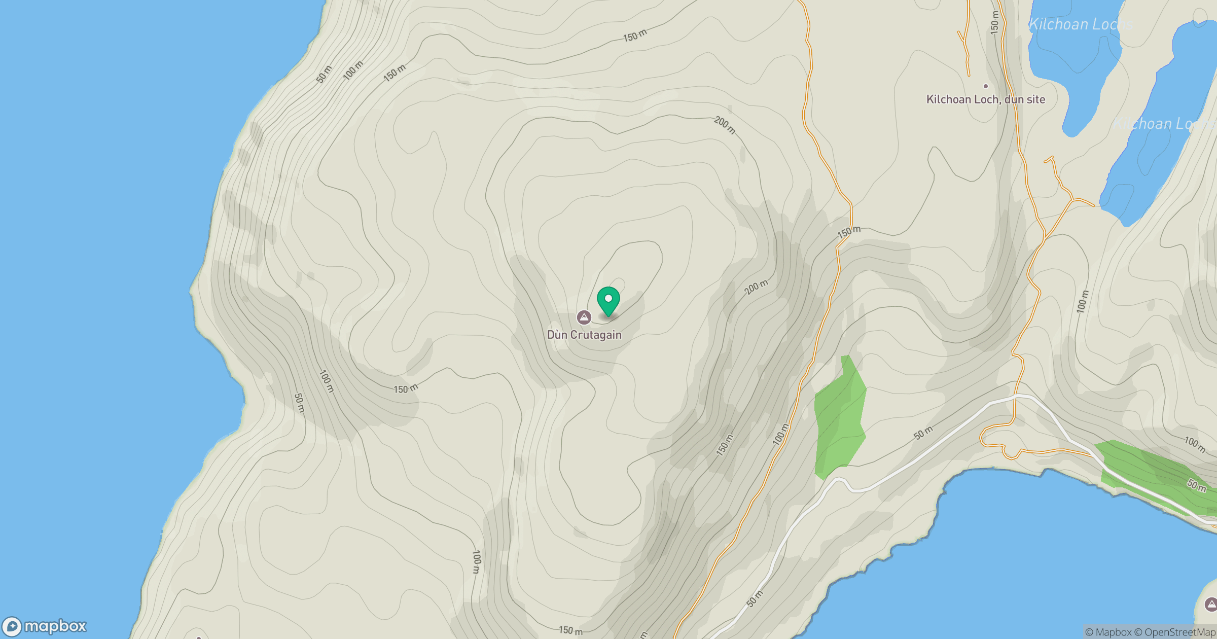
Grid reference: NM785137
View on OpenStreetMapOpens a map in a new tab, centred on the hill.
Hills within 30 km
Straight-line distance, not a walking route or confirmation of access.
No comments yet. Be the first.