
Dromona Hill
Good walks are even better shared.
Overview
Dromona Hill
Overview
Dromona Hill, a delightful Hewitt peak rising to 276 meters, is located in the enchanting Northern Ireland. Nestled among the scenic landscapes of Rostrevor, it is a treasure for hikers looking to immerse themselves in nature.
Getting There
Access: The nearest town, Rostrevor, is charming and provides essential amenities.
Parking: Kilbroney Park offers ample parking with facilities to make your start more pleasant. Whether you're lugging a hefty backpack or a packed lunch, you won't have to worry about where to stash your wheels.
Routes
Dromona Hill Circuit
Beginning at Rostrevor, this moderate circuit is approximately 8.5 km long and takes around 3.5 hours to complete. The beautifully maintained paths will have you feeling like you’re walking in a postcard.
Short Ascent from Kilbroney Park
For the ambitious or those short on time, this challenging 2.5 km route takes approximately 1.5 hours. It’s steeper, but oh, the payoff in views!
Summit Features
At the summit, a small but mighty cairn awaits to congratulate your efforts. While it won't exactly speak, it does serve as a reassurance that you’ve made it to the top!
Terrain
Expect a mix of grassy paths and rocky outcrops. The terrain can vary depending on your chosen route, but the experience will be worth every step.
Views
On a clear day, not much can beat the views from Dromona Hill. Gaze towards Carlingford Lough, and you might even see the Mourne Mountains watching over you like sentinels.
Best Seasons
Spring and early summer are fantastic for views, with stunning wildflowers enhancing your panoramic experience. For the early risers, dawn creates a fantastic mystical atmosphere over the landscape.
Hazards
Watch your footing on loose stones and be mindful of steep drops on your ascent. It’s all fun and games until someone loses their footing, right? Also, be aware of changing weather; it can turn quicker than a cat on a hot tin roof.
Nearby Summits
Within arm's reach of Dromona Hill, you have the towering Slieve Donard and Binnian. If you feel adventurous, why not include them in your hiking plan?
History
The name Dromona means 'ridge of the river,' fitting perfectly with the serene, rolling landscape. Historically, this area holds significance due to nearby archaeological sites, captivating any history buff.
Enjoy your hike up Dromona Hill; keep your camera ready, and don’t forget to soak in the sights!
Explore routes near Dromona Hill
Public walks starting within 80 km of this hill. Nearby does not mean a route reaches the summit; check its map and access before setting out.
No public routes are currently listed within 80 km of Dromona Hill on Walkmates. This does not mean there are no paths here. Explore the map and check local access information before planning a walk.
Route planning notes
These notes describe possible approaches, not verified navigable routes or permission to cross land. Check current paths, local access rules and conditions before setting out.
Dromona Hill Circuit
A scenic loop starting from the village of Rostrevor, taking you along well-marked paths with occasional challenging stretches.
Short Ascent from Kilbroney Park
A shorter but steeper route straight up from Kilbroney Park, perfect for those short on time but high on ambition.
Make a day of it, together
Find someone to share the walk with, or organise a day out along a route you like.
Hill facts and local notes
Classifications
Elevation
156m
512 ft
Prominence
102m
Coordinates
52.0974, -7.8402
X110939
OS Map
81
At the Summit
The summit of Dromona Hill boasts a small cairn, which may inspire a sense of accomplishment — or at least a good photo op!
Terrain & Geology
Dromona Hill features primarily sandstone and limestone, offering a glimpse into the geological history of the region. The rock formations here are relatively young geologically speaking, dating back to the Carboniferous period.
Views & Scenery
From the summit, enjoy breathtaking views of Carlingford Lough and the Mourne Mountains—truly a feast for the eyes.
History & Heritage
Name Origin
Dromona is derived from the old Irish 'Droim Anna' meaning 'ridge of the river' – quite fitting given its location.
Historical Significance
The area provides historical insights into early settlements, with nearby archaeological sites revealing traces of ancient inhabitants.
Getting There & Facilities
Check current local access restrictions, parking rules and transport timetables before travelling. These notes do not confirm public access to the summit.
Parking
Kilbroney Park has a large car park with facilities, perfect for those looking to begin their hike refreshed.
Public Transport
Buses run regularly from Newry to Rostrevor, making public transport a feasible option for hikers.
Nearby Facilities
Rostrevor offers several cafes and a pub where you can grab a hot drink or a bite to eat post-hike. Toilets are available at Kilbroney Park.
Safety Information
Known Hazards
- Loose stones and steep drops in certain sections, so mind your footing; also, be wary of sudden weather changes typical in the area.
General Safety Tips
- Check weather conditions before setting out
- Carry appropriate clothing and equipment
- Let someone know your planned route
- Take a map, compass, and GPS device
- Carry emergency supplies: food, water, first aid kit, torch
Hills
Some common questions about the hills answered
Are there group walks up Dromona Hill?
Many walkers use Walkmates to join or organise walks with others. You can check for group walks around Dromona Hill through the maps
Are there other walkers around Dromona Hill?
Activity varies by location and time, but Walkmates lets you see whether others have shared walks or shown interest in this area. Find other people through the walking friends search walking friends for Dromona Hill search or of course create your own walk for Dromona Hill
Can I organise a walk to Dromona Hill?
Yes. If there aren’t any walks listed already, you can create a walk and make it available for others to join.
If you're signed up to Walkmates, you can create a walk to Dromona Hill.
How do I find a walk up this hill?
There are often multiple ways to walk this hill, depending on experience and route preference. Walkmates helps you explore walks and routes that others have shared.
Can I suggest a new route up Dromona Hill?
Yes. You can suggest or create routes to share with others. Walkmates focuses on the social side of walking, so routes are used to help people organise walks and explore areas together, rather than as detailed navigation tools or route libraries.
Other uses really appreciate knowledgeable walkers sharing their routes. Share your favourite route to Dromona Hill here
The is an error or something incorrect about this hill. How do I let you know?
We always strive to keep the information on Walkmates as accurate as possible. If you find an error, please let us know through the contact form and we'll aim to correct it as quickly as possible
Community Discussion
Comments
Location
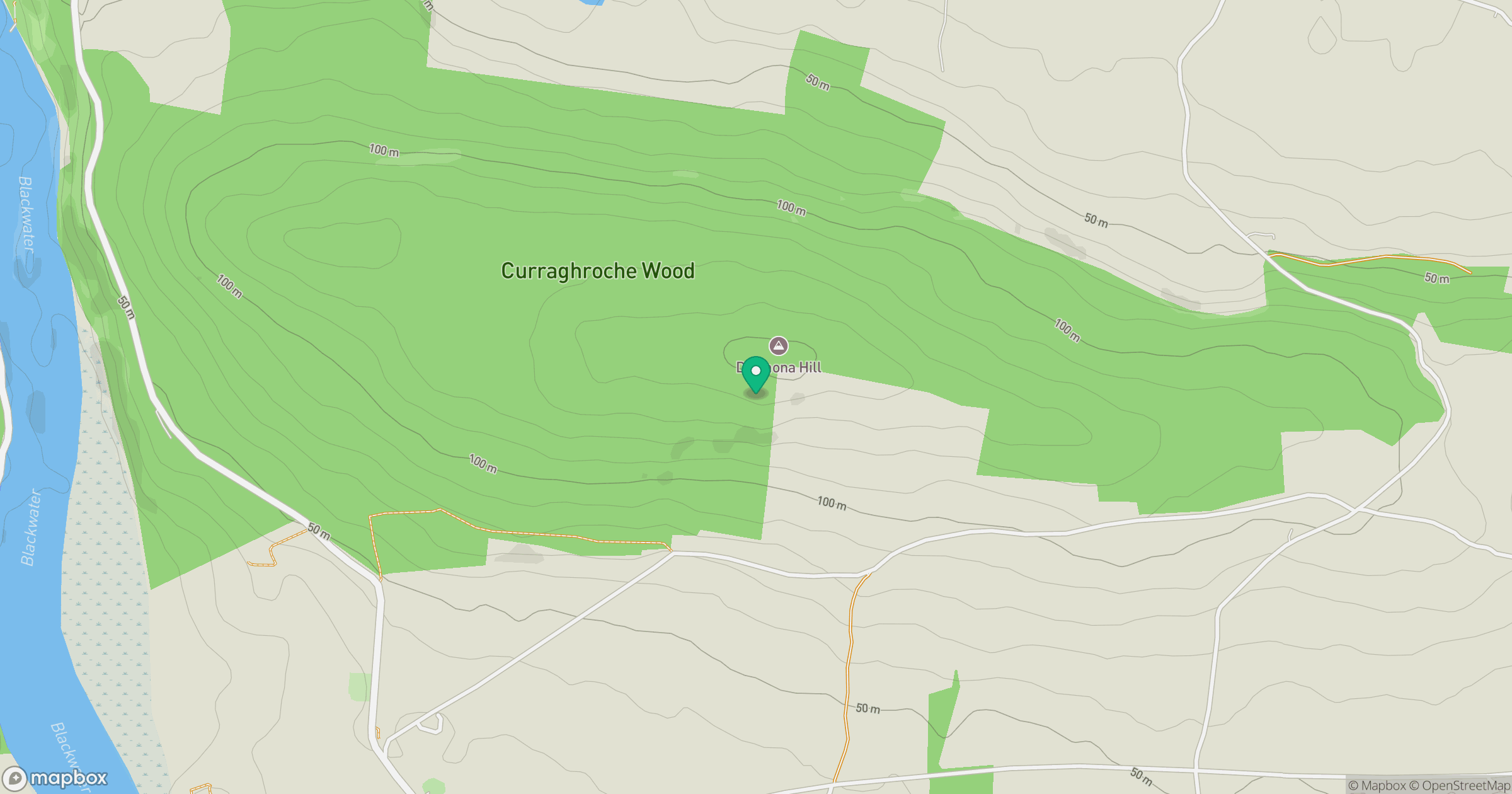
Grid reference: X110939
View on OpenStreetMapOpens a map in a new tab, centred on the hill.
Hills within 30 km
Straight-line distance, not a walking route or confirmation of access.
Carronadavderg [Carn an Daimh Dheirg]
301m
Knocknanask
486m
Knockmealdown [Cnoc Mhaoldomhnaigh]
792m
Sugarloaf Hill
663m
Knockshanahullion
653m
No comments yet. Be the first.