
Knockakeo
Good walks are even better shared.
Overview
Knockakeo: The Gentle Giant of the Antrim Hills
Nestled in the beautiful Antrim Hills, Knockakeo stands at 211 meters, making it a modest but delightful Marilyn that offers panoramic views without the arduous climb. Whether you are contemplating a leisurely hike, or just looking for an excuse to escape the hustle and bustle, this hill is a perfect choice.
Geology
Knockakeo's geology is primarily sedimentary, comprised of sandstone and shale. These sturdy materials may not seem unique at first glance, but they contribute to a landscape that is both stunning and rugged—offering just enough challenge to make hikers feel like they've earned their afternoon cuppa!
Routes
The Knockakeo Circular Route is a wonderful way to explore the area. Starting from the small layby, you’ll wind through heather-clad paths, making it a moderate trek at 5 km—ideal for those looking to stretch their legs without breaking a sweat. Expect to spend around 2.5 hours on the trail, which is perfect for a lazy afternoon.
Summit Features
The summit is home to a quaint stone cairn, but the real feature is the magnificent view it affords. Grab your camera, and remember—it's not a hill until you've snapped a picture atop it!
Terrain
The terrain can be best described as grassy with occasional rocky outcrops. Be prepared for some boggy sections that might feel more like an obstacle course in places. Worth remembering: wellington boots may just become your best friend while tackling these parts!
Views
One of the highlights from the top includes breathtaking sightings of the Mourne Mountains and the tranquillity of the far-off North Coast. For the best views, aim for late spring through early autumn when the fields are in full bloom—not to mention the good weather guarantees you won’t come down looking like a drowned rat!
Hazards
Hikers should be aware that the terrain can be slippery, particularly in wet conditions. Be careful of the bogs—they are sneaky! It's also best to heed any weather warnings, as the mist can roll in faster than you can say 'pint of Guinness'.
Access
Access to Knockakeo is relatively straightforward. The nearest parking is a small layby that can accommodate a few cars. If you're relying on public transport, bus services operate to Cullybackey, followed by a short taxi ride to the hill's base. As for facilities, you won't find any on-site, but the friendly village of Cullybackey has shops aplenty for any snacks you may need.
History
The name 'Knockakeo' harks back to ancient times, translating from Irish as 'hill of the willow'. This area has a rich tapestry of folklore, with tales of ancient gatherings and mystical activities that add charm to every footstep taken on the hill.
So lace up those hiking boots and embark on a journey to Knockakeo—a summit that promises adventure with a sprinkle of magic from the past.
Last Updated: 2023-10-10
Source: Ordnance Survey
Explore routes near Knockakeo
Public walks starting within 80 km of this hill. Nearby does not mean a route reaches the summit; check its map and access before setting out.
No public routes are currently listed within 80 km of Knockakeo on Walkmates. This does not mean there are no paths here. Explore the map and check local access information before planning a walk.
Route planning notes
These notes describe possible approaches, not verified navigable routes or permission to cross land. Check current paths, local access rules and conditions before setting out.
Knockakeo Circular Route
A scenic loop starting from the car park that winds through heather-covered hills and offers splendid views.
Make a day of it, together
Find someone to share the walk with, or organise a day out along a route you like.
Hill facts and local notes
Classifications
Elevation
238m
781 ft
Prominence
112m
Coordinates
52.0175, -8.0823
W944850
OS Map
81
At the Summit
The summit has a small stone cairn and a remarkable viewpoint that can sweep your breath away—just don't forget to bring it back!
Terrain & Geology
Predominantly composed of sedimentary rock, with sandstone and shale layers that give it both stability and a few interesting crags for the curious rock climber.
Views & Scenery
From the summit, you can see the sprawling patchwork of fields below, the distant Mourne Mountains, and on a clear day, the stunning North Coast.
History & Heritage
Name Origin
The name 'Knockakeo' derives from the Irish 'Cnoc a Chao', which translates to 'hill of the willow'.
Historical Significance
Prominent in local folklore, the hill is said to be a gathering spot for ancient peoples.
Getting There & Facilities
Check current local access restrictions, parking rules and transport timetables before travelling. These notes do not confirm public access to the summit.
Parking
There's a small layby off the main road (B14) about 1 km from the trailhead, suitable for 3-4 cars.
Public Transport
Bus services operate from Ballymena to the nearby village of Cullybackey, roughly a 10-minute taxi ride to the starting point.
Nearby Facilities
No facilities on-site, but Cullybackey has local shops and a few teahouses for post-hike sustenance.
Safety Information
Known Hazards
- Boggy ground can be deceptive, so watch your step! Additionally, mist can roll in quickly, reducing visibility.
General Safety Tips
- Check weather conditions before setting out
- Carry appropriate clothing and equipment
- Let someone know your planned route
- Take a map, compass, and GPS device
- Carry emergency supplies: food, water, first aid kit, torch
Hills
Some common questions about the hills answered
Are there group walks up Knockakeo?
Many walkers use Walkmates to join or organise walks with others. You can check for group walks around Knockakeo through the maps
Are there other walkers around Knockakeo?
Activity varies by location and time, but Walkmates lets you see whether others have shared walks or shown interest in this area. Find other people through the walking friends search walking friends for Knockakeo search or of course create your own walk for Knockakeo
Can I organise a walk to Knockakeo?
Yes. If there aren’t any walks listed already, you can create a walk and make it available for others to join.
If you're signed up to Walkmates, you can create a walk to Knockakeo.
How do I find a walk up this hill?
There are often multiple ways to walk this hill, depending on experience and route preference. Walkmates helps you explore walks and routes that others have shared.
Can I suggest a new route up Knockakeo?
Yes. You can suggest or create routes to share with others. Walkmates focuses on the social side of walking, so routes are used to help people organise walks and explore areas together, rather than as detailed navigation tools or route libraries.
Other uses really appreciate knowledgeable walkers sharing their routes. Share your favourite route to Knockakeo here
The is an error or something incorrect about this hill. How do I let you know?
We always strive to keep the information on Walkmates as accurate as possible. If you find an error, please let us know through the contact form and we'll aim to correct it as quickly as possible
Community Discussion
Comments
Location
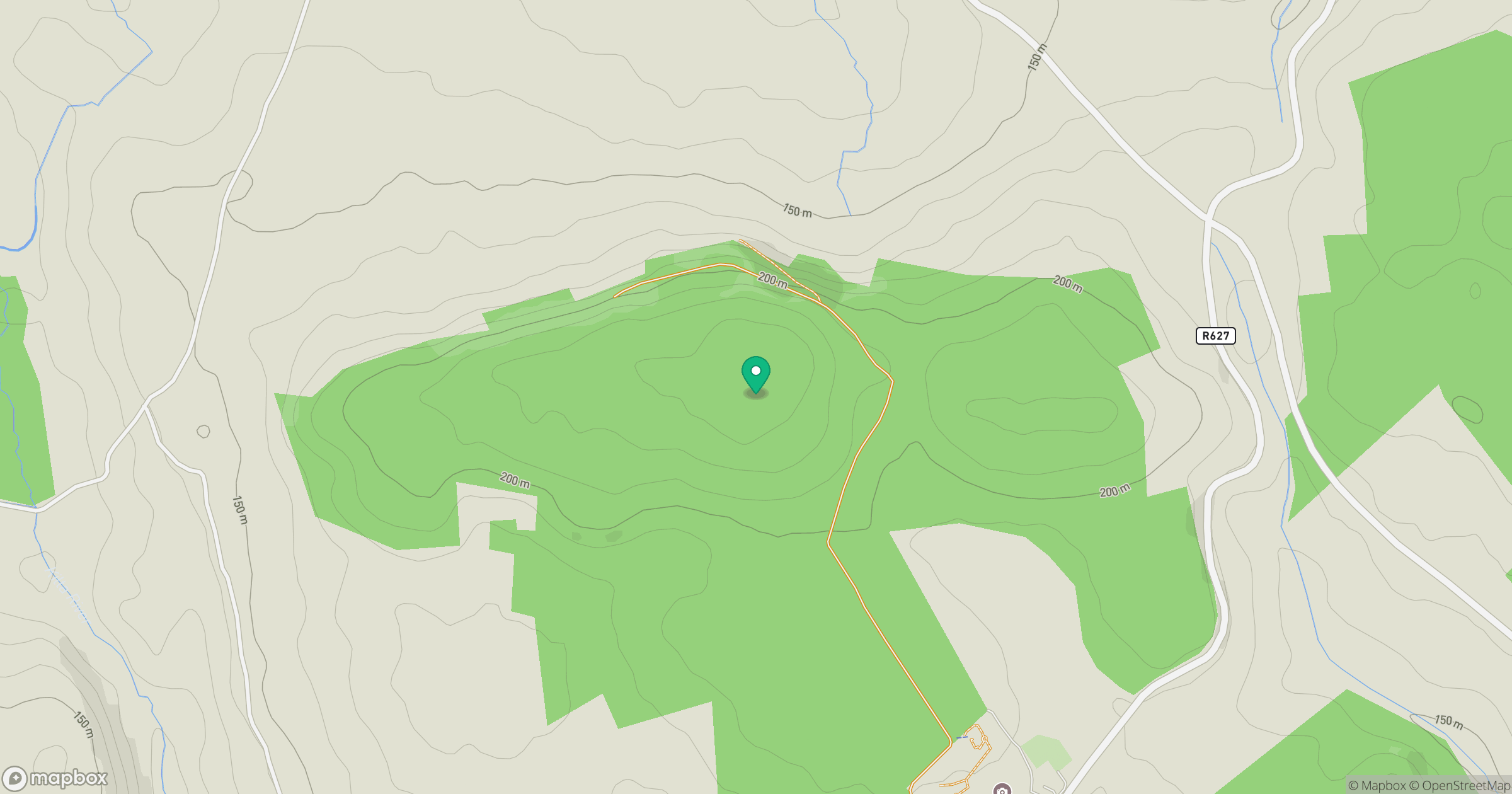
Grid reference: W944850
View on OpenStreetMapOpens a map in a new tab, centred on the hill.
Hills within 30 km
Straight-line distance, not a walking route or confirmation of access.
Knockadullaun
352m
Knockshanahullion
653m
Sugarloaf Hill
663m
Knockmealdown [Cnoc Mhaoldomhnaigh]
792m
Knocknanask
486m
No comments yet. Be the first.