

Capler Camp
Good walks are even better shared.
SO5932 : Capler Wood
Richard Webb Photo source
Overview
Capler Camp
Capler Camp is a fascinating hill located in Herefordshire, known for its historical significance and stunning views. Rising to an elevation of 400 meters, the site is not only a haven for walkers but also a treasure trove of history and geology.
Geology
The geological composition of Capler Camp primarily consists of Silurian limestone and mudstone. As you traverse the area, keep an eye out for the distinct stratification of the rocks, which tells a story of ancient marine environments. The rugged terrain provides a great opportunity for geology enthusiasts to observe various rock formations.
Routes
One of the most popular routes is the Capler Camp Circular Walk. At 5 km in length, this route takes roughly 2 hours to complete and is rated as moderate. Along the way, you can appreciate the serene beauty of the surrounding woodlands and lush meadows.
Summit Features
Upon reaching the summit, hikers are greeted by remnants of an Iron Age hill fort. The ramparts may not shield you from the wind, but they do offer stunning panoramic views! If you happen to stumble upon what looks like an ancient altar, it’s merely a pile of stones—so you can save your offerings for another day!
Views
The vistas from the top of Capler Camp are nothing short of breathtaking. You can see the winding River Wye, the lush hills of Herefordshire, and even the Malvern Hills on a clear day. The best times to experience these views are in late spring through early autumn, when the wildflowers are in full bloom and the skies are vibrant.
Hazards
While Capler Camp is generally safe for hikers, beware of slippery slopes after rain. The terrain can be uneven, so a good pair of sturdy shoes is recommended. As always, keep your wits about you!
Access
Getting to Capler Camp is relatively straightforward. There is a small parking area along the lane, but it fills up fast, so it's wise to arrive early. Public transport to the nearby village of Fownhope is available, making the hill accessible for those without a vehicle.
Facilities
While Capler Camp itself lacks facilities, the nearby village offers a charming café and public toilets, perfect for a cuppa before or after your adventure.
History
The name 'Capler' originates from Old English, meaning 'enclosure' or 'fortified'. This alludes to its historical relevance as a hill fort. The site not only served a defensive purpose but also offered strategic views over the Wye Valley during the Iron Age.
Whether you’re a history buff, a geology enthusiast, or simply in search of a good walk, Capler Camp has something to offer everyone. Just remember to pack your sense of adventure—and maybe a sandwich or two!
Explore routes near Capler Camp
Walks starting near this hill. Open a route to check its map, distance and full itinerary.
Hereford Walk with Men Walking & Talking
View route
Forest of Dean Hicksters Way Woodland Circuit from Cannop
View route
Forest of Dean Full Colliers Trail from Cannop Ponds
View route
Malvern Hills Circular Walk
View route
Route planning notes
These notes describe possible approaches. Check a route's map and access information when planning your walk.
Capler Camp Circular Walk
A delightful circular route that takes you around the hill and back, offering glimpses of the lush countryside and the surrounding woodlands.
Make a day of it, together
Find someone to share the walk with, or organise a day out along a route you like.
Photo Gallery
View all Photo could not load
SO5932 : Capler Wood
Richard Webb
 Photo could not load
SO5932 : Capler Camp, Inspection Chamber
thejackrustles
 Photo could not load
SO5932 : Russian dock, fruits
Pauline E
 Photo could not load
SO5932 : In Capler Wood
Pauline E
 Photo could not load
SO5932 : Choice of paths, Capler Wood
Pauline E
 Photo could not load
SO5932 : Waymarked footpath on Capler Camp
Jeremy Bolwell
 Photo could not load
SO5932 : Field, Capler Camp
Richard Webb
 Photo could not load
SO5932 : Ramparts, Capler Camp
Richard Webb
 Photo could not load
SO5932 : Ramparts, Capler Camp
Richard Webb
Hill facts and local notes
Classifications
Elevation
182m
597 ft
Prominence
79m
Coordinates
51.9937, -2.5969
SO591329
OS Map
149
Explorer: 189
At the Summit
The summit features an impressive Iron Age hill fort rampart with stunning views. There's a historic stone structure that hikers occasionally mistake for an ancient altar—though we assure you, it's just a pile of rocks!
Terrain & Geology
Capler Camp is predominantly composed of the Silurian limestone and mudstone, providing a rocky yet stable terrain. The stratification of these rocks presents a fascinating insight into the geological past of the region, with some areas serving as excellent examples of ancient marine deposits.
Views & Scenery
From the summit, you'll catch sight of the picturesque River Wye, the rolling hills of the Herefordshire countryside, and on a clear day, the Malvern Hills.
History & Heritage
Name Origin
The name 'Capler' is believed to be derived from the Old English 'cape', meaning 'enclosure' or 'fortified', indicative of its historical significance as a hill fort.
Historical Significance
Capler Camp was an important fortification during the Iron Age, serving as a strategic lookout point over the Wye Valley.
Getting There & Facilities
Parking
There is a small parking area along the lane leading to Capler Camp, suitable for a few vehicles. Arrive early to secure a space!
Public Transport
Regular bus services run from Hereford to the nearby village of Fownhope, from where a short walk leads to Capler Camp.
Nearby Facilities
There are no facilities on the hill itself, but the village of Fownhope offers a quaint café and public toilets.
Safety Information
Known Hazards
- Potentially slippery slopes after rainfall and uneven surfaces can be deceitful. Keep your wits about you!
General Safety Tips
- Check weather conditions before setting out
- Carry appropriate clothing and equipment
- Let someone know your planned route
- Take a map, compass, and GPS device
- Carry emergency supplies: food, water, first aid kit, torch
Hills
Some common questions about the hills answered
Are there group walks up Capler Camp?
Many walkers use Walkmates to join or organise walks with others. You can check for group walks around Capler Camp through the maps
Are there other walkers around Capler Camp?
Activity varies by location and time, but Walkmates lets you see whether others have shared walks or shown interest in this area. Find other people through the walking friends search walking friends for Capler Camp search or of course create your own walk for Capler Camp
Can I organise a walk to Capler Camp?
Yes. If there aren’t any walks listed already, you can create a walk and make it available for others to join.
If you're signed up to Walkmates, you can create a walk to Capler Camp.
How do I find a walk up this hill?
There are often multiple ways to walk this hill, depending on experience and route preference. Walkmates helps you explore walks and routes that others have shared.
Can I suggest a new route up Capler Camp?
Yes. You can suggest or create routes to share with others. Walkmates focuses on the social side of walking, so routes are used to help people organise walks and explore areas together, rather than as detailed navigation tools or route libraries.
Other uses really appreciate knowledgeable walkers sharing their routes. Share your favourite route to Capler Camp here
The is an error or something incorrect about this hill. How do I let you know?
We always strive to keep the information on Walkmates as accurate as possible. If you find an error, please let us know through the contact form and we'll aim to correct it as quickly as possible
Community Discussion
Comments
Location
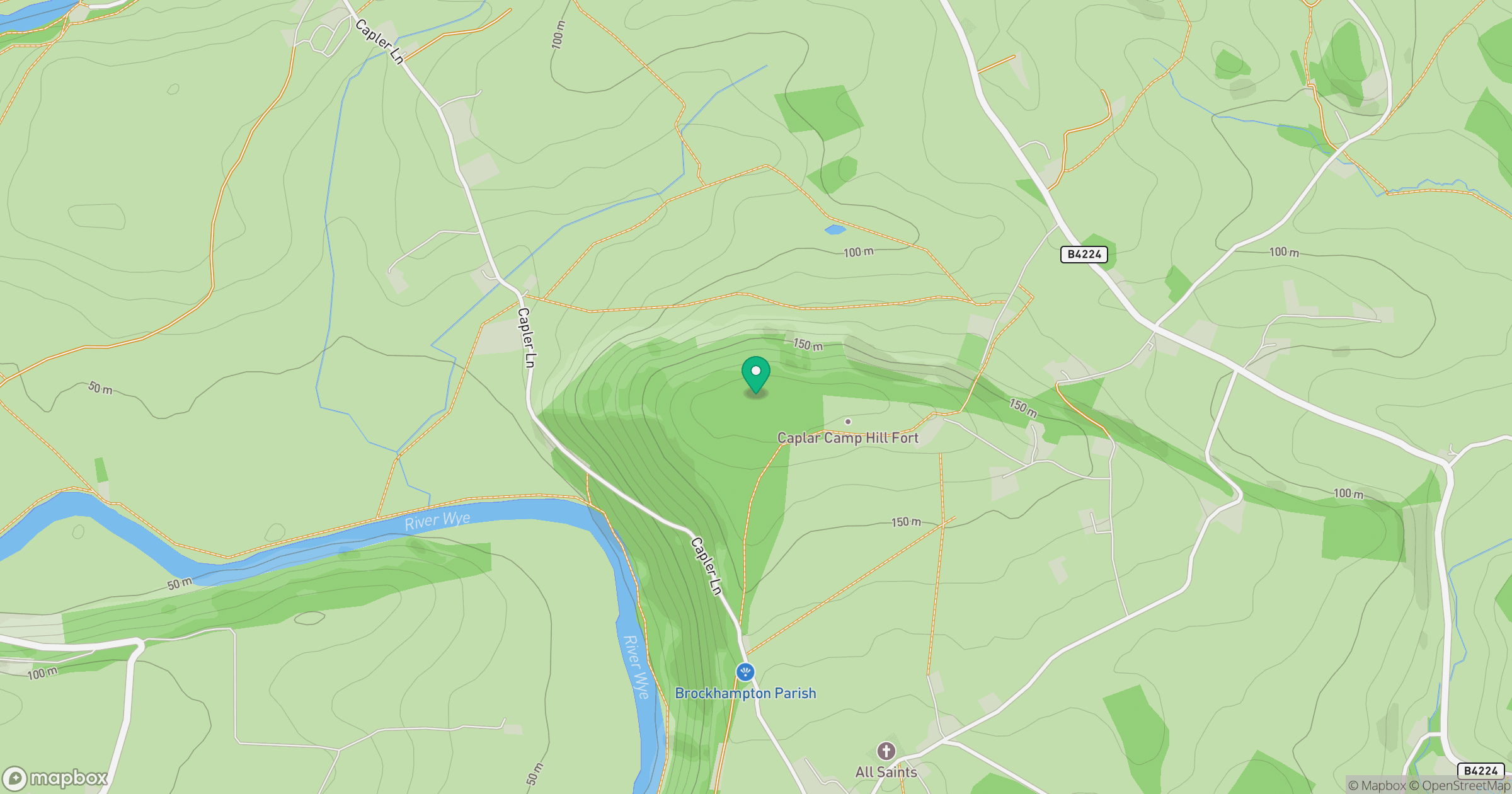
Grid reference: SO591329
View on OpenStreetMapOpens a map in a new tab, centred on the hill.
Nearby Hills
Worcestershire Beacon
425m
Titterstone Clee Hill
533m
Long Mynd - Pole Bank
517m
The Wrekin
407m
Stiperstones
537m
No comments yet. Be the first.