

Brimmond Hill
Good walks are even better shared.
Overview
Brimmond Hill: A Great Escape
Brimmond Hill, standing at a modest 220 meters, is nestled in the picturesque Aberdeenshire landscape. Although it may not rival the towering peaks of the Scottish Highlands, its charm lies in the accessible beauty it offers local hikers and outdoor enthusiasts.
Geology and Wildlife
This hill is primarily composed of granite, with its rugged rock faces revealing a fascinating geological history. As you climb, keep an eye out for local wildlife, including rabbits, various bird species, and perhaps a curious red squirrel!
The Route
The Brimmond Hill Circular Walk is the most popular route, spanning approximately 5 km. This moderate trail offers a decent workout without leaving you gasping for air. As you follow the well-marked paths, take time to appreciate the stunning views opening up around you.
Summit Features
Upon reaching the summit, you'll be welcomed by a prominent trig point and a hefty stone cairn that beg to be photographed. It's not just for show, mind you; these features have been guiding hikers for years.
Terrain and Conditions
While the terrain is relatively manageable, some sections can be a tad slippery, especially after rain. So, if you're planning a hike after a downpour, be sure to wear appropriate footwear — no one wants to go home with muddy socks!
The View from the Top
From the summit of Brimmond Hill, the views are simply marvellous! On a clear day, gaze towards the horizon to catch spectacular sights of Aberdeen and the North Sea. Not to mention the dramatic landscape of Bennachie in the background. The best times to enjoy these vistas are during spring or autumn, when the foliage is at its most vibrant.
Nearby Attractions
If you fancy a longer adventure, nearby summits, such as Mither Tap on Bennachie, beckon with their imposing heights and challenging trails.
Access and Facilities
Getting to Brimmond Hill is straightforward. There's ample parking at the designated car park, and for those relying on public transport, buses from Aberdeen city centre can drop you nearby. The village of Kingswells offers a lovely café for a post-hike treat along with public toilets.
A Touch of History
There's a fascinating history associated with Brimmond Hill, with its name believed to be rooted in local geological features. This landmark has served as a guidepost and a scenic getaway for countless hikers through the centuries.
In conclusion, whether you're a seasoned hiker or just out for a delightful stroll, Brimmond Hill is a gem not to be overlooked. So grab your walking boots, and off you go!
Final Thoughts
Remember, always leave no trace and take in the beauty of the great outdoors! Happy hiking!
Explore routes near Brimmond Hill
Public walks starting within 80 km of this hill. Nearby does not mean a route reaches the summit; check its map and access before setting out.
Walk Aberdeen – Kingswells easy social walk
View route
Formartine and Buchan Way: Dyce to Udny Station
View route
Deeside Way
View route
Milton of Crathes to Drumoak: Deeside Way return
View route
Route planning notes
These notes describe possible approaches, not verified navigable routes or permission to cross land. Check current paths, local access rules and conditions before setting out.
Brimmond Hill Circular Walk
A well-marked circular route that takes you up to the summit and back along scenic paths. Ideal for a quick outdoor escape.
Make a day of it, together
Find someone to share the walk with, or organise a day out along a route you like.
Photo Gallery
View all Photo could not load
NJ8509 : Sign and seat on Brimmond Hill
Richard Webb
 Photo could not load
NJ8509 : Brimmond Hill Country Park
Andrew
 Photo could not load
NJ8509 : Aberdeen Winter Sunrise
Andrew
 Photo could not load
NJ8509 : Trig point on Brimmond Hill
Trevor Littlewood
 Photo could not load
NJ8509 : OS Triangulation Pillar on Brimmond Hill, Aberdeen
Andrew Tryon
 Photo could not load
NJ8509 : Top of Brimmond Hill
Bill Harrison
 Photo could not load
NJ8509 : Transmitter Mast on Brimmond Hill
David Robinson
 Photo could not load
NJ8509 : Trig point and cairn on Brimmond Hill
Steven Brown
 Photo could not load
NJ8509 : Brimmond Hill Country Park
Andrew

NJ8509 : Brimmond Hill Trig Pillar
Scott Cormie
Hill facts and local notes
Classifications
Elevation
266m
873 ft
Prominence
159m
Coordinates
57.1730, -2.2396
NJ856091
OS Map
38
Explorer: 406E
At the Summit
The summit features a prominent trig point and a large stone cairn, making it a popular spot for panoramic photographs (and potential selfies).
Terrain & Geology
Composed predominantly of granite, Brimmond Hill is a great example of the geological beauty of northeast Scotland. Its rocky outcrops and smooth slopes offer insights into the region's glacial history.
Views & Scenery
On a clear day, you can see across the city of Aberdeen, the North Sea, and the surrounding countryside including Bennachie to the west.
History & Heritage
Name Origin
The name 'Brimmond' is believed to derive from 'Brim' meaning 'brimstone' due to the area's reddish granite.
Historical Significance
The hill has been a landmark for centuries, serving as a vital point of reference in the region's navigation.
Getting There & Facilities
Check current local access restrictions, parking rules and transport timetables before travelling. These notes do not confirm public access to the summit.
Parking
Parking available at the Brimmond Hill car park, near the starting point for the trails.
Public Transport
Buses from Aberdeen city centre, with a short walk from the nearest bus stop to the car park.
Nearby Facilities
A lovely café in the nearby village of Kingswells offers refreshments, as well as public toilets.
Safety Information
Known Hazards
- Steep sections can become muddy after rain; watch your step! Also, visibility can drop quickly in foggy conditions.
General Safety Tips
- Check weather conditions before setting out
- Carry appropriate clothing and equipment
- Let someone know your planned route
- Take a map, compass, and GPS device
- Carry emergency supplies: food, water, first aid kit, torch
Hills
Some common questions about the hills answered
Are there group walks up Brimmond Hill?
Many walkers use Walkmates to join or organise walks with others. You can check for group walks around Brimmond Hill through the maps
Are there other walkers around Brimmond Hill?
Activity varies by location and time, but Walkmates lets you see whether others have shared walks or shown interest in this area. Find other people through the walking friends search walking friends for Brimmond Hill search or of course create your own walk for Brimmond Hill
Can I organise a walk to Brimmond Hill?
Yes. If there aren’t any walks listed already, you can create a walk and make it available for others to join.
If you're signed up to Walkmates, you can create a walk to Brimmond Hill.
How do I find a walk up this hill?
There are often multiple ways to walk this hill, depending on experience and route preference. Walkmates helps you explore walks and routes that others have shared.
Can I suggest a new route up Brimmond Hill?
Yes. You can suggest or create routes to share with others. Walkmates focuses on the social side of walking, so routes are used to help people organise walks and explore areas together, rather than as detailed navigation tools or route libraries.
Other uses really appreciate knowledgeable walkers sharing their routes. Share your favourite route to Brimmond Hill here
The is an error or something incorrect about this hill. How do I let you know?
We always strive to keep the information on Walkmates as accurate as possible. If you find an error, please let us know through the contact form and we'll aim to correct it as quickly as possible
Community Discussion
Comments
Location
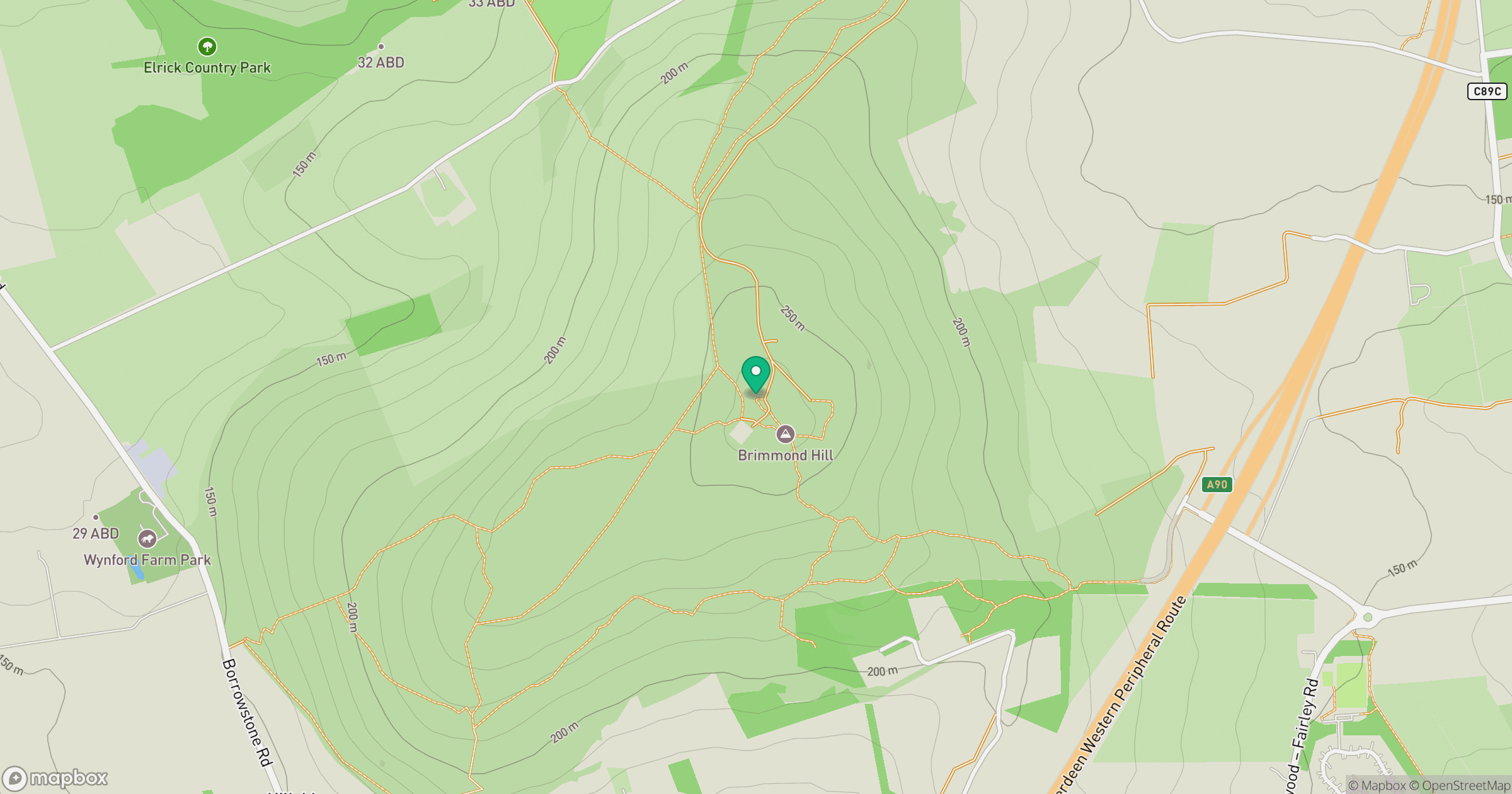
Grid reference: NJ856091
View on OpenStreetMapOpens a map in a new tab, centred on the hill.
Hills within 30 km
Straight-line distance, not a walking route or confirmation of access.
Bennachie - Oxen Craig
529m
Tyrebagger Hill
250m
Lawel Hill
236m
Cairn-mon-earn
378m
Hill of Fare
471m
No comments yet. Be the first.