

Blake Rigg (Little Langdale)
Good walks are even better shared.
NY2804 : Tarn on Bleaberry Knott
Karl and Ali Photo source
Overview
Blake Rigg (Little Langdale)
Blake Rigg, a Marilyn amid the stunning landscape of the Lake District, rises to 579 meters. This enchanting hill is often overshadowed by its more famous neighbors, but don’t let that deter you; its charm and views are truly something to write home about!
Geology
Composed primarily of Skiddaw slate and the Borrowdale volcanic group, the geological features here tell a story of ancient landscapes. The layers reveal epochs of sedimentation and volcanic action, reminding us that the ground beneath our feet has seen ages come and go.
Routes
The Little Langdale Circular route is popular among locals and visitors alike. This moderately challenging hike stretches about 7.5 km and can be completed in roughly 2.5 hours. Starting from the quaint village of Little Langdale, you'll navigate through picturesque settings while feeling the wind in your face and possibly spotting a sheep or two pondering their life choices.
Summit Features
On reaching the summit, you'll find a rocky outcrop adorned with patches of heather, where you can plonk yourself down and take a breather. While there’s no grand trig point or cairn to greet you, the views make up for it, leaving you with plenty of photogenic opportunities to impress your social media followers.
Terrain
Expect a delightful mix of grassy slopes and rocky patches, with the occasional boggy bit that could catch you unawares (bring your best hiking boots!).
Views
The panoramic views from the top are simply breathtaking. Gaze upon the Langdale Pikes, Bowfell, and if you're lucky, catch a glimpse of the iconic Scafell range – it’s an absolute feast for the eyes!
Best Seasons
For the best views and a brisk hiking experience, spring and autumn are your best bet. In spring, the wildflowers bloom, while autumn's colours are nothing short of magical. Summer can be quite the crowded affair, and let’s be honest, those crowds might obscure your camera’s best angles!
Hazards
Be cautious of wet paths as they can become slippery—no one wants to make a grand slip in front of their hiking companions! Always watch your step and keep your footing intact!
Nearby Summits
If you find yourself chomping at the bit for more, consider heading over to Lingmoor Fell (570 meters) or Pavey Ark (698 meters) for additional challenges and views. They’re practically begging for an adventure!
Access
Nearest Parking
The nearest parking can be found at the end of Slater Bridge in Little Langdale. Space is limited, so arrive early to avoid disappointment.
Public Transport
Local buses from Ambleside make the trek to the area, but it’s wise to check the latest schedules beforehand.
Nearest Town
Ambleside, being only about 10 km away, serves as a good base for your hiking adventures. After conquering Blake Rigg, you can enjoy a hot cup of coffee in one of its many charming cafes.
Facilities
Don't worry; you won’t have to rough it out here! The village of Little Langdale offers a lovely pub to refuel, complete with hearty meals and necessary toilet facilities.
History
Name Meaning
Blake Rigg, translating to 'a ridge or hill that's black', perfectly encapsulates the dark, rich slate that shapes its form.
Significance
Historically, this area was not just a playground for modern hikers but also an important route for farmers and miners, rich in cultural heritage that echoes through the hills.
So strap on those boots, pack a little picnic, and head out to Blake Rigg – nature's version of a warm hug right here in the Lake District!
Explore routes near Blake Rigg (Little Langdale)
Walks starting near this hill. Open a route to check its map, distance and full itinerary.
Great Carrs Halifax Wreckage from Wrynose Pass
View route
Bow Fell from Langdale
View route
Tarn Hows Fast Route
View route
Coniston to Tarn Hows: Monk Coniston Gardens and Woodland Circuit
View route
Route planning notes
These notes describe possible approaches. Check a route's map and access information when planning your walk.
Little Langdale Circular
A scenic route starting from the village of Little Langdale, taking you around the foothills and up to the summit while offering stunning views.
Make a day of it, together
Find someone to share the walk with, or organise a day out along a route you like.
Photo Gallery
View all Photo could not load
NY2804 : Tarn on Bleaberry Knott
Karl and Ali
 Photo could not load
NY2803 : Tarn below the top of Blake Rigg
Karl and Ali
 Photo could not load
NY2803 : Tarn on top of Blake Rigg
Karl and Ali
 Photo could not load
NY2803 : Summit cairn, Blake Rigg
Karl and Ali
 Photo could not load
NY2803 : Cairn on Blake Rigg
David Brown
 Photo could not load
NY2803 : Tarns on Blake Rigg
David Brown
Hill facts and local notes
Classifications
Elevation
535m
1,755 ft
Prominence
24m
Coordinates
54.4255, -3.1032
NY285039
OS Map
89 90
Explorer: OL6N
At the Summit
A small rocky summit topped with heather and patches of grass, offering enough space for a small group to take in the views, with no trig point or cairn in sight.
Terrain & Geology
Primarily composed of the Skiddaw slate and borrowdale volcanic group, showcasing fascinating sedimentary layers that give way to a rugged landscape.
Views & Scenery
Panoramic views of the Langdale Pikes, Bowfell, and even the distant Scafell range. A real smorgasbord of Lakeland beauty!
History & Heritage
Name Origin
Blake Rigg translates to 'a ridge or hill that's black', likely named for its rugged, dark rocky composition.
Historical Significance
The area is steeped in natural history and was once a vital route for farmers and miners in the region.
Getting There & Facilities
Parking
There is a small parking area at the end of Slater Bridge in Little Langdale, suitable for a handful of cars.
Public Transport
Buses from Ambleside serve the area, but schedules may vary, so check before planning your trip.
Nearby Facilities
The nearest facilities are in Little Langdale, including a pub with hearty meals, and toilets nearby.
Safety Information
Known Hazards
- Wet and slippery paths, especially after rain. Be careful not to lose your footing - save your tumbles for the dance floor!
General Safety Tips
- Check weather conditions before setting out
- Carry appropriate clothing and equipment
- Let someone know your planned route
- Take a map, compass, and GPS device
- Carry emergency supplies: food, water, first aid kit, torch
Hills
Some common questions about the hills answered
Are there group walks up Blake Rigg (Little Langdale)?
Many walkers use Walkmates to join or organise walks with others. You can check for group walks around Blake Rigg (Little Langdale) through the maps
Are there other walkers around Blake Rigg (Little Langdale)?
Activity varies by location and time, but Walkmates lets you see whether others have shared walks or shown interest in this area. Find other people through the walking friends search walking friends for Blake Rigg (Little Langdale) search or of course create your own walk for Blake Rigg (Little Langdale)
Can I organise a walk to Blake Rigg (Little Langdale)?
Yes. If there aren’t any walks listed already, you can create a walk and make it available for others to join.
If you're signed up to Walkmates, you can create a walk to Blake Rigg (Little Langdale).
How do I find a walk up this hill?
There are often multiple ways to walk this hill, depending on experience and route preference. Walkmates helps you explore walks and routes that others have shared.
Can I suggest a new route up Blake Rigg (Little Langdale)?
Yes. You can suggest or create routes to share with others. Walkmates focuses on the social side of walking, so routes are used to help people organise walks and explore areas together, rather than as detailed navigation tools or route libraries.
Other uses really appreciate knowledgeable walkers sharing their routes. Share your favourite route to Blake Rigg (Little Langdale) here
The is an error or something incorrect about this hill. How do I let you know?
We always strive to keep the information on Walkmates as accurate as possible. If you find an error, please let us know through the contact form and we'll aim to correct it as quickly as possible
Community Discussion
Comments
Location
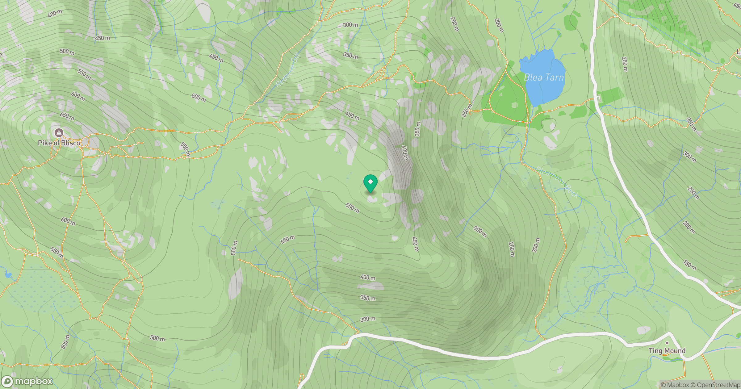
Grid reference: NY285039
View on OpenStreetMapOpens a map in a new tab, centred on the hill.

No comments yet. Be the first.