

Pike of Blisco
Good walks are even better shared.
Overview
Pike of Blisco is a 703-metre Wainwright above Great Langdale, with a rocky twin summit and approaches from Langdale and Wrynose Pass.
Pike of Blisco
Pike of Blisco is a 703-metre Wainwright with a cairned summit at NY 27119 04212. Summit record.
Its rocky crown stands above the southern side of Great Langdale. The climb from the valley is steep, with short scrambling sections near the top, so this is a mountain walk for sure-footed walkers. Mountain character.
The two summit cairns
The true summit is the north-western of the two rocky tops, marked by the larger cairn. The south-eastern top, roughly 90 metres away, is about three metres lower. Take care crossing the rocky ground between them, especially in cloud. Finding the summit.
Crinkle Crags and Bowfell make an impressive skyline close by, while the Langdale Pikes stand across the valley. Cold Pike rises beyond Red Tarn, with the Coniston fells farther south. Surrounding fells.
A circuit from Old Dungeon Ghyll
From Old Dungeon Ghyll, join the valley road and take the lane towards Blea Tarn, passing Wall End Farm. Partway up the steep road, turn right onto the signed fell path. Follow the rocky ascent towards the summit, allowing time for the short scrambles on the upper slopes. Langdale ascent.
From the main summit, the descent towards Red Tarn starts south before bending west. Check this departure carefully: paths around the twin tops are less obvious than the lower trails, and an incorrect line can lead onto steep rock. Summit navigation.
At Red Tarn, take the northward descent towards Browney Gill and Oxendale. Oxendale return.
Keep this separate from the path south to Wrynose Pass. At the valley bottom, cross the footbridge and follow the signed route through Stool End Farm. Continue along the farm lane back to Old Dungeon Ghyll to complete the circuit. Return through Stool End.
From Wrynose Pass and back
The Three Shire Stone at the top of Wrynose Pass gives a higher starting point. Follow the established path north towards Redtarn Moss and Red Tarn. Parts of this approach have stone-pitched steps. Wrynose approach.
Continue past Red Tarn, then turn right onto the steep path climbing Pike of Blisco. For a there-and-back walk, descend the same way to the tarn and retrace the approach south to Three Shire Stone. Stay on that return path rather than descending north into Oxendale. Route from Three Shire Stone.
Parking near Three Shire Stone is limited. Use a suitable space without obstructing the road, and carry your own food and drink. The high start reduces the climb but still leads onto rough mountain ground. Planning the high start.
Volcanic rock and a rocky landscape
Pike of Blisco belongs to the Borrowdale Volcanic Group. Around the fell, the Blisco Member contains volcanic ash deposits and sediment formed from reworked volcanic material, including sandstone and breccia. Andesite sheets occur above it. These rocks record both eruptions and the movement of debris across an ancient volcanic landscape. Local geology.
Parking, buses and facilities
For the Langdale circuit, use the National Trust car park at Old Dungeon Ghyll, NY 286 061. Check the current parking terms and payment arrangements. Public toilets are at the separate Stickle Ghyll car park farther down the valley. Keep dogs on leads around grazing livestock. Langdale visitor information.
The 516 bus connects Old Dungeon Ghyll with Ambleside. Check the timetable for your date, including the last return, before choosing a walking route. Do not plan around summer frequencies during the winter. 516 timetable.
Before setting out
Watch for traffic on road sections. Streams can rise quickly after rain; turn back if a crossing is unsafe or a footbridge unusable, rather than attempting a ford. Water and weather.
Check the mountain forecast and leave your route and expected return time with someone. Carry a map, compass, waterproofs, warm layers, food and drinking water, and leave enough daylight for the descent. Wet rock, high winds and snow or ice can make the upper fell much more serious. Be ready to turn back. Walking safety.
Explore routes near Pike of Blisco
Public walks starting within 80 km of this hill. Nearby does not mean a route reaches the summit; check its map and access before setting out.
Great Carrs Halifax Wreckage from Wrynose Pass
View route
Tarn Hows Fast Route
View route
Coniston to Tarn Hows: Monk Coniston Gardens and Woodland Circuit
View route
Scafell Pike from Seathwaite via the Corridor Route
View route
Route planning notes
These notes describe possible approaches, not verified navigable routes or permission to cross land. Check current paths, local access rules and conditions before setting out.
Old Dungeon Ghyll circuit
Climb via Wall End and the eastern fell path. Descend towards Red Tarn, turn north through Oxendale, and return via Stool End Farm to Old Dungeon Ghyll.
Wrynose Pass out-and-back
From Three Shire Stone follow the Red Tarn path, then climb Pike of Blisco. Return by the same path through Red Tarn to Wrynose Pass.
Make a day of it, together
Find someone to share the walk with, or organise a day out along a route you like.
Photo Gallery
View all Photo could not load
NY2704 : Approaching the Summit
Mick Garratt
 Photo could not load
NY2704 : Windshelter and Cairn, Pike o' Blisco
Michael Graham
 Photo could not load
NY2704 : On Pike of Blisco
Michael Graham
 Photo could not load
NY2704 : Pike of Blisco from near Stake Pass
David Purchase
 Photo could not load
NY2704 : Wind Shelter, Pike of Blisco
Michael Graham
 Photo could not load
NY2704 : Summit Cairn on Pike of Blisco
Anthony Parkes
 Photo could not load
NY2704 : Pike of Blisco Summit Cairn
Anthony Parkes
 Photo could not load
NY2704 : Summit cairn, Pike O'Blisco
Tom Richardson
 Photo could not load
NY2704 : Pike of Blisco and Blake Rigg from Oxen Fell
Karl and Ali

NY2704 : Rock strewn summit of Pike of Blisco
Peter Bond
Hill facts and local notes
Classifications
Elevation
703m
2,306 ft
Prominence
177m
Coordinates
54.4281, -3.1249
NY271042
OS Map
89 90
Explorer: OL6N
At the Summit
Larger cairn on the north-western rocky top; the south-eastern cairn is about 90 metres away and three metres lower.
Terrain & Geology
Borrowdale Volcanic Group: local rocks include andesite, volcanic tuffs and sedimentary beds made from reworked volcanic material in the Blisco Member.
Views & Scenery
Crinkle Crags, Bowfell, the Langdale Pikes, Cold Pike and the Coniston fells.
History & Heritage
Historical Significance
Pike o’Blisco is included in Book Four, The Southern Fells, of Wainwright’s pictorial guides.
Getting There & Facilities
Check current local access restrictions, parking rules and transport timetables before travelling. These notes do not confirm public access to the summit.
Parking
National Trust Old Dungeon Ghyll car park, NY 286 061, for the Langdale circuit. Check current parking terms.
Public Transport
Stagecoach 516 connects Old Dungeon Ghyll and Ambleside. Check the current timetable and last return for your travel date.
Nearby Facilities
Public toilets at Stickle Ghyll car park, a separate location farther down Great Langdale. Carry food and drinking water.
Safety Information
Known Hazards
- Steep rock and short scrambles around the summit; take care locating the descent in cloud.
- Wet rock and strong winds increase the risk of a fall.
- Road traffic on lane sections. Turn back at unsafe stream crossings or an unusable bridge; do not improvise a ford.
Seasonal Hazards
Snow and ice require winter skills and equipment. Short winter days leave less time for the return.
General Safety Tips
- Check weather conditions before setting out
- Carry appropriate clothing and equipment
- Let someone know your planned route
- Take a map, compass, and GPS device
- Carry emergency supplies: food, water, first aid kit, torch
Hills
Some common questions about the hills answered
Are there group walks up Pike of Blisco?
Many walkers use Walkmates to join or organise walks with others. You can check for group walks around Pike of Blisco through the maps
Are there other walkers around Pike of Blisco?
Activity varies by location and time, but Walkmates lets you see whether others have shared walks or shown interest in this area. Find other people through the walking friends search walking friends for Pike of Blisco search or of course create your own walk for Pike of Blisco
Can I organise a walk to Pike of Blisco?
Yes. If there aren’t any walks listed already, you can create a walk and make it available for others to join.
If you're signed up to Walkmates, you can create a walk to Pike of Blisco.
How do I find a walk up this hill?
There are often multiple ways to walk this hill, depending on experience and route preference. Walkmates helps you explore walks and routes that others have shared.
Can I suggest a new route up Pike of Blisco?
Yes. You can suggest or create routes to share with others. Walkmates focuses on the social side of walking, so routes are used to help people organise walks and explore areas together, rather than as detailed navigation tools or route libraries.
Other uses really appreciate knowledgeable walkers sharing their routes. Share your favourite route to Pike of Blisco here
The is an error or something incorrect about this hill. How do I let you know?
We always strive to keep the information on Walkmates as accurate as possible. If you find an error, please let us know through the contact form and we'll aim to correct it as quickly as possible
Community Discussion
Comments
Location
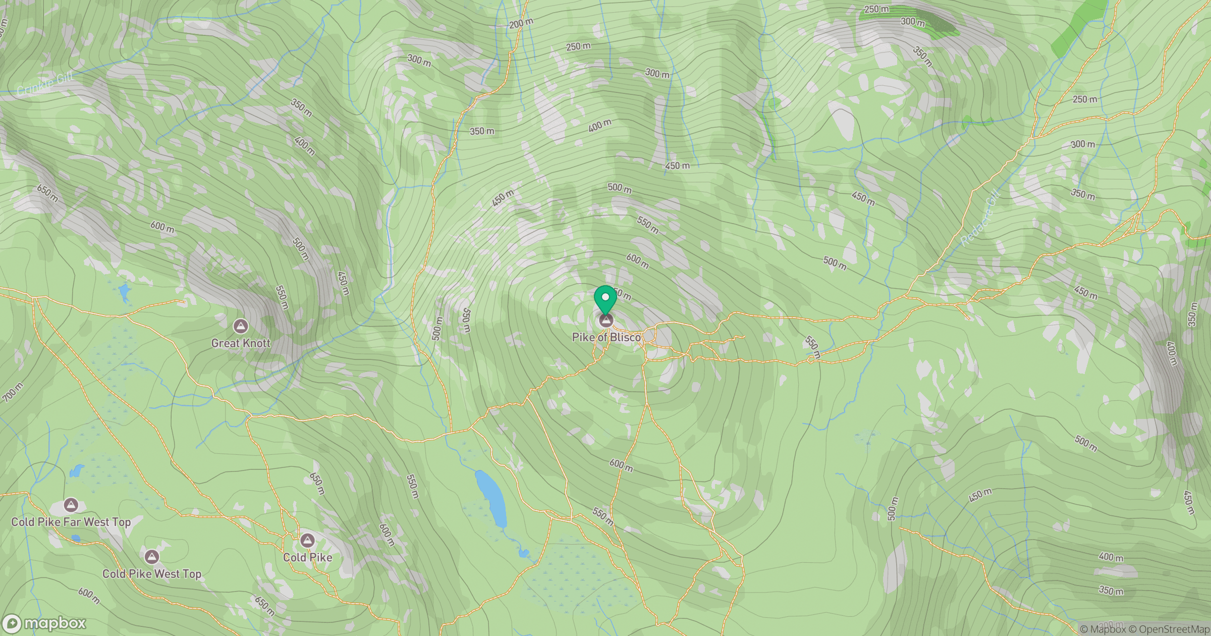
Grid reference: NY271042
View on OpenStreetMapOpens a map in a new tab, centred on the hill.
Hills within 30 km
Straight-line distance, not a walking route or confirmation of access.

Crinkle Crags - Long Top [Second Crinkle]
859m
Wetherlam
763m

Bowfell
903m

The Old Man of Coniston [Coniston Old Man]
802m
Dow Crag
778m
No comments yet. Be the first.