
Billinge Hill
Good walks are even better shared.
Overview
Billinge Hill: A Hidden Gem in North West England
Billinge Hill is an appealing destination for hikers and nature lovers alike, boasting an elevation of 192 meters. Residing in the heart of North West England, this marilyn offers not only a rewarding trek but also splendid landscapes that will make your camera work overtime.
Geology
Billinge Hill is predominantly sandstone, a rock that tells tales of ancient environments. As you hike, be ready to marvel at the intricate patterns and the flora that has taken root in this well-worn terrain.
Routes
Billinge Hill Circular Walk
Kick off from the village centre and take a leisurely 4.5 km stroll, which is a gentle jaunt perfect for families or those looking to stretch their legs without breaking a sweat.
Steeps and Peaks Trail
For those who fancy a bit of a challenge, this moderate 2.5 km ascent leads you up the northern slopes and has your quads crying for mercy by the summit.
Summit Features
The summit is crowned by a trig point, equivalent to a crown jewel for the hikers who reach the top. Keep your eyes peeled for the delightful viewfinder, ensuring your selfies are postcard-perfect.
Terrain
Enjoy grassy hillsides interspersed with rocky paths. This striking landscape provides a medium workout, allowing hikers to connect with nature while catching their breath.
Views
At the top, take a moment to soak in the stunning vistas that stretch all the way to Greater Manchester and Liverpool. On a clear day, the Welsh hills rear up on the horizon, showcasing the beauty of the British countryside.
Hazards
While Billinge Hill may seem inviting, do tread carefully. Wet paths can turn into slip-n-slide zones, so a sturdy pair of boots is a must-have.
Access
- Parking: Limited parking is available near Billinge Church.
- Public Transport: Buses run regularly from towns like Wigan and St Helens.
- Nearest Town: Both Wigan and St Helens are just a short journey away, offering a range of facilities.
Facilities
Post-hike, treat yourself at local pubs or cafes in Billinge, or make a pitstop at the public toilets available in the village.
History
The name 'Billinge' hints back to Old English, connecting us to the stories of our ancestors. It has served as a significant landmark for locals and visitors alike for centuries.
Conclusion
Billinge Hill is a delightful destination, ideal for hikers looking to revel in both nature and a bit of history. Whether you're hiking up for a workout or to take in the breathtaking views, you’ll find this little hill packs a big punch.
Happy hiking!
Explore routes near Billinge Hill
Walks starting near this hill. Open a route to check its map, distance and full itinerary.
county
View route
Brockholes Reserve Tour
View route
Brockholes Wildflower Year guided walk
View route
Brockholes Reserve Tour
View route
Route planning notes
These notes describe possible approaches. Check a route's map and access information when planning your walk.
Billinge Hill Circular Walk
A beautiful circular route starting from the village of Billinge, this trail takes you around the hill, allowing for scenic views and a pleasant hike.
Steeps and Peaks Trail
A more challenging ascent via the northern slopes, this route rewards hikers with stunning views of the surrounding countryside.
Make a day of it, together
Find someone to share the walk with, or organise a day out along a route you like.
Hill facts and local notes
Classifications
Elevation
179m
588 ft
Prominence
152m
Coordinates
53.5077, -2.7169
SD525014
OS Map
108
Explorer: 285E
At the Summit
The summit features a prominent trig point and an impressive viewfinder, perfect for spotting local landmarks - don’t be surprised if you engage in a staring contest with the horizon.
Terrain & Geology
Billinge Hill is primarily composed of sandstone, a sedimentary rock that has weathered into a rugged landscape over time, providing a rich tapestry of flora and fauna.
Views & Scenery
From the summit, you can enjoy panoramic views of Greater Manchester, Liverpool, and the surrounding countryside, plus a cheeky peek at the Welsh hills on a clear day.
History & Heritage
Name Origin
The name 'Billinge' derives from the Old English 'Billinga', which means a place associated with the people of Bill.
Historical Significance
Billinge Hill has been a local landmark for centuries and is often referenced in literature and local lore.
Getting There & Facilities
Parking
There is a small parking area near Billinge Church, suitable for a few cars. Alternatively, street parking is available in the village.
Public Transport
Regular bus services operate from Wigan and St Helens, making it accessible by public transport for day trippers.
Nearby Facilities
There are a few local pubs and cafes in Billinge, perfect for a post-hike pint or a warm cuppa. Public toilets are also available in the village.
Safety Information
Known Hazards
- Watch out for slippery paths, especially after rain, and be mindful of sudden changes in weather typical of the area.
General Safety Tips
- Check weather conditions before setting out
- Carry appropriate clothing and equipment
- Let someone know your planned route
- Take a map, compass, and GPS device
- Carry emergency supplies: food, water, first aid kit, torch
Hills
Some common questions about the hills answered
Are there group walks up Billinge Hill?
Many walkers use Walkmates to join or organise walks with others. You can check for group walks around Billinge Hill through the maps
Are there other walkers around Billinge Hill?
Activity varies by location and time, but Walkmates lets you see whether others have shared walks or shown interest in this area. Find other people through the walking friends search walking friends for Billinge Hill search or of course create your own walk for Billinge Hill
Can I organise a walk to Billinge Hill?
Yes. If there aren’t any walks listed already, you can create a walk and make it available for others to join.
If you're signed up to Walkmates, you can create a walk to Billinge Hill.
How do I find a walk up this hill?
There are often multiple ways to walk this hill, depending on experience and route preference. Walkmates helps you explore walks and routes that others have shared.
Can I suggest a new route up Billinge Hill?
Yes. You can suggest or create routes to share with others. Walkmates focuses on the social side of walking, so routes are used to help people organise walks and explore areas together, rather than as detailed navigation tools or route libraries.
Other uses really appreciate knowledgeable walkers sharing their routes. Share your favourite route to Billinge Hill here
The is an error or something incorrect about this hill. How do I let you know?
We always strive to keep the information on Walkmates as accurate as possible. If you find an error, please let us know through the contact form and we'll aim to correct it as quickly as possible
Community Discussion
Comments
Location
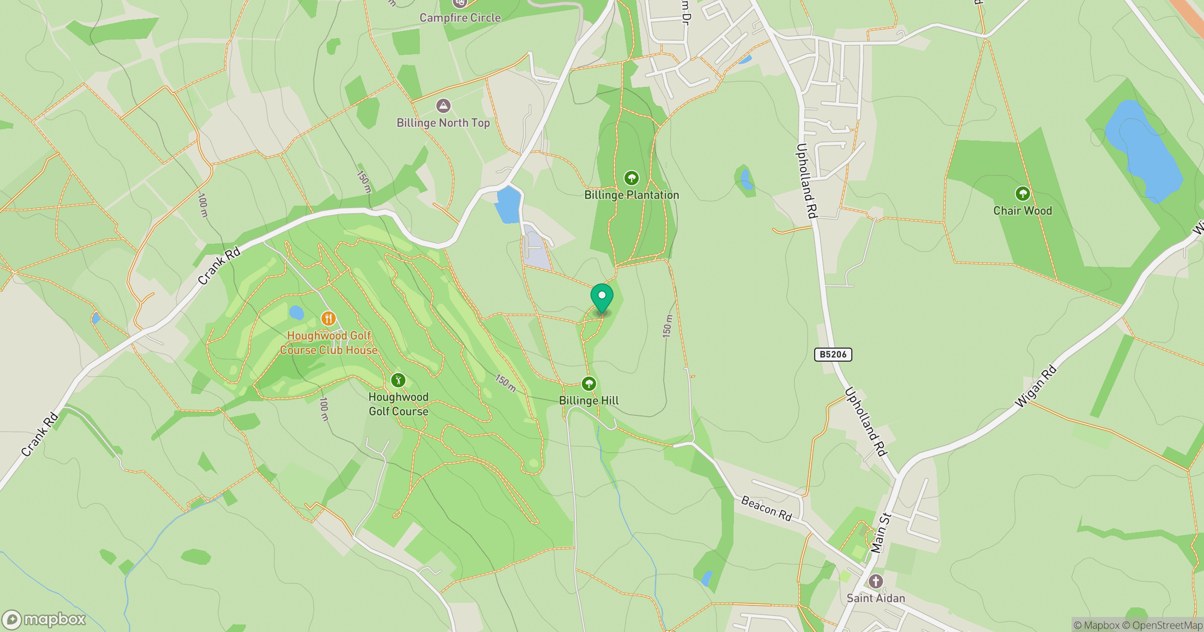
Grid reference: SD525014
View on OpenStreetMapOpens a map in a new tab, centred on the hill.



No comments yet. Be the first.