
Beinn Tarsuinn
Good walks are even better shared.
Overview
Beinn Tarsuinn: A Mountain of Many Sights
Overview
Beinn Tarsuinn, rising to 785 meters, is a splendid Munro located in the heart of the Scottish Highlands. Known for its stunning views and varied terrain, it is a beloved choice for both seasoned hikers and those looking to get their boots muddy for the first time.
Geology
The mountain is predominantly granite and boasts dramatic features shaped by glacial activity. As you climb, take note of the rocky outcrops and glacial striations—these tell the tale of the ancient ice that once covered this area. It’s a geologist’s dream!
Routes
The primary route to the summit begins in Glen Tarsuinn. This route, described above, winds through lush landscapes before leading to the more rugged, rocky terrain near the summit. Allow about 4.5 hours to complete your journey, making sure to take a breather to soak in the views.
Summit Features
Upon reaching the pinnacle, you will be greeted by a cairn, marking the summit where fellow outdoors enthusiasts often exchange tales of their adventures. Just make sure you don’t forget to snap a few photos before heading back down—Instagram won’t know what hit it!
Terrain Type
Expect a delightful mix of grassy slopes and rocky outcrops, accompanied by the occasional bog. Definitely wear your best waterproof boots; you never know when you might encounter a less-than-glamorous squelch!
Views
The vista from the summit is nothing short of spectacular. On a clear day, you’ll see Loch Fyne shimmering in the distance, the Paps of Jura looming majestically, and even the far reaches of the Arrochar Alps. The best times for breathtaking views are late spring and autumn when the landscape is bursting with colours.
Hazards
While navigating Beinn Tarsuinn, keep in mind the local inhabitants: midges. These tiny terrors can plague you in the summer months, so pack some insect repellent. Additionally, the weather can be as unpredictable as a cat on a hot tin roof, so come prepared for anything.
Nearby Summits
Beinn Tarsuinn is neighbours with several other prominent peaks, including Beinn Bhreac and Beinn Ime, both offering further hiking opportunities if you want to turn your day into an epic adventure.
Access
Parking is available at NR 911 449, but it’s limited, so arrive early to secure your spot. If you’re relying on public transport, be sure to check local schedules, as they can be a bit sparse.
Facilities
While the mountain itself lacks facilities, the nearby town of Dunoon has you covered with cafes and shops to prepare you for your hike or to provide refreshments afterward.
History
The name Beinn Tarsuinn, translating to 'Peak of the Crossing', hints at its historical significance as a landmark. The area’s rich history includes ancient settlements visible in the glens, offering a fascinating glimpse into the past.
Whether you're here for the thrill of climbing or simply to bask in nature’s glory, Beinn Tarsuinn promises an unforgettable experience. Lace up your hiking boots, grab your walking stick, and set off on an adventure to remember!
Explore routes near Beinn Tarsuinn
Public walks starting within 80 km of this hill. Nearby does not mean a route reaches the summit; check its map and access before setting out.
Goatfell from Cladach
View route
Bishop’s Glen group walk
View route
West Bay walk and talk
View route
West Bay walk and talk
View route
Route planning notes
These notes describe possible approaches, not verified navigable routes or permission to cross land. Check current paths, local access rules and conditions before setting out.
Beinn Tarsuinn via Glen Tarsuinn
A pleasant trek that meanders through lush glen and opens up to rugged terrain as you ascend the mountain, offering a delightful variety of scenery.
Make a day of it, together
Find someone to share the walk with, or organise a day out along a route you like.
Hill facts and local notes
Classifications
Elevation
556m
1,824 ft
Prominence
148m
Coordinates
55.6559, -5.2909
NR930451
OS Map
62 69
Explorer: 361N
At the Summit
The summit features a stone cairn and offers ample space to enjoy the panoramic views. Watch out for the sneaky midges during summer!
Terrain & Geology
Composed primarily of granite, Beinn Tarsuinn showcases striking features formed during the last Ice Age, with glacial striations and rocky outcrops that would make any geology enthusiast swoon.
Views & Scenery
From the summit, one can witness breathtaking views of Loch Fyne, the Paps of Jura, and, on a clear day, the distant peaks of the Arrochar Alps.
History & Heritage
Name Origin
The name Beinn Tarsuinn translates from Gaelic as 'Peak of the Crossing', possibly referring to its position as a landmark in the landscape.
Historical Significance
Historically, the area around Beinn Tarsuinn has been inhabited for thousands of years, with nearby ancient settlements visible in the lower glens.
Getting There & Facilities
Check current local access restrictions, parking rules and transport timetables before travelling. These notes do not confirm public access to the summit.
Parking
There is a small parking area at the end of the approach road at NR 911 449.
Public Transport
Public transport is limited, but buses from nearby villages serve the region intermittently. Be sure to check local schedules.
Nearby Facilities
There are no facilities on the mountain itself, but Dunoon offers cafes, shops, and public toilets for all your needs pre- and post-hike.
Safety Information
Known Hazards
- Midges in the summer months can be relentless; remember to bring spray. The weather can change rapidly, so be prepared for sudden showers.
General Safety Tips
- Check weather conditions before setting out
- Carry appropriate clothing and equipment
- Let someone know your planned route
- Take a map, compass, and GPS device
- Carry emergency supplies: food, water, first aid kit, torch
Hills
Some common questions about the hills answered
Are there group walks up Beinn Tarsuinn?
Many walkers use Walkmates to join or organise walks with others. You can check for group walks around Beinn Tarsuinn through the maps
Are there other walkers around Beinn Tarsuinn?
Activity varies by location and time, but Walkmates lets you see whether others have shared walks or shown interest in this area. Find other people through the walking friends search walking friends for Beinn Tarsuinn search or of course create your own walk for Beinn Tarsuinn
Can I organise a walk to Beinn Tarsuinn?
Yes. If there aren’t any walks listed already, you can create a walk and make it available for others to join.
If you're signed up to Walkmates, you can create a walk to Beinn Tarsuinn.
How do I find a walk up this hill?
There are often multiple ways to walk this hill, depending on experience and route preference. Walkmates helps you explore walks and routes that others have shared.
Can I suggest a new route up Beinn Tarsuinn?
Yes. You can suggest or create routes to share with others. Walkmates focuses on the social side of walking, so routes are used to help people organise walks and explore areas together, rather than as detailed navigation tools or route libraries.
Other uses really appreciate knowledgeable walkers sharing their routes. Share your favourite route to Beinn Tarsuinn here
The is an error or something incorrect about this hill. How do I let you know?
We always strive to keep the information on Walkmates as accurate as possible. If you find an error, please let us know through the contact form and we'll aim to correct it as quickly as possible
Community Discussion
Comments
Location
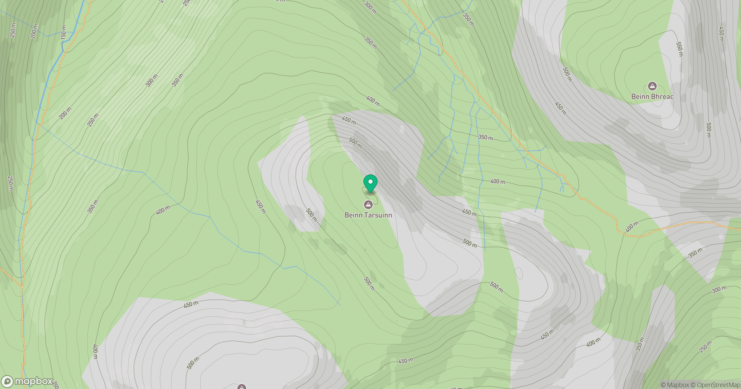
Grid reference: NR930451
View on OpenStreetMapOpens a map in a new tab, centred on the hill.
Hills within 30 km
Straight-line distance, not a walking route or confirmation of access.
No comments yet. Be the first.