

Tomies Mountain North Top
Good walks are even better shared.
V8987 : On Tomies Mountain N Top - view to Tomies Mountain & Purple Mountain
Colin Park Photo source
Overview
Tomies Mountain North Top
Tomies Mountain North Top stands proudly at an elevation of 708 meters, part of the scenic Kerry Mountains in southwestern Ireland. It is one of those peaks that invites both seasoned walkers and those who merely wish to enjoy a good view while trying to justify an ice cream afterwards.
Geology
The bedrock here consists primarily of granite and schist, contributing to the rugged beauty of the terrain. A walk through this geological marvel is akin to strolling through ancient history, albeit one where there are no dinosaurs (sorry to disappoint!).
Routes
For those eager to conquer the North Top, the Tomies Wood Loop is a delightful option. This moderate route spans approximately 6.5 km, taking around 2.5 hours to complete. It meanders through vibrant woodlands before presenting a challenging ascent adorned with those charming rocky outcrops.
Summit Features
Upon reaching the summit, you'll be greeted by a noteworthy cairn, perfect for a quick selfie and maybe even a victory dance if you're feeling cheeky. The sweeping views from this lofty perch certainly justify the hike.
Terrain
Get ready for a mixed bag: grassy slopes complemented by rocky patches. And just for fun – there might be a few boggy bits that could use your best dancing moves to navigate!
Views
The summit rewards climbers with breathtaking sights of the Gap of Dunloe, the glorious MacGillycuddy's Reeks, and sparkling lakes – all begging for a spot on your Facebook album. The best time to experience this spectacle is during spring and early autumn when the visibility is at its prime.
Hazards
As with any mountain venture, be cautious of slippery sections, especially after rain. It's more fun to hike than to slip and potentially create a dramatic (albeit embarrassing) summit story!
Nearby Summits
After conquering Tomies Mountain North Top, why not test your mettle on Tomies Mountain South Top (703 m) or Mangerton Mountain (839 m)? The views just keep getting better!
Access
You'll find ample parking at the entrance to Tomies Wood, just 2 km away from the quaint village of Beaufort. If you're inclined to rely on public transport, buses to Killarney are your best bet, followed by a taxi to the trailhead.
Facilities
Once you’ve descended, treat yourself at a local cafe or pub in Beaufort – because let’s be honest, you’ve earned that slice of cake!
History
As for the name, 'Tomies' comes from the Irish term for hill, making it quite the straightforward moniker for this elevated beauty. Historically, the mountain carries cultural significance for the local community, further enchanting its natural allure.
So lace up those boots, pack a sandwich and maybe a cheeky flask of tea, and set off for a thrilling day at Tomies Mountain North Top!
Explore routes near Tomies Mountain North Top
Walks starting near this hill. Open a route to check its map, distance and full itinerary.
Route planning notes
These notes describe possible approaches. Check a route's map and access information when planning your walk.
Tomies Wood Loop
A scenic circular route starting from the car park near Tomies Wood, weaving through lush forestry before ascending towards the summit.
Make a day of it, together
Find someone to share the walk with, or organise a day out along a route you like.
Photo Gallery
View all Photo could not load
V8987 : On Tomies Mountain N Top - view to Tomies Mountain & Purple Mountain
Colin Park
 Photo could not load
V8987 : View towards Lough Leane from Tomies Mountain N Top
Colin Park
Hill facts and local notes
Classifications
Elevation
566m
1,857 ft
Prominence
22m
Coordinates
52.0280, -9.6165
V891874
OS Map
78
At the Summit
The summit features a prominent cairn, offering a perfect photo op for both aspiring mountaineers and well-nourished couch potatoes alike.
Terrain & Geology
The geology of Tomies Mountain North Top predominantly consists of granite and schist, which provide a striking appearance and are reflective of the region's ancient geological history.
Views & Scenery
From the summit, enjoy panoramic views of the Gap of Dunloe, the distant peaks of the MacGillycuddy's Reeks, and the beautiful lakes below.
History & Heritage
Name Origin
The name Tomies derives from the Irish 'Tomais', meaning 'hill', a rather fitting name if ever there was one.
Historical Significance
This mountain holds cultural significance in the local area and offers insight into the region's expansive natural beauty.
Getting There & Facilities
Parking
There is a car park located at the entrance to Tomies Wood, approximately 2 km from the village of Beaufort.
Public Transport
The nearest public transport can be accessed via bus services to Killarney, followed by a taxi to Beaufort.
Nearby Facilities
While there are no facilities on the mountain itself, nearby Beaufort provides options such as cafes, pubs, and public toilets.
Safety Information
Known Hazards
- Be aware of sections that can be slippery when wet, and always watch your step around rocky outcrops.
General Safety Tips
- Check weather conditions before setting out
- Carry appropriate clothing and equipment
- Let someone know your planned route
- Take a map, compass, and GPS device
- Carry emergency supplies: food, water, first aid kit, torch
Hills
Some common questions about the hills answered
Are there group walks up Tomies Mountain North Top?
Many walkers use Walkmates to join or organise walks with others. You can check for group walks around Tomies Mountain North Top through the maps
Are there other walkers around Tomies Mountain North Top?
Activity varies by location and time, but Walkmates lets you see whether others have shared walks or shown interest in this area. Find other people through the walking friends search walking friends for Tomies Mountain North Top search or of course create your own walk for Tomies Mountain North Top
Can I organise a walk to Tomies Mountain North Top?
Yes. If there aren’t any walks listed already, you can create a walk and make it available for others to join.
If you're signed up to Walkmates, you can create a walk to Tomies Mountain North Top.
How do I find a walk up this hill?
There are often multiple ways to walk this hill, depending on experience and route preference. Walkmates helps you explore walks and routes that others have shared.
Can I suggest a new route up Tomies Mountain North Top?
Yes. You can suggest or create routes to share with others. Walkmates focuses on the social side of walking, so routes are used to help people organise walks and explore areas together, rather than as detailed navigation tools or route libraries.
Other uses really appreciate knowledgeable walkers sharing their routes. Share your favourite route to Tomies Mountain North Top here
The is an error or something incorrect about this hill. How do I let you know?
We always strive to keep the information on Walkmates as accurate as possible. If you find an error, please let us know through the contact form and we'll aim to correct it as quickly as possible
Community Discussion
Comments
Location
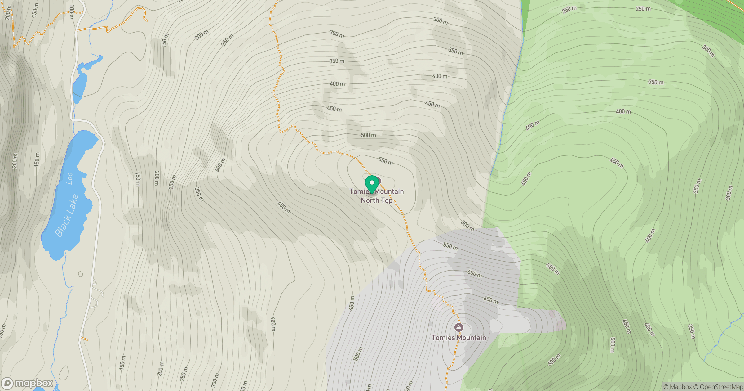
Grid reference: V891874
View on OpenStreetMapOpens a map in a new tab, centred on the hill.
No comments yet. Be the first.