
Knockshanawee
Good walks are even better shared.
Overview
Knockshanawee: A Hidden Gem Amongst the Bluestacks
Knockshanawee, although not the tallest within the Bluestack Mountains, offers a rewarding outing for hikers and nature lovers alike. With an elevation of 593 meters, the mountain may not break any height records, but what it lacks in stature, it more than makes up for in stunning vistas and charming terrain.
Geology
The geology of Knockshanawee is a testament to the ancient forces that shaped this part of Ireland. Composed mainly of granite and schist, the rocky outcrops provide a striking contrast to the soft greens of the grasslands surrounding them. As you ascend, take a moment to observe the varying rock formations that tell a story of ancient glacial activity, a history etched in stone.
Route Info
The most common route starts from the Bluestack Way, which meanders through the lush lowlands before starting its ascent. It is a moderate trek, approximately 9 kilometers round-trip, taking around 3.5 hours to complete, making it suitable for both seasoned hikers and those just looking for a pleasant day out.
Summit Features
Reaching the summit, hikers are greeted by a modest stone cairn, which serves not only as a milestone of your accomplishments but also as a perfect perch for a photo op. Don’t miss the chance to capture your triumph and perhaps share it with the world.
Terrain
Expect a mixture of grassy expanses interspersed with rocky outcrops. The lower trails can be, at times, boggy – a classic feature of Irish outdoors, turning the unwary hiker into a temporary mud monster if they're not careful.
Stunning Views
Once at the top, the panoramic views will take your breath away. The rolling hills of County Donegal stretch out like a green patchwork quilt, dotted with lakes reflecting the sky. On clear days, the Atlantic Ocean twinkles invitingly, reminding all who gaze upon it of the wild beauty of the Irish coast.
Hazards
Be mindful of loose rocks near the summit; a tumble could lead to an unexpected sit-down on the rocky ground. The bogs at lower elevations may be misleading, appearing innocuous yet threatening to suck you in unexpectedly!
Access and Facilities
Glenties, the nearest town, serves as a wonderful gateway to your adventure, providing ample options for cafes and engagement with the lovely local folk, who have a story or two to share about this enchanting region. Parking can be found near the trailhead, but options are limited, so arriving early is wise.
Conclusion
Knockshanawee may not be a heavyweight, but it has a heart filled with nature's beauty and stories waiting to be uncovered. Don't underestimate a good hike simply because it's not a towering giant; in the realm of outdoor adventures, it's the journey and the laughter shared that create lasting memories. Happy hiking!
Explore routes near Knockshanawee
Public walks starting within 80 km of this hill. Nearby does not mean a route reaches the summit; check its map and access before setting out.
No public routes are currently listed within 80 km of Knockshanawee on Walkmates. This does not mean there are no paths here. Explore the map and check local access information before planning a walk.
Route planning notes
These notes describe possible approaches, not verified navigable routes or permission to cross land. Check current paths, local access rules and conditions before setting out.
Bluestack Way Route
A well-marked path leading up from the foothills, offering a gradient that will make you feel like you're either conquering a mountain or just out for a leisurely stroll, depending on your pace.
Make a day of it, together
Find someone to share the walk with, or organise a day out along a route you like.
Hill facts and local notes
Classifications
Elevation
209m
686 ft
Prominence
132m
Coordinates
51.8693, -8.7920
W455688
OS Map
86
At the Summit
At the summit, you will find a modest stone cairn, perfect for a celebratory photograph. Don't forget to wave at the sheep; they're the true locals!
Terrain & Geology
Knockshanawee is primarily composed of ancient granite and schists, providing a fascinating glimpse into the geological history of Ireland, with some delightful glacial valleys nearby.
Views & Scenery
From the summit, adventurers are treated to spectacular views of the surrounding Bluestack Mountains and the rolling countryside of County Donegal. On a clear day, the Atlantic shimmer is simply breathtaking.
History & Heritage
Name Origin
The name Knockshanawee is believed to derive from Gaelic, meaning 'hill of the desert' or 'barren hill', which is a charming nod to the sparse vegetation typically found at the peak.
Historical Significance
Knockshanawee is part of the rich tapestry of Irish mythology and folklore. It's said that many local stories revolve around the hills and the spirits that call them home.
Getting There & Facilities
Check current local access restrictions, parking rules and transport timetables before travelling. These notes do not confirm public access to the summit.
Parking
There is a small car park at the trailhead near the town of Glenties. It can accommodate around 10 vehicles. Arrive early during peak season to ensure a spot!
Public Transport
Buses run from Donegal Town to Glenties, with limited schedules; it’s advisable to check the timetables in advance.
Nearby Facilities
While there are no facilities directly on the mountain, Glenties offers several cafes and small shops for supplies and refreshments post-hike. The local friendly folks might also entice you into a good chat.
Safety Information
Known Hazards
- Loose rocks near the summit can be treacherous, and boggy areas at lower elevations can be rather deceptive, so be sure to watch your step!
General Safety Tips
- Check weather conditions before setting out
- Carry appropriate clothing and equipment
- Let someone know your planned route
- Take a map, compass, and GPS device
- Carry emergency supplies: food, water, first aid kit, torch
Hills
Some common questions about the hills answered
Are there group walks up Knockshanawee?
Many walkers use Walkmates to join or organise walks with others. You can check for group walks around Knockshanawee through the maps
Are there other walkers around Knockshanawee?
Activity varies by location and time, but Walkmates lets you see whether others have shared walks or shown interest in this area. Find other people through the walking friends search walking friends for Knockshanawee search or of course create your own walk for Knockshanawee
Can I organise a walk to Knockshanawee?
Yes. If there aren’t any walks listed already, you can create a walk and make it available for others to join.
If you're signed up to Walkmates, you can create a walk to Knockshanawee.
How do I find a walk up this hill?
There are often multiple ways to walk this hill, depending on experience and route preference. Walkmates helps you explore walks and routes that others have shared.
Can I suggest a new route up Knockshanawee?
Yes. You can suggest or create routes to share with others. Walkmates focuses on the social side of walking, so routes are used to help people organise walks and explore areas together, rather than as detailed navigation tools or route libraries.
Other uses really appreciate knowledgeable walkers sharing their routes. Share your favourite route to Knockshanawee here
The is an error or something incorrect about this hill. How do I let you know?
We always strive to keep the information on Walkmates as accurate as possible. If you find an error, please let us know through the contact form and we'll aim to correct it as quickly as possible
Community Discussion
Comments
Location
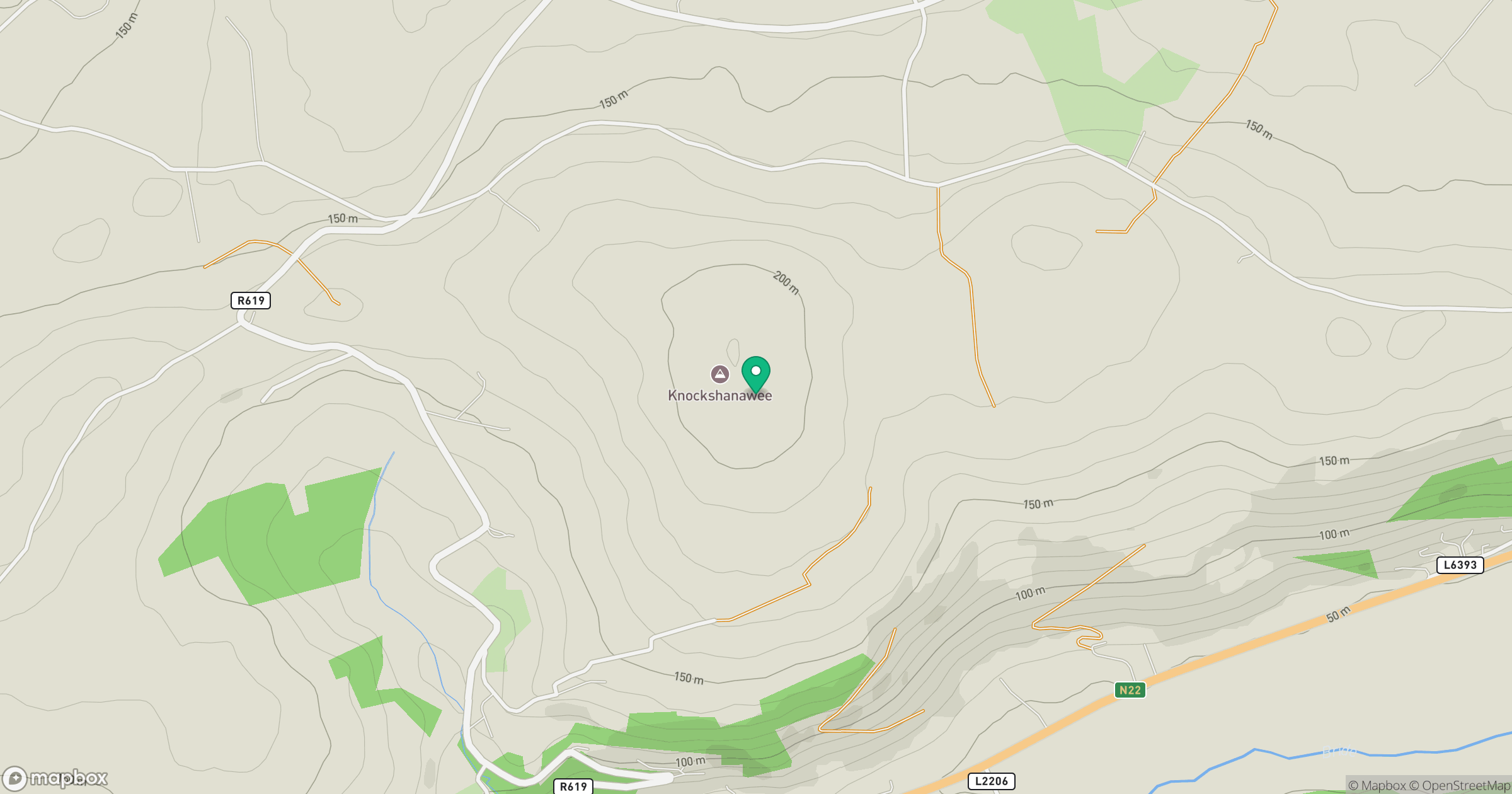
Grid reference: W455688
View on OpenStreetMapOpens a map in a new tab, centred on the hill.
Hills within 30 km
Straight-line distance, not a walking route or confirmation of access.
Knockagreenan
263m
Clearagh Hill
287m
Slieveadrohid [Hare Hill]
201m
Musheramore [Muisire Mor]
643m
Currane Hill
228m
No comments yet. Be the first.