
Knockagreenan
Good walks are even better shared.
Overview
Knockagreenan: A Hidden Gem in the Irish Hills
Knockagreenan stands proudly at 487 meters, making it a prominent feature in the Southern Irish landscape. While perhaps not as renowned as the higher peaks, its charm lies in its accessibility and the stunning views it offers.
Geology
The mountain is primarily composed of Old Red Sandstone, a geological marvel that's over 400 million years old! This reddish rock adds an intriguing touch to the scenery and is a favourite among geology enthusiasts.
The Routes
Trail from Kilgobnet
Starting in the quaint village of Kilgobnet, this moderate trail spans about 6.5 km, winding through verdant valleys before making a steady ascent to the summit. Expect to take around 2.5 hours to reach the top, depending on your pace (and how many photos you take!).
Summit Features
At the summit, hikers are greeted by a striking trig point, which is the perfect backdrop for your holiday snaps. The expansive views from here are nothing short of jaw-dropping.
Terrain Type
The terrain is a mix of grassy slopes interspersed with rocky outcrops. It’s pretty straightforward for anyone familiar with hillwalking, though a sturdy pair of boots is always wise to pack.
Views
From the summit, you’ll be treated to some of the finest vistas in Ireland. Gaze upon the Caha Mountains and—if you’re lucky—a glimpse of the Atlantic Ocean in the far distance. The best times to experience these views are in the spring and autumn when the skies are often clearer.
Hazards
As with all hills, weather can be unpredictable, so bundle up and come prepared for anything Mother Nature throws your way. Also, keep an eye out for those boggy patches that may lurk in the shadows—they love a good ambush!
Nearby Summits
If you’re keen for more adventures, consider hiking nearby Knockbrack (469 meters) or the Caha Mountains, which reach elevations of up to 700 meters.
Access
The nearest parking is a small layby near Kilgobnet, with the option to park at local farms with a heads-up. Public transport is limited, so it’s best to plan ahead. Kenmare, just 15 km away, is your nearest town, bustling with cafes and pubs for a well-deserved hearty meal—and a proper Irish coffee, of course.
History
The name 'Knockagreenan' comes from the Irish phrase 'Cnoc na gCrón', translating to 'hill of the green one'. Beyond its scenic beauty, this hill holds a special place in local culture as part of the ‘Wild Atlantic Way’, a route celebrated for its rich history and breathtaking views.
To wrap it all up, Knockagreenan may not be the tallest peak, but it is a delightful trek that combines natural beauty, a touch of geological wonder, and a friendly local ambience. So grab your hiking boots, pack some snacks, and set out for an adventure worth remembering!
Be safe, take your time, and enjoy the journey.
Explore routes near Knockagreenan
Public walks starting within 80 km of this hill. Nearby does not mean a route reaches the summit; check its map and access before setting out.
No public routes are currently listed within 80 km of Knockagreenan on Walkmates. This does not mean there are no paths here. Explore the map and check local access information before planning a walk.
Route planning notes
These notes describe possible approaches, not verified navigable routes or permission to cross land. Check current paths, local access rules and conditions before setting out.
Trail from Kilgobnet
A scenic route starting from the village of Kilgobnet that takes you through lush green valleys before ascending towards the summit.
Make a day of it, together
Find someone to share the walk with, or organise a day out along a route you like.
Hill facts and local notes
Classifications
Elevation
263m
863 ft
Prominence
146m
Coordinates
51.9137, -8.8698
W402738
OS Map
80
At the Summit
The summit features a prominent trig point which is a great spot for that obligatory selfie, along with breathtaking views of the surrounding landscape.
Terrain & Geology
The mountain is predominantly composed of Old Red Sandstone, which gives it a distinct reddish hue. This type of rock is over 400 million years old and is not only fascinating for geologists but can also make for some great conversation on a summit!
Views & Scenery
From the summit, you can enjoy panoramic views of the Caha Mountains, the distant Ring of Kerry, and, on a clear day, even the Atlantic Ocean in the far distance.
History & Heritage
Name Origin
The name 'Knockagreenan' derives from the Irish 'Cnoc na gCrón', which translates to 'hill of the green one'.
Historical Significance
Locals hold Knockagreenan in high regard, as it is a part of the ‘Wild Atlantic Way’, a cultural route that reflects the rich heritage of the region.
Getting There & Facilities
Check current local access restrictions, parking rules and transport timetables before travelling. These notes do not confirm public access to the summit.
Parking
There is a small layby near Kilgobnet, suitable for a few cars. Alternatively, local farms may allow parking with prior arrangement.
Public Transport
Public transport is limited; the nearest bus service is from Kenmare, about 15 km away.
Nearby Facilities
In Kenmare, there are several cafes, pubs, and toilets available for refreshment and rest before or after your hike.
Safety Information
Known Hazards
- Weather can change rapidly, so be prepared for all sorts of conditions. The terrain can be uneven, and be wary of boggy patches.
General Safety Tips
- Check weather conditions before setting out
- Carry appropriate clothing and equipment
- Let someone know your planned route
- Take a map, compass, and GPS device
- Carry emergency supplies: food, water, first aid kit, torch
Hills
Some common questions about the hills answered
Are there group walks up Knockagreenan?
Many walkers use Walkmates to join or organise walks with others. You can check for group walks around Knockagreenan through the maps
Are there other walkers around Knockagreenan?
Activity varies by location and time, but Walkmates lets you see whether others have shared walks or shown interest in this area. Find other people through the walking friends search walking friends for Knockagreenan search or of course create your own walk for Knockagreenan
Can I organise a walk to Knockagreenan?
Yes. If there aren’t any walks listed already, you can create a walk and make it available for others to join.
If you're signed up to Walkmates, you can create a walk to Knockagreenan.
How do I find a walk up this hill?
There are often multiple ways to walk this hill, depending on experience and route preference. Walkmates helps you explore walks and routes that others have shared.
Can I suggest a new route up Knockagreenan?
Yes. You can suggest or create routes to share with others. Walkmates focuses on the social side of walking, so routes are used to help people organise walks and explore areas together, rather than as detailed navigation tools or route libraries.
Other uses really appreciate knowledgeable walkers sharing their routes. Share your favourite route to Knockagreenan here
The is an error or something incorrect about this hill. How do I let you know?
We always strive to keep the information on Walkmates as accurate as possible. If you find an error, please let us know through the contact form and we'll aim to correct it as quickly as possible
Community Discussion
Comments
Location
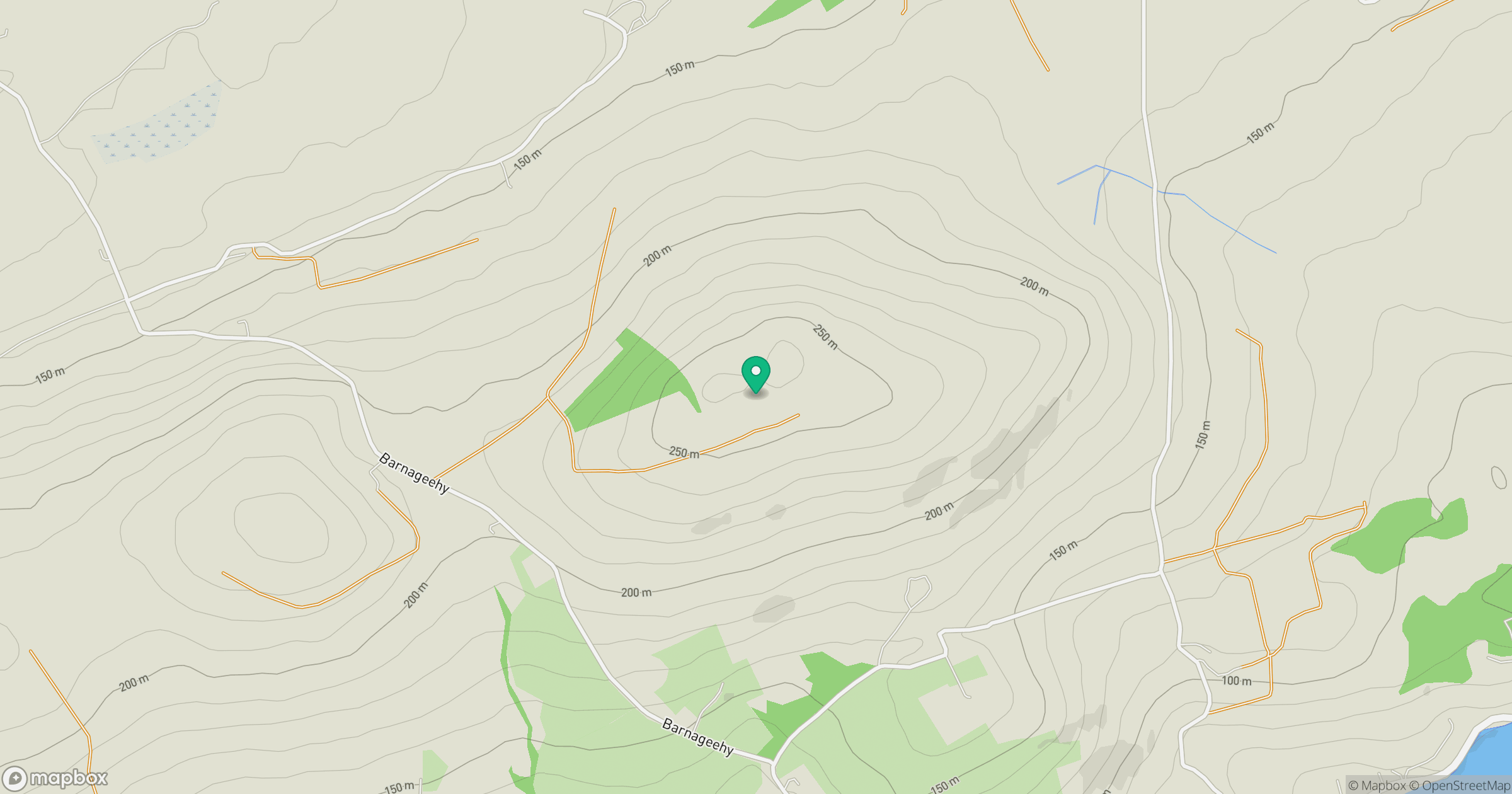
Grid reference: W402738
View on OpenStreetMapOpens a map in a new tab, centred on the hill.
Hills within 30 km
Straight-line distance, not a walking route or confirmation of access.
No comments yet. Be the first.