
Church Mountain
Good walks are even better shared.
Overview
Church Mountain
Nestled in the heart of the Lake District, Church Mountain stands at a modest 512 meters but offers experiences that soar far above its height. Known to locals and hikers, this peak is a delightful destination for those seeking a day out in nature.
Geology
As you tread the path, you'll notice the layered sandstone and shale that make up this mountain. These formations tell a tale of ancient seas and the relentless forces that shaped this landscape over eons. You'll be walking on history—don't forget to thank the rocks!
Routes
There are several routes that wind their way up Church Mountain. The Thornthwaite Crag Route is the most popular, providing a moderate challenge with spectacular vistas. For families or those looking for a gentler stroll, the Hollin Crag Path is an easy trek through lush woods, perfect for wildlife spotting.
Summit Features
Upon reaching the summit, you're greeted by a sturdy cairn, a hallmark of many a well-trodden path. There's also a trig point, marking this unique vantage point where you can look across the rolling hills and valleys.
Terrain
Expect a mix of rocky outcrops and grassy stretches, with the beautiful heather adding a touch of colour, particularly in late summer. Do mind the muddy patches after a good downpour—wet feet are not just a phrase!
Views
The summit offers breathtaking views; the landscape stretches out, revealing both the picturesque valleys below and the winding paths of the Lake District. The best time to visit for photography or simply soaking in the sights is in spring or autumn, when nature is at its most vibrant. And if you're an early riser, sunrise hikes can provide heart-thumping beauty beyond comparison!
Hazards
While the trek is accessible, caution is advised on the rocky bits. Loose stones can catch you off-guard, and muddy trails are not a place for fancy shoes. Waterproof gear is a wise choice!
Access
Getting to Church Mountain is straightforward. The nearest parking is at Thornthwaite, handy for hikers making their way here. And if you're relying on buses, the short trip from Keswick is quite picturesque!
Facilities
Basic amenities can be found at Thornthwaite, but for a proper brunch or toilet break, head over to Keswick where options abound for hungry hikers.
History
The name Church Mountain isn't just for show. It refers to the historical church nearby, hinting at the area's spiritual importance. This mountain has guided many on their journeys over centuries, making it a truly special destination.
So lace up those boots and make your way to Church Mountain—adventures await at every turn!
Explore routes near Church Mountain
Public walks starting within 80 km of this hill. Nearby does not mean a route reaches the summit; check its map and access before setting out.
No public routes are currently listed within 80 km of Church Mountain on Walkmates. This does not mean there are no paths here. Explore the map and check local access information before planning a walk.
Route planning notes
These notes describe possible approaches, not verified navigable routes or permission to cross land. Check current paths, local access rules and conditions before setting out.
Thornthwaite Crag Route
A moderately challenging trek starting from the car park near Thornthwaite, this route provides a blend of scenic views and steep ascents leading to the summit.
Hollin Crag Path
An easier path suitable for families, the Hollin Crag Path winds through beautiful woodlands, perfect for spotting wildlife along the way.
Make a day of it, together
Find someone to share the walk with, or organise a day out along a route you like.
Hill facts and local notes
Classifications
Elevation
543m
1,781 ft
Prominence
131m
Coordinates
53.0539, -6.5858
N948012
OS Map
56
At the Summit
The summit is adorned with a small, sturdy cairn built by the many hikers who have ventured to the top. A nearby trig point serves as a reminder of the surveying history of this stunning region.
Terrain & Geology
Church Mountain is primarily composed of sedimentary rocks, particularly sandstone and shale, which were laid down in the ancient seas that covered this area millions of years ago. The characteristic ruggedness of the terrain owes itself to glacial activity that sculpted the mountain's features during the last Ice Age.
Views & Scenery
From the summit, you can relish fantastic views of the surrounding valleys, wind-swept fells, and occasionally catch a glimpse of the distant Mersey estuary.
History & Heritage
Name Origin
The name 'Church Mountain' likely derives from the nearby historic church situated at the base, emphasising the area's spiritual significance.
Historical Significance
Church Mountain has been a local landmark for centuries, and its scenic beauty has drawn both pilgrims and outdoor enthusiasts alike throughout history.
Getting There & Facilities
Check current local access restrictions, parking rules and transport timetables before travelling. These notes do not confirm public access to the summit.
Parking
The nearest parking area is located at Thornthwaite, where a small car park accommodates visitors (postcode CA12 5TA).
Public Transport
Regular buses run from Keswick to Thornthwaite, making it easily accessible for those relying on public transport.
Nearby Facilities
There are limited facilities at Thornthwaite, but Keswick offers plenty of cafes, shops, and public toilets for visitors to enjoy pre- or post-hike refreshments.
Safety Information
Known Hazards
- Care should be taken on the rocky summit as loose stones can pose a slipping hazard. In wet conditions, trails can become muddy and treacherous.
General Safety Tips
- Check weather conditions before setting out
- Carry appropriate clothing and equipment
- Let someone know your planned route
- Take a map, compass, and GPS device
- Carry emergency supplies: food, water, first aid kit, torch
Hills
Some common questions about the hills answered
Are there group walks up Church Mountain?
Many walkers use Walkmates to join or organise walks with others. You can check for group walks around Church Mountain through the maps
Are there other walkers around Church Mountain?
Activity varies by location and time, but Walkmates lets you see whether others have shared walks or shown interest in this area. Find other people through the walking friends search walking friends for Church Mountain search or of course create your own walk for Church Mountain
Can I organise a walk to Church Mountain?
Yes. If there aren’t any walks listed already, you can create a walk and make it available for others to join.
If you're signed up to Walkmates, you can create a walk to Church Mountain.
How do I find a walk up this hill?
There are often multiple ways to walk this hill, depending on experience and route preference. Walkmates helps you explore walks and routes that others have shared.
Can I suggest a new route up Church Mountain?
Yes. You can suggest or create routes to share with others. Walkmates focuses on the social side of walking, so routes are used to help people organise walks and explore areas together, rather than as detailed navigation tools or route libraries.
Other uses really appreciate knowledgeable walkers sharing their routes. Share your favourite route to Church Mountain here
The is an error or something incorrect about this hill. How do I let you know?
We always strive to keep the information on Walkmates as accurate as possible. If you find an error, please let us know through the contact form and we'll aim to correct it as quickly as possible
Community Discussion
Comments
Location
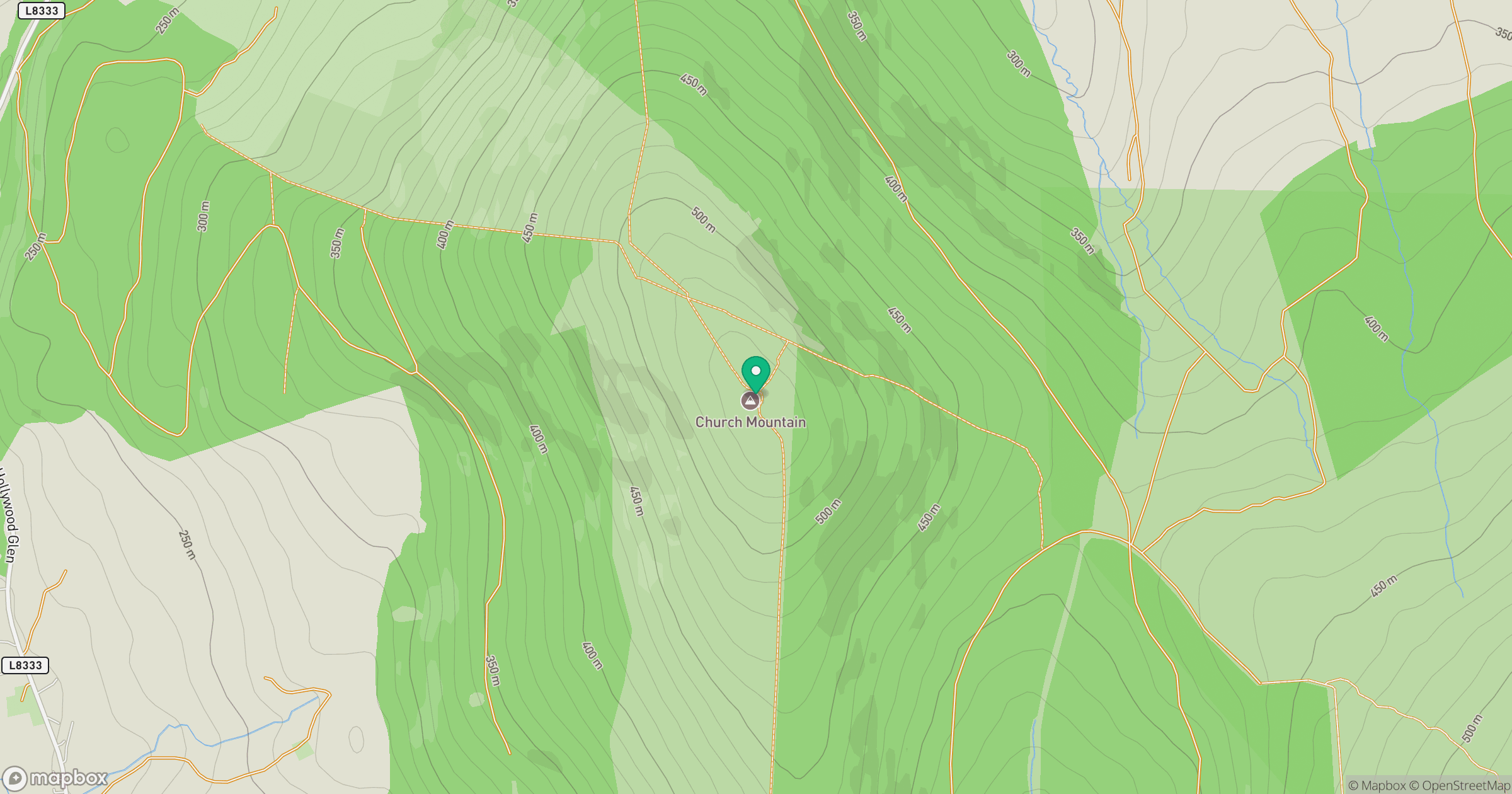
Grid reference: N948012
View on OpenStreetMapOpens a map in a new tab, centred on the hill.
Hills within 30 km
Straight-line distance, not a walking route or confirmation of access.
Lugnaquilla [Log na Coille]
925m
Mullaghcleevaun
847m
Slievecorragh [An Sliabh Corrach]
418m
Lobawn [Luban]
637m
Spinans Hill [Eadestown Hill] [Cnoc na Spionan]
408m
No comments yet. Be the first.