

Carnmoney Hill
Good walks are even better shared.
J3383 : Carnmoney Hill Triangulation Pillar
Rossographer Photo source
Overview
Carnmoney Hill rises to 231.1 m above Newtownabbey, County Antrim, Northern Ireland. Public trails explore the eastern woodland and viewpoints over Belfast Lough. The crest and western two-thirds are privately owned; the waymarked Hilltop Walk does not visit the separate trig-point summit.
Carnmoney Hill
Carnmoney Hill rises to 231.1 m above Newtownabbey in County Antrim, Northern Ireland. It is a Hump with 108 m of prominence. Its eastern woodland offers a choice of short walks and steeper climbs with views over Belfast Lough.
Public woodland and summit access
The Woodland Trust and council own most of the eastern third. The crest and western two-thirds are privately owned. DoBIH records the highest point beside a trig pillar at J332830; the official trail map shows that point west of the public Hilltop Walk. Keep to the waymarked woodland paths and obtain permission before venturing onto private summit land.
Walking routes
- Gentle Stroll: the red lower-ground loop starts and finishes at Knockenagh Avenue, passing the pond and grassland. The published walk is about 800 m and 15 minutes.
- Lower Woodland Walk: follow the yellow circuit from the woodland entrance to a Belfast Lough viewpoint and back. Allow about 45 minutes; there are steep sections.
- Hilltop woodland circuit: Belfast Hills Partnership suggests starting at Rathfern centre, walking by Doagh Road and Fernlea Lane, then following the blue public woodland trail back to Knockenagh Avenue. Very steep sections and the roadside approach make this the more demanding option. It does not visit the trig-point summit.
Getting there
Use the Knockenagh Avenue entrance beside Rathfern centre and its free roadside lay-by. A small alternative car park serves the Dunanney Lane entrance off O'Neill Road. Metro buses serve the Whiteabbey Hospital/Doagh Road approach; check the Translink journey planner for current services and include the uphill walk to the entrance.
The community centre has toilets, including accessible facilities, when it is open. A play area is beside the main entrance. Lower landscaped paths are distinct from the steep hill trails.
Terrain and safety
Expect woodland paths, grassy slopes, steps and uneven ground. Rain makes steep paths more slippery. Wear grippy footwear, follow current signs and take care beside traffic on the Fernlea circuit's road section. Do not cross fences or continue beyond the signed public paths to reach the summit.
Landscape and history
Ancient woodland, newer planting, grassland and wetland support varied wildlife; bluebells and primroses brighten the woods in spring. Carnmoney has an igneous origin, with volcanic rocks above limestone-bearing slopes. The Geological Survey identifies remnants of an ancient volcanic vent here.
The hill preserves traces of old farms, lime working and earlier settlement. Lilian Bland tested her Mayfly aircraft here in 1910. Belfast Hills Partnership translates the Irish name Carn Monaidh as 'cairn of the hill'.
Explore routes near Carnmoney Hill
Walks starting near this hill. Open a route to check its map, distance and full itinerary.
Belfast street-art walk
View route
Belfast street-art walk
View route
Lagan Towpath: Shaw's Bridge to Drumbeg Footbridge
View route
Drumbeg to Hilden Bridge: Lagan Towpath, Lambeg and Canal Locks
View route
Route planning notes
These notes describe possible approaches. Check a route's map and access information when planning your walk.
Gentle Stroll: red lower-ground loop
From the Knockenagh Avenue entrance beside Rathfern centre, follow the red waymarkers around the pond and landscaped grassland, returning to the same entrance. This short walk stays at the foot of the woodland. The Woodland Trust describes about 800 m of pathway and a 15-minute stroll.
Lower Woodland Walk: yellow circuit
Start at the Knockenagh Avenue woodland entrance and follow the yellow-waymarked circuit through the ancient woodland to the Belfast Lough viewpoint, then return on the signed lower route to the entrance. Allow about 45 minutes for the walk. Some sections are steep; wear footwear with good grip.
Hilltop woodland circuit via Fernlea Lane
Start and finish at Rathfern centre on Knockenagh Avenue. Walk through the residential streets to Doagh Road, turn towards the countryside, then take Fernlea Park and Fernlea Lane into the woodland. Follow the signed blue Hilltop Walk through the public site and descend to the Knockenagh Avenue exit to return to Rathfern. This circuit has very steep sections and a roadside approach. Stay on the public trail: the separate 231.1 m trig-point summit is outside the published walking route.
Make a day of it, together
Find someone to share the walk with, or organise a day out along a route you like.
Photo Gallery
View all Photo could not load
J3383 : Carnmoney Hill Triangulation Pillar
Rossographer
 Photo could not load
J3383 : Flush Bracket, Carnmoney Hill Triangulation Pillar
Rossographer
 Photo could not load
J3383 : Carnmoney Hill Trig Point
Paul McVarnock
 Photo could not load
J3383 : Carnmoney Hill Trig Point
Paul McVarnock
Hill facts and local notes
Classifications
Elevation
231m
758 ft
Prominence
108m
Coordinates
54.6779, -5.9354
J332830
OS Map
15
At the Summit
DoBIH records the highest ground beside a trig point at J332830, 231.1 m. The official walking map places this summit west of the public Hilltop Walk. The crest is privately owned; stay on the public trails unless you have landowner permission.
Terrain & Geology
Carnmoney is part of Antrim’s volcanic landscape, with an igneous cap and limestone-bearing slopes. The Geological Survey of Northern Ireland identifies agglomerate at Carnmoney as remnants of a volcanic vent that was later filled with magma.
Views & Scenery
Public woodland viewpoints overlook Belfast and Belfast Lough, with wider clear-weather views towards north Down, the Mournes, Slemish and the Antrim coast.
Best Seasons
Bluebells and primroses flower in the woodland in spring; autumn brings changing leaf colours.
History & Heritage
Name Origin
From the Irish Carn Monaidh, translated by Belfast Hills Partnership as “cairn of the hill”.
Historical Significance
Carnmoney Hill preserves raths, souterrains, old farm remains and limekilns. Lime was once produced for agriculture and building. Lilian Bland tested her Mayfly aircraft here in 1910. The Dunanney limekiln and Victorian farmstead were restored in 2015.
Getting There & Facilities
Parking
Free lay-by and roadside parking at the Knockenagh Avenue entrance beside Rathfern centre and the play area. Belfast Hills Partnership also lists a small free car park at Dunanney Lane off O’Neill Road. Keep entrances clear.
Public Transport
Metro buses serve the Whiteabbey Hospital/Doagh Road approach. From there, walk to Knockenagh Avenue and uphill to the woodland entrance. Use the Translink journey planner for current services and allow for the walk from the stop.
Nearby Facilities
There is a play area beside the main Knockenagh Avenue entrance. The community centre at the foot of the site provides toilets, including accessible facilities, while it is open. Lower landscaped paths offer a gentler option than the steep woodland routes.
Safety Information
Known Hazards
- The yellow woodland trail has steep sections; the blue Hilltop Walk has very steep inclines. Uneven paths and steps can become slippery after rain.
- The crest and western two-thirds are private land. The public Hilltop Walk does not give access to the separate trig-point summit; do not cross fences or leave the public trails without permission.
- The Fernlea Lane circuit includes residential roads and Doagh Road. Use pavements and take care at crossings.
Seasonal Hazards
Rain increases the slipping risk on steep woodland paths and grassy sections.
General Safety Tips
- Check weather conditions before setting out
- Carry appropriate clothing and equipment
- Let someone know your planned route
- Take a map, compass, and GPS device
- Carry emergency supplies: food, water, first aid kit, torch
Hills
Some common questions about the hills answered
Are there group walks up Carnmoney Hill?
Many walkers use Walkmates to join or organise walks with others. You can check for group walks around Carnmoney Hill through the maps
Are there other walkers around Carnmoney Hill?
Activity varies by location and time, but Walkmates lets you see whether others have shared walks or shown interest in this area. Find other people through the walking friends search walking friends for Carnmoney Hill search or of course create your own walk for Carnmoney Hill
Can I organise a walk to Carnmoney Hill?
Yes. If there aren’t any walks listed already, you can create a walk and make it available for others to join.
If you're signed up to Walkmates, you can create a walk to Carnmoney Hill.
How do I find a walk up this hill?
There are often multiple ways to walk this hill, depending on experience and route preference. Walkmates helps you explore walks and routes that others have shared.
Can I suggest a new route up Carnmoney Hill?
Yes. You can suggest or create routes to share with others. Walkmates focuses on the social side of walking, so routes are used to help people organise walks and explore areas together, rather than as detailed navigation tools or route libraries.
Other uses really appreciate knowledgeable walkers sharing their routes. Share your favourite route to Carnmoney Hill here
The is an error or something incorrect about this hill. How do I let you know?
We always strive to keep the information on Walkmates as accurate as possible. If you find an error, please let us know through the contact form and we'll aim to correct it as quickly as possible
Community Discussion
Comments
Location
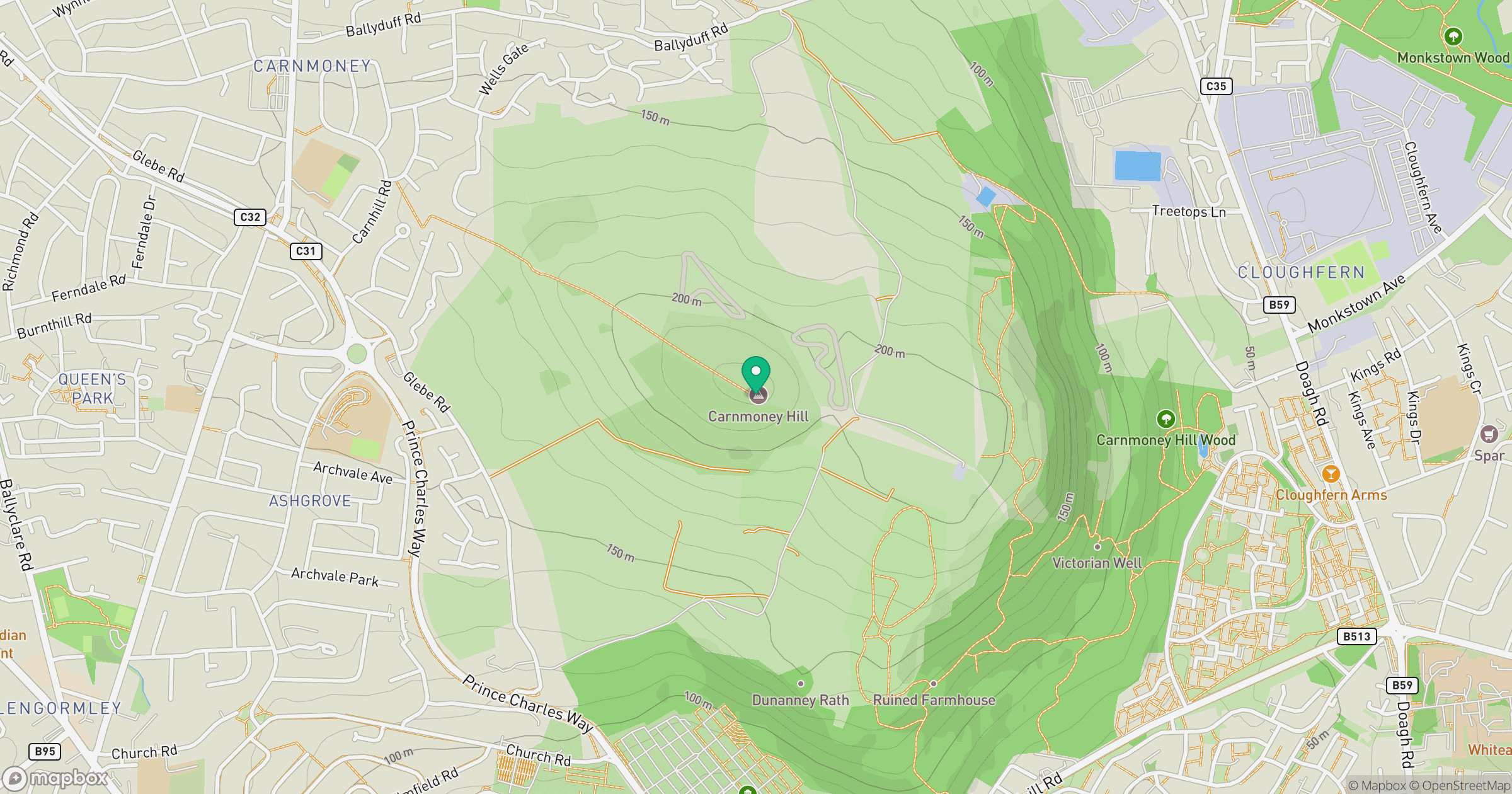
Grid reference: J332830
View on OpenStreetMapOpens a map in a new tab, centred on the hill.
No comments yet. Be the first.