

Divis
Good walks are even better shared.
J2875 : Divis Mountain from Divis Lodge
Eric Jones Photo source
Overview
Divis rises to 478 m above Belfast in Northern Ireland and is the highest point in the Belfast Hills. Its challenging Summit Trail climbs through open upland ground to the summit area. The neighbouring Black Mountain Ridge Trail is a separate route and does not reach Divis summit.
Divis: the highest of the Belfast Hills
Divis rises to 478 m above Belfast in Northern Ireland. It is a Marilyn, with 380 m of prominence, and forms part of the Belfast Hills’ open upland landscape.
Reaching the summit
When checked on 17 October 2026, Belfast Hills Partnership warned that the full Summit Trail circuit was unavailable during improvement works. Check the current notices and trailhead signs before setting out; no complete temporary summit itinerary or replacement distance has been established here.
The normal National Trust Summit Trail is a challenging 4.8 km circuit from Divis Barn (J272744), with a published walking time of 50–90 minutes. It normally follows Tipperary Road, climbs the steep stone path and returns along the tarmac road. These are the standard circuit's figures and directions, not a confirmed route during the works. The lower-car-park approach is additional.
The separate Ridge Trail visits Black Mountain rather than Divis summit. Belfast Hills Partnership also reports a temporary boardwalk closure with no through passage. Follow the signed turnaround instruction; do not use the normal circular itinerary while that closure applies. The Heath Trail circles the northern slopes. None of these trails' distances supplies a combined Divis ascent total.
Summit and surroundings
A trig pillar and fenced installation are landmarks in the summit area. The hill database identifies the highest ground outside the fence, about 8 m west of its north-west corner, rather than at the pillar itself.
Clear conditions offer views over Belfast and Belfast Lough, with Lough Neagh and the Mourne Mountains also visible. Divis is part of the basalt landscape of the Belfast Hills, formed by ancient lava flows above older sedimentary rocks.
Terrain and safety
Expect rough stone paths, steps and exposed heathland, with blanket bog away from the constructed routes. Wet surfaces need care. Take sturdy footwear, warm and waterproof layers, and navigation equipment. Strong winds, low cloud, snow or ice can make this short hill walk more demanding; allow for daylight and your group’s pace.
Keep to designated paths, give livestock plenty of space and keep dogs on a lead. Respect temporary closures during the improvement works.
Parking and facilities
The lower National Trust car park is on Divis Road, Hannahstown, reached from Upper Springfield Road. Parking is limited; avoid verges and do not obstruct residents or emergency access.
When checked on 16 October 2026, the National Trust visitor page listed the upper car park and Barn Café as closed during improvement works, with limited toilets available. Check current National Trust visitor information before travelling. Bring food and water rather than relying on refreshments being available.
Check current Translink services and onward travel arrangements. Do not assume a bus reaches the trailhead: the National Trust warns that the approach roads have long sections without footways.
Name and history
Divis is an anglicised form of Irish Dubhais, commonly translated as black ridge or black peak. The National Trust acquired Divis in 2004 following its military use. The wider landscape contains cairns, stone enclosures and remains of former farms.
Explore routes near Divis
Walks starting near this hill. Open a route to check its map, distance and full itinerary.
Belfast street-art walk
View route
Belfast street-art walk
View route
Lagan Towpath: Shaw's Bridge to Drumbeg Footbridge
View route
Drumbeg to Hilden Bridge: Lagan Towpath, Lambeg and Canal Locks
View route
Route planning notes
These notes describe possible approaches. Check a route's map and access information when planning your walk.
Divis Summit Trail (circuit temporarily unavailable)
When checked on 17 October 2026, Belfast Hills Partnership warned that the full Summit Trail circuit was unavailable during improvement works. The normal National Trust route is a challenging 4.8 km circuit from Divis Barn (J272744), with a published 50–90-minute allowance; those figures do not describe a confirmed works diversion. Follow current trailhead signs and check the official notices before setting out. The approach from the lower car park is additional.
Make a day of it, together
Find someone to share the walk with, or organise a day out along a route you like.
Photo Gallery
View all Photo could not load
J2875 : Divis Mountain from Divis Lodge
Eric Jones
 Photo could not load
J2875 : Divis Triangulation Pillar
Rossographer
 Photo could not load
J2875 : Flush Bracket, Divis Triangulation Pillar
Rossographer
 Photo could not load
J2875 : Spider, Divis Triangulation Pillar
Rossographer
 Photo could not load
J2875 : Salute the Mountain Men Memorial Stone
thejackrustles
 Photo could not load
J2875 : Divis Trig Point Flush Bracket 3211
thejackrustles
 Photo could not load
J2875 : The summit cairn on Divis
David Purchase
 Photo could not load
J2875 : The Divis Primary Triangulation Point
David Purchase
 Photo could not load
J2875 : 1825 Primary Triangulation Plaque, Divis
Rossographer

J2875 : Summit of Divis
Rossographer
Hill facts and local notes
Classifications
Elevation
478m
1,568 ft
Prominence
380m
Coordinates
54.6113, -6.0185
J280754
OS Map
15
At the Summit
A trig pillar and fenced installation stand in the summit area. The hill database places the highest ground outside the fence, about 8 m west of its north-west corner; the trig pillar is not the precise recorded high point.
Terrain & Geology
Divis belongs to the basalt landscape of the Belfast Hills. Ancient lava flows formed the hard basalt cap above older sedimentary rocks, including limestone.
Views & Scenery
In clear conditions the summit area offers views over Belfast and Belfast Lough, with Lough Neagh and the Mourne Mountains also visible.
History & Heritage
Name Origin
Divis is an anglicised form of Irish Dubhais, commonly translated as black ridge or black peak.
Historical Significance
The National Trust acquired Divis in 2004 after its military use. The wider landscape includes prehistoric cairns, stone enclosures and remains of former farms.
Getting There & Facilities
Parking
Use the National Trust lower car park on Divis Road, Hannahstown, off Upper Springfield Road. Spaces are limited. When checked on 16 October 2026, the Trust listed the upper car park as closed for improvement works. Check current notices before travel and do not park on verges or obstruct local access. The published Summit Trail starts at the Barn, so walking from this lower car park adds an approach.
Public Transport
Check current Translink services and onward travel arrangements. Do not assume a bus reaches the trailhead: the National Trust warns that approach roads include long sections without footways. Arrange a safe onward connection rather than relying on a roadside walk.
Nearby Facilities
Improvement works affect the visitor hub. When checked on 16 October 2026, the National Trust listed the Barn Café as closed and only limited toilets available. Bring food and water, and check current facilities and opening times before visiting.
Safety Information
Known Hazards
- Steep stone paths, steps and wet ground require care. Wear sturdy footwear and take warm and waterproof layers.
- This is exposed upland terrain. Low cloud and strong winds can make navigation and progress more difficult.
- Stay on designated paths, follow temporary closures and diversions, and keep dogs on a lead. Give cattle and calves plenty of space.
Seasonal Hazards
Snow and ice can make the steep paths and tarmac descent slippery. Short winter days and poor visibility require extra care with timing and navigation; choose a lower walk if conditions exceed your experience.
General Safety Tips
- Check weather conditions before setting out
- Carry appropriate clothing and equipment
- Let someone know your planned route
- Take a map, compass, and GPS device
- Carry emergency supplies: food, water, first aid kit, torch
Hills
Some common questions about the hills answered
Are there group walks up Divis?
Many walkers use Walkmates to join or organise walks with others. You can check for group walks around Divis through the maps
Are there other walkers around Divis?
Activity varies by location and time, but Walkmates lets you see whether others have shared walks or shown interest in this area. Find other people through the walking friends search walking friends for Divis search or of course create your own walk for Divis
Can I organise a walk to Divis?
Yes. If there aren’t any walks listed already, you can create a walk and make it available for others to join.
If you're signed up to Walkmates, you can create a walk to Divis.
How do I find a walk up this hill?
There are often multiple ways to walk this hill, depending on experience and route preference. Walkmates helps you explore walks and routes that others have shared.
Can I suggest a new route up Divis?
Yes. You can suggest or create routes to share with others. Walkmates focuses on the social side of walking, so routes are used to help people organise walks and explore areas together, rather than as detailed navigation tools or route libraries.
Other uses really appreciate knowledgeable walkers sharing their routes. Share your favourite route to Divis here
The is an error or something incorrect about this hill. How do I let you know?
We always strive to keep the information on Walkmates as accurate as possible. If you find an error, please let us know through the contact form and we'll aim to correct it as quickly as possible
Community Discussion
Comments
Location
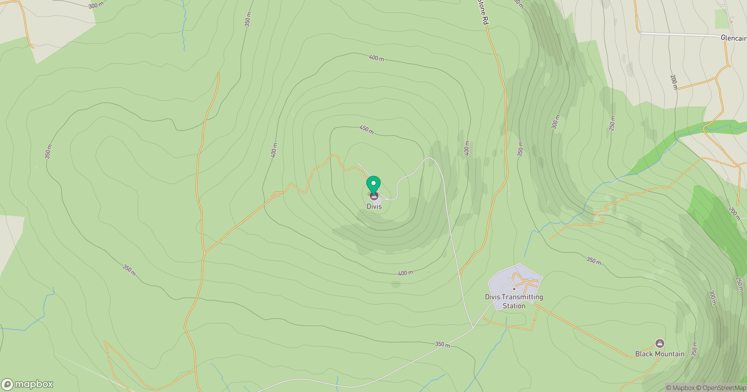
Grid reference: J280754
View on OpenStreetMapOpens a map in a new tab, centred on the hill.
Nearby Hills
Slieve Bearnagh
739m
Slieve Commedagh
767m
Slieve Donard
850m
Slievelamagan
702m
Slieve Binnian
746m
No comments yet. Be the first.