

Braigh na h-Eaglaise
Good walks are even better shared.
ND0622 : Braigh na h-Eaglaise
Peter Standing Photo source
Explore routes near Braigh na h-Eaglaise
Walks starting near this hill. Open a route to check its map, distance and full itinerary.
Loch Migdale from Torroy: Spinningdale pinewood and loch shore walk
View route
Ben Klibreck
View route
Culbin Forest: Hill 99, Gravel Pit Ponds and Dragonfly Pool
View route
Route planning notes
These notes describe possible approaches. Check a route's map and access information when planning your walk.
Moy's Farm Trail
A moderately challenging ascent starting from Moy's Farm. This route offers a blend of forestry and open hillside, ensuring a delightful variety of scenery as you make your way to the summit.
Make a day of it, together
Find someone to share the walk with, or organise a day out along a route you like.
Photo Gallery
View all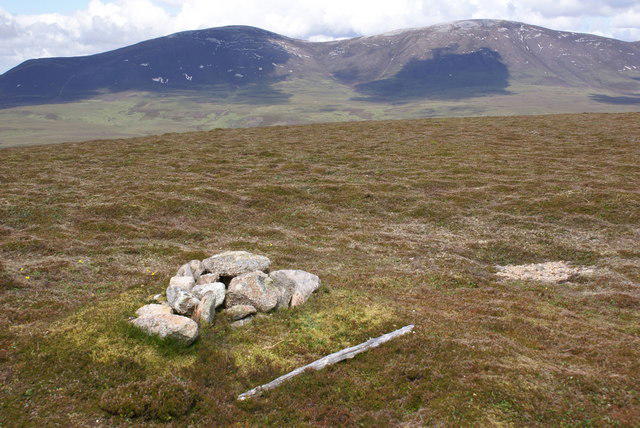 Photo could not load
ND0622 : Braigh na h-Eaglaise
Peter Standing
Hill facts and local notes
Classifications
Elevation
424m
1,390 ft
Prominence
185m
Coordinates
58.1777, -3.5917
ND064220
OS Map
17
Explorer: 444E
At the Summit
The summit is marked by a prominent cairn, which can serve as an excellent photo opportunity. On a clear day, a trig point lies nearby, offering a perfect perch to enjoy a well-deserved snack.
Terrain & Geology
The mountain is predominantly composed of schist and gneiss, featuring classic Highland geology that has been shaped by both ancient tectonic movements and glacial erosion. The striations visible in the rocks testify to this tumultuous past.
Views & Scenery
From the summit, you can enjoy sweeping views of the surrounding glens and nearby peaks, including the impressive Ben Nevis to the southwest. The sights are enough to make anyone a poet—or at least willing to try their hand at it.
History & Heritage
Name Origin
The name 'Braigh na h-Eaglaise' translates to 'brae of the church', indicating historical ties to a place of worship in the area. The higher ground likely offered a viewpoint for the faithful.
Historical Significance
Historically, the area has been significant for both pastoral farming and as a lookout point during various conflicts, providing strategic views of the surrounding terrain.
Getting There & Facilities
Parking
Parking available at the end of the single-track road leading to Moy's Farm. Spaces can be limited, especially in peak season, so it's advisable to arrive early.
Public Transport
Limited public transport options are available; however, several buses operate from Inverness with stops in nearby small villages. It's best to check local timetables.
Nearby Facilities
Cafes and toilets are best found in Inverness. No facilities are available on or near the mountain; it's advisable to bring sufficient supplies and snacks for the journey.
Safety Information
Known Hazards
- Be mindful of sudden weather changes, as conditions can turn quickly in the Highlands. Watch for loose stones on rocky paths and be cautious in boggy areas that may lead to unexpected wet socks.
General Safety Tips
- Check weather conditions before setting out
- Carry appropriate clothing and equipment
- Let someone know your planned route
- Take a map, compass, and GPS device
- Carry emergency supplies: food, water, first aid kit, torch
Hills
Some common questions about the hills answered
Are there group walks up Braigh na h-Eaglaise?
Many walkers use Walkmates to join or organise walks with others. You can check for group walks around Braigh na h-Eaglaise through the maps
Are there other walkers around Braigh na h-Eaglaise?
Activity varies by location and time, but Walkmates lets you see whether others have shared walks or shown interest in this area. Find other people through the walking friends search walking friends for Braigh na h-Eaglaise search or of course create your own walk for Braigh na h-Eaglaise
Can I organise a walk to Braigh na h-Eaglaise?
Yes. If there aren’t any walks listed already, you can create a walk and make it available for others to join.
If you're signed up to Walkmates, you can create a walk to Braigh na h-Eaglaise.
How do I find a walk up this hill?
There are often multiple ways to walk this hill, depending on experience and route preference. Walkmates helps you explore walks and routes that others have shared.
Can I suggest a new route up Braigh na h-Eaglaise?
Yes. You can suggest or create routes to share with others. Walkmates focuses on the social side of walking, so routes are used to help people organise walks and explore areas together, rather than as detailed navigation tools or route libraries.
Other uses really appreciate knowledgeable walkers sharing their routes. Share your favourite route to Braigh na h-Eaglaise here
The is an error or something incorrect about this hill. How do I let you know?
We always strive to keep the information on Walkmates as accurate as possible. If you find an error, please let us know through the contact form and we'll aim to correct it as quickly as possible
Community Discussion
Comments
Location
View the hill's mapped position and surrounding paths.
Grid reference: ND064220
View on OpenStreetMapOpens a map in a new tab, centred on the hill.
No comments yet. Be the first.