
Beinn Dubhcharaidh
Good walks are even better shared.
Overview
Beinn Dubhcharaidh
Overview
Beinn Dubhcharaidh is a splendid Munro nestled in the Scottish Highlands, standing at 779 meters tall. This mountain is not just about height; its dramatic ridges and stunning vistas make it an enticing challenge for outdoor enthusiasts.
Geology
The rocky terrain primarily consists of granite, a robust material offering stability beneath your feet. If you’re inclined to study the landscape, you’ll notice the evidence of glacial activity, with smooth valleys carved long ago, just waiting for you to tread upon.
Routes
The primary route to the summit is the North East Ridge. This moderate hike spans approximately 10 km, typically taking around four hours. It’s the kind of route that slips in a few scenic views while giving your calves a proper workout. Just be sure to pack some snacks because nobody likes a hangry hiker.
Summit Features
Reaching the top, you'll find a traditional stone cairn, an ideal location for a celebratory snack or simply to bask in the glory of achieving Munro status. Not too far from the cairn is a trig point, perfect for those 'I made it!' selfies.
Terrain Type
Expect a mix of rocky paths and grassy patches. It’s a bit of a tussle in places, but hey, it keeps things interesting, right?
Views
The scenery from Beinn Dubhcharaidh is nothing short of spectacular. On a clear day, you can spot iconic locations such as Ben Nevis and Loch Ness. For the best viewing experience, plan your hike in spring or autumn when the weather behaves itself – well, as much as Scottish weather can!
Hazards
Watch your step on the loose rocky bits, and be prepared for changing weather conditions. It’s not uncommon to be bathed in sunshine one moment and then caught in a shower the next. Layers are your best friend here!
Nearby Summits
Feeling adventurous? Consider tackling nearby peaks like Beinn a'Chaorainn and Beinn Mhanach for more panoramic views and a thorough exploration of the region.
Access
You’ll find the nearest parking at NH 579 199. Get there early to snag a spot, especially during the peak season. If you prefer public transport, there's a bus service running between Fort William and Inverness, stopping at nearby villages. The closest town is Fort William, where you'll find a wealth of resources before and after your adventure.
Facilities
After your hike, head back to Fort William. This lively town boasts plenty of cafes and restaurants, perfect for refuelling after a day on the hill.
History
The name Beinn Dubhcharaidh translates to 'Mountain of the dark place' in Gaelic. It's steeped in local folklore and was once considered prime hunting grounds for ancient clans.
In conclusion, Beinn Dubhcharaidh is a must-visit for anyone seeking a quintessential Scottish adventure. Bring your sense of humour, a well-packed lunch, and embrace the unpredictability of the great outdoors.
Happy hiking!
Explore routes near Beinn Dubhcharaidh
Public walks starting within 80 km of this hill. Nearby does not mean a route reaches the summit; check its map and access before setting out.
Great Glen Way low route: Fort Augustus to Invermoriston Old Bridge
View route
Fort Augustus to Kytra Lock: Caledonian Canal Towpath
View route
Inverness: River Ness and Caledonian Canal circuit
View route
Glen Affric: Coire Loch Woodland Trail
View route
Route planning notes
These notes describe possible approaches, not verified navigable routes or permission to cross land. Check current paths, local access rules and conditions before setting out.
North East Ridge
This route ascends the North East ridge proving to be both scenic and satisfying, ideal for those who fancy a bit of elevation with their views.
Make a day of it, together
Find someone to share the walk with, or organise a day out along a route you like.
Hill facts and local notes
Classifications
Elevation
690m
2,264 ft
Prominence
131m
Coordinates
57.2483, -4.3402
NH589199
OS Map
35
Explorer: 417
At the Summit
At the summit, hikers will be greeted by a majestic cairn, standing proudly against the sky. A trig point sits nearby, offering a prime spot for that all-important selfie.
Terrain & Geology
Beinn Dubhcharaidh is primarily composed of granite, providing a solid and reliable footing - not too wobbly for your average hiker. The mountain's rugged slopes offer glimpses of glacial scouring, telling tales from the last Ice Age.
Views & Scenery
On a clear day, the summits of Ben Nevis and the sprawling Loch Ness can be seen in the distance, as well as the stunning valleys of the Great Glen.
History & Heritage
Name Origin
The name Beinn Dubhcharaidh comes from Gaelic, meaning 'Mountain of the dark place', a clever nod to its sometimes brooding appearance.
Historical Significance
Historically, this mountain is part of ancient hunting grounds and has significance in local folklore, with tales of mythical creatures prowling its slopes.
Getting There & Facilities
Check current local access restrictions, parking rules and transport timetables before travelling. These notes do not confirm public access to the summit.
Parking
There is a small parking area at NH 579 199, best to arrive early on weekends as it fills up quickly.
Public Transport
Buses from Fort William to Inverness stop in nearby villages; check the local timetable for the latest updates.
Nearby Facilities
Fort William offers plenty of facilities including cafes, restaurants, and public toilets. Perfect for a post-hike reward!
Safety Information
Known Hazards
- Loose rocks in some sections may present a tripping hazard. Weather can change rapidly, so be prepared for anything from sun to rain and a cheeky wind.
General Safety Tips
- Check weather conditions before setting out
- Carry appropriate clothing and equipment
- Let someone know your planned route
- Take a map, compass, and GPS device
- Carry emergency supplies: food, water, first aid kit, torch
Hills
Some common questions about the hills answered
Are there group walks up Beinn Dubhcharaidh?
Many walkers use Walkmates to join or organise walks with others. You can check for group walks around Beinn Dubhcharaidh through the maps
Are there other walkers around Beinn Dubhcharaidh?
Activity varies by location and time, but Walkmates lets you see whether others have shared walks or shown interest in this area. Find other people through the walking friends search walking friends for Beinn Dubhcharaidh search or of course create your own walk for Beinn Dubhcharaidh
Can I organise a walk to Beinn Dubhcharaidh?
Yes. If there aren’t any walks listed already, you can create a walk and make it available for others to join.
If you're signed up to Walkmates, you can create a walk to Beinn Dubhcharaidh.
How do I find a walk up this hill?
There are often multiple ways to walk this hill, depending on experience and route preference. Walkmates helps you explore walks and routes that others have shared.
Can I suggest a new route up Beinn Dubhcharaidh?
Yes. You can suggest or create routes to share with others. Walkmates focuses on the social side of walking, so routes are used to help people organise walks and explore areas together, rather than as detailed navigation tools or route libraries.
Other uses really appreciate knowledgeable walkers sharing their routes. Share your favourite route to Beinn Dubhcharaidh here
The is an error or something incorrect about this hill. How do I let you know?
We always strive to keep the information on Walkmates as accurate as possible. If you find an error, please let us know through the contact form and we'll aim to correct it as quickly as possible
Community Discussion
Comments
Location
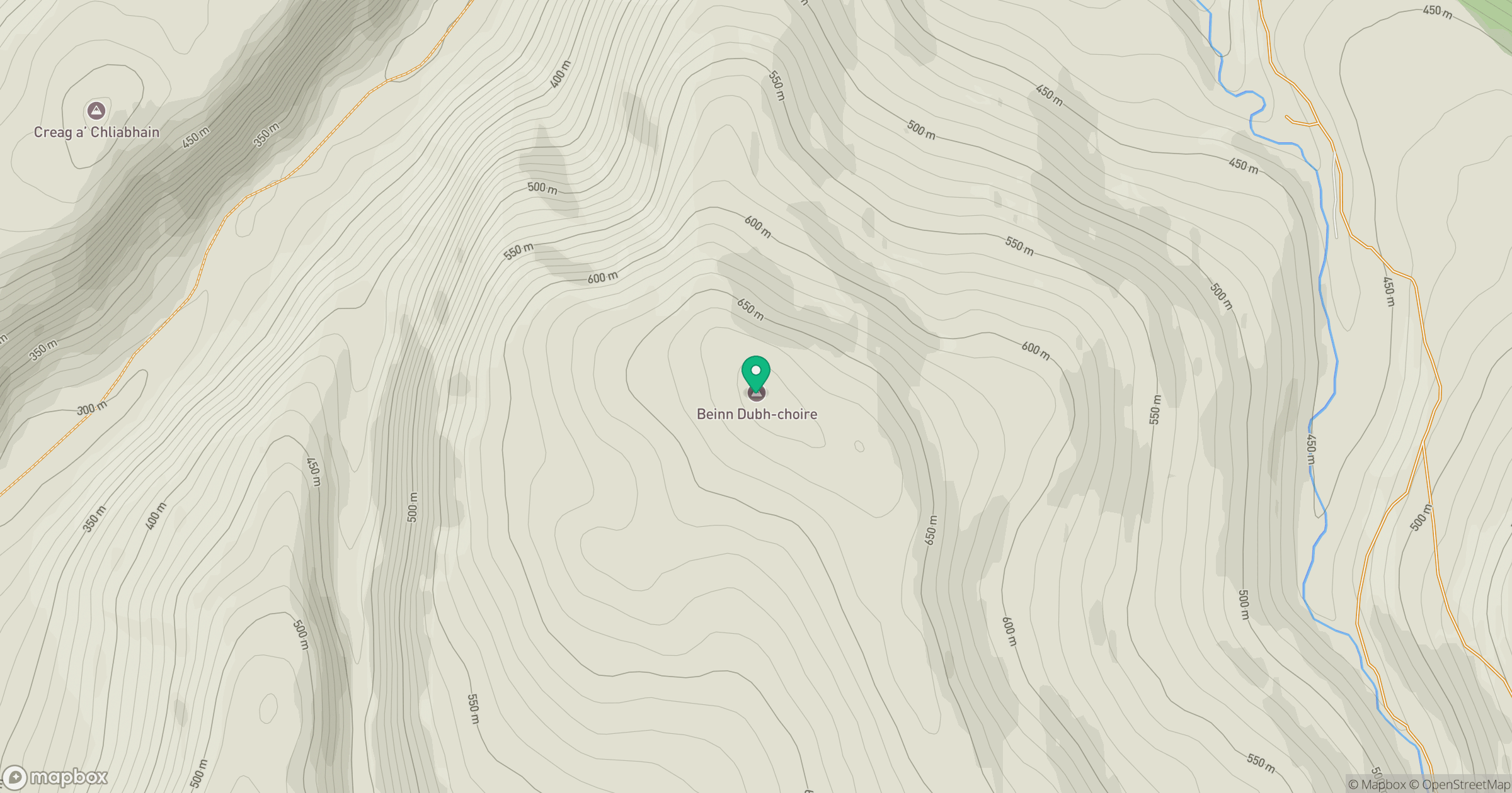
Grid reference: NH589199
View on OpenStreetMapOpens a map in a new tab, centred on the hill.
Hills within 30 km
Straight-line distance, not a walking route or confirmation of access.
Beinn Mheadhoin
541m
Binnein Mor
550m
Creag a' Chliabhain
519m
Beinn Mheadhoin
555m
Carn na Saobhaidhe
811m
No comments yet. Be the first.