Using a GPX file on a walk: checks before you follow it
Check a GPX download, inspect the imported route, test offline mapping and verify access before you follow the line on a walk.
Read guidePractical UK walking advice on map reading, difficulty grades, wet weather, daylight, footwear and countryside access.
Check a GPX download, inspect the imported route, test offline mapping and verify access before you follow the line on a walk.
Read guide
Understand walking difficulty labels, compare different grading systems and separate terrain, pace and access needs before choosing an outing.
Read guide
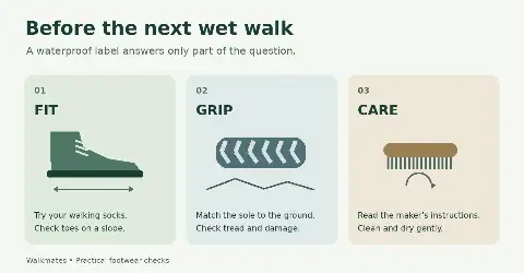
How to check walking footwear for a comfortable fit, suitable grip and wet-weather use, with practical care advice and clear winter limits.
Read guidePlan a daylight walk by checking local sunset, budgeting the whole outing and choosing a finish time, with a worked example and practical decision points.
Read guideA useful day-walk packing list, with advice on keeping kit dry, checking footwear and carrying what you need when the day takes longer than planned.
Read guideLook beyond the mileage. A practical guide to choosing a walk that suits your pace, the terrain, the weather and the time you have.
Read guideRead a walking map with more confidence: check scale, contours, access and junctions, then turn the route line into a practical plan.
Read guideWhat to check before entering a field with cattle, how to manage a dog around livestock, and why gates should be left as you find them.
Read guideHow to plan a wet-weather walk: read the forecast, choose suitable ground, keep spare clothes dry and decide when it is time to shorten the route.
Read guideNecessary storage keeps Walkmates working. With your permission, Google Analytics, Mixpanel and Simple Analytics help us understand how the site is used. Optional analytics stay off until you choose.