

South Cathkin Hill
Good walks are even better shared.
NS6257 : Hill Field Trig Point Flush Bracket S3609
thejackrustles Photo source
Overview
South Cathkin Hill
Nestled within the stunning Southern Uplands of Scotland, South Cathkin Hill stands proudly at an elevation of 493 meters, offering a delightful escape for hikers and outdoor enthusiasts alike.
Geology
The hill is an amalgamation of fascinating geology, primarily volcanic rock—mostly basalt. This results in a sharp, rugged terrain that is as inviting as it is challenging. The surrounding habitat is teeming with life, making it a haven for nature enthusiasts.
Routes
There are a couple of popular routes to reach the summit:
- Cathkin Braes Trail: This moderate 6.5 km route starts at the Cathkin Braes Country Park, winding through green pastures and patches of woodland. On a sunny day, it's truly a sight to behold!
- Eastside Path: For those feeling a bit more adventurous, this direct ascent takes you on a more challenging path of 4 km. It's steeper but rewards the intrepid with spectacular views, so don’t forget your camera!
Summit Features
Upon reaching the summit, you’ll be greeted by a distinguished trig point, a perfect landmark for your selfies, surrounded by intriguing rocky formations which will remind you of an amateur rock band (no, not that one!).
Terrain Type
Expect a mixture of grassy trails intertwined with rocky outcrops. It provides a stimulating walking experience and an opportunity for a little leg workout!
Views
The summit offers breathtaking views of the expansive Glasgow skyline, the Campsie Fells, and on clear days, glimpses of the Trossachs. For those seeking the best photographic opportunities, plan your trip in spring or autumn when nature dons its finest attire.
Hazards
Be aware that the paths can be steep and slippery, particularly after rain, and watch for sudden weather changes typical of these Scottish hills. Always best to be prepared—better safe than soggy, as they say!
Nearby Summits
If you're looking for additional adventure, consider a visit to nearby Cathkin Braes (337 meters), which also promises beautiful views and an enjoyable hiking experience.
Access
Parking is available at Cathkin Braes Country Park, which is well-equipped for visitors. Alternatively, public transport will drop you off at Castlemilk, followed by a pleasant stroll to the trails. The nearest town is Glasgow, where you can grab a coffee after your hike.
Facilities
While South Cathkin Hill itself may be devoid of facilities, you can find toilets and picnic spots at the Country Park. If you’re craving something more substantial after your hike, head back to Glasgow for a delightful meal.
History
The name Cathkin could have Gaelic origins, tied to 'a place of wild animals', and the mountain's significance in local culture can’t be overstated. It’s a cherished location for walkers and has a history steeped in outdoor activity.
So grab your boots, pack a snack, and prepare to bask in the stunning vistas that South Cathkin Hill has to offer. After all, a hike without a view is just a really long walk!
Explore routes near South Cathkin Hill
Walks starting near this hill. Open a route to check its map, distance and full itinerary.
Cambuslang Walk with Men Walking & Talking
View route
Motherwell: Strathclyde Loch full shoreline circuit
View route
Paisley Walk with Men Walking & Talking
View route
Kirkintilloch to Twechar Bridge: Forth and Clyde Canal Return
View route
Route planning notes
These notes describe possible approaches. Check a route's map and access information when planning your walk.
Cathkin Braes Trail
A scenic route that begins at Cathkin Braes Country Park and winds gently upwards through grassy paths and woodland before reaching the summit.
Eastside Path
A more direct ascent from the east side, this route is steep in places but rewards hikers with stunning views.
Make a day of it, together
Find someone to share the walk with, or organise a day out along a route you like.
Photo Gallery
View all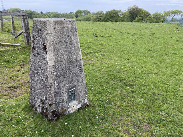 Photo could not load
NS6257 : Hill Field Trig Point Flush Bracket S3609
thejackrustles
Hill facts and local notes
Classifications
Elevation
227m
745 ft
Prominence
72m
Coordinates
55.7907, -4.1908
NS627574
OS Map
64
Explorer: 342
At the Summit
The summit features a prominent trig point which provides a great photo opportunity, alongside scattered rocks that make for an adventurous topography.
Terrain & Geology
The hill is primarily composed of volcanic rock, notably basalt, which contributes to its rugged landscape and sharp features. The area surrounding is rich in flora and fauna, offering a vibrant ecosystem.
Views & Scenery
From the summit, you can see stunning views of the nearby Glasgow skyline, the Campsie Fells, and even the wilds of the Trossachs on a clear day.
History & Heritage
Name Origin
The name 'Cathkin' is derived from Gaelic origins, though its exact meaning is unclear, possibly relating to 'a place of wild animals'.
Historical Significance
South Cathkin Hill has been a popular spot for local walkers and a site for various outdoor activities, particularly cycling and bird watching.
Getting There & Facilities
Parking
The nearest parking is at Cathkin Braes Country Park, which has ample space and offers facilities such as picnic areas.
Public Transport
The area is accessible via public transport; take the bus to Castlemilk and then it's a short walk to the trailhead.
Nearby Facilities
There are limited facilities on the hill itself but Cathkin Braes Country Park has toilets and picnic areas. For more facilities, head back into Glasgow.
Safety Information
Known Hazards
- Steep paths that may be slippery in wet conditions; sudden weather changes common to the area.
General Safety Tips
- Check weather conditions before setting out
- Carry appropriate clothing and equipment
- Let someone know your planned route
- Take a map, compass, and GPS device
- Carry emergency supplies: food, water, first aid kit, torch
Hills
Some common questions about the hills answered
Are there group walks up South Cathkin Hill?
Many walkers use Walkmates to join or organise walks with others. You can check for group walks around South Cathkin Hill through the maps
Are there other walkers around South Cathkin Hill?
Activity varies by location and time, but Walkmates lets you see whether others have shared walks or shown interest in this area. Find other people through the walking friends search walking friends for South Cathkin Hill search or of course create your own walk for South Cathkin Hill
Can I organise a walk to South Cathkin Hill?
Yes. If there aren’t any walks listed already, you can create a walk and make it available for others to join.
If you're signed up to Walkmates, you can create a walk to South Cathkin Hill.
How do I find a walk up this hill?
There are often multiple ways to walk this hill, depending on experience and route preference. Walkmates helps you explore walks and routes that others have shared.
Can I suggest a new route up South Cathkin Hill?
Yes. You can suggest or create routes to share with others. Walkmates focuses on the social side of walking, so routes are used to help people organise walks and explore areas together, rather than as detailed navigation tools or route libraries.
Other uses really appreciate knowledgeable walkers sharing their routes. Share your favourite route to South Cathkin Hill here
The is an error or something incorrect about this hill. How do I let you know?
We always strive to keep the information on Walkmates as accurate as possible. If you find an error, please let us know through the contact form and we'll aim to correct it as quickly as possible
Community Discussion
Comments
Location
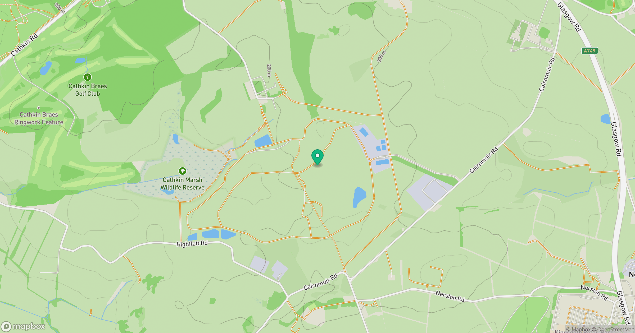
Grid reference: NS627574
View on OpenStreetMapOpens a map in a new tab, centred on the hill.


No comments yet. Be the first.