

Pole Hill
Good walks are even better shared.
Overview
Pole Hill: A Hidden Gem in the Peak District
Nestled within the stunning landscapes of the Peak District, Pole Hill is a Marilyn standing proud at an elevation of 487 meters. With a prominence of 42 meters, this hill may not sound intimidating, but it offers a delightful challenge paired with breathtaking views.
Geology
Pole Hill is primarily comprised of gritstone, a rock that tells tales of time’s passage. Its layered composition has created striking topographies that not only attract hikers but also geologists keen to study this ancient landscape.
Routes
Pole Hill Circular Walk
Starting from the picturesque village of Hayfield, this moderate circular route spans approximately 7.5 km. Walkers can expect to traverse lovely woodlands and serene fields, culminating in a gratifying ascent to the summit of Pole Hill. Make sure to pack a snack; the views at the top are well worth the break!
Summit Features
At the summit, adventurers are greeted by a small but charming rock outcrop, along with a trig point proudly marking the hill's height. This is the ideal spot for a well-earned photo opportunity, so don’t forget your camera—it's a 'trig-tastic' view!
Terrain Type
The terrain offers a blend of grassy slopes peppered with rocky outcrops, making for an engaging trek. Be mindful of the steep sections, especially after a rainfall, as they can contribute to some rather cheeky slips and slides!
Views
Those who reach the summit will be rewarded with sweeping views of the surrounding Peak District, including the formidable Kinder Scout and the tranquil Derwent Valley. Spring and summer provide the clearest perspectives, while autumn's lush colours add an extra touch of magic to your visit.
Hazards
As with many outdoor pursuits, caution is key! Be wary of uneven ground and slippery rocks, particularly after wet weather. The Peak District is known for its unpredictable climate; always be prepared for a sudden squall!
Nearby Summits
For those eager to extend their adventure, nearby summits such as Kinder Scout (636 meters) and the charming Ladybower Reservoir (140 meters) await exploration. They make for great companions on a day of hillwalking!
Access
Getting to Pole Hill is a breezy affair. The nearest parking is available at Bowden Bridge car park, just a short walk from the trailhead. For those relying on public transport, various bus routes from Glossop and Hayfield conveniently drop you at the starting point. The village of Hayfield is the closest town, full of warmth and local charm following your hike.
Facilities
Post-hike, treat yourself at one of the cafes or pubs in Hayfield, where a pint or a steaming cup of tea awaits you. If nature calls, public toilets are accessible within the village to freshen up after your outdoor adventure.
History
The name 'Pole Hill' is derived from its striking pole-like appearance when viewed from certain angles. Legend has it that this hill served as a lookout point for sheep farmers of yore, blending history and nature into a single tale fit for sharing around a campfire.
Conclusion
In summary, Pole Hill might be a lesser-known treasure of the Peak District, but it offers a splendid escape into nature with thrills and tranquillity aplenty. Whether you are a seasoned hiker or a casual walker, do yourself a favour and discover this delightful hill. Pack your rucksack, lace up your boots, and enjoy the great outdoors!
Explore routes near Pole Hill
Public walks starting within 80 km of this hill. Nearby does not mean a route reaches the summit; check its map and access before setting out.
Club outing: Glen Ogle and Killin (coach departure)
View route
Unled club outing: Glenesk (coach departure)
View route
Unled club outing: Xmas Walk - Bankfoot - Dunkeld (coach departure)
View route
Unled club outing: Angus coastal walk (coach departure)
View route
Route planning notes
These notes describe possible approaches, not verified navigable routes or permission to cross land. Check current paths, local access rules and conditions before setting out.
Pole Hill Circular Walk
A scenic circular route that begins from the nearby village of Hayfield, taking you through lush woodlands and open fields before ascending to the summit of Pole Hill.
Make a day of it, together
Find someone to share the walk with, or organise a day out along a route you like.
Photo Gallery
View all Photo could not load
NO1925 : Rough grazing, Pole Hill
Richard Webb
 Photo could not load
NO1926 : View from Pole Hill
William Starkey
 Photo could not load
NO1926 : Trig point, Pole Hill
Becky Williamson
 Photo could not load
NO1926 : Summit, Pole Hill
Richard Webb
 Photo could not load
NO1926 : Pole Hill
Rude Health
 Photo could not load
NO1926 : Pole Hill Trig Pillar
Scott Cormie
Hill facts and local notes
Classifications
Elevation
288m
945 ft
Prominence
105m
Coordinates
56.4199, -3.3055
NO195260
OS Map
53 58
Explorer: 380W
At the Summit
The summit is characterised by a small rock outcrop which provides a perfect photo opportunity, alongside a trig point marking the height.
Terrain & Geology
Pole Hill is primarily composed of gritstone, a resilient rock type known for its layering and durability. The area's geological history has resulted in dramatic landscapes, providing an excellent study for rock enthusiasts.
Views & Scenery
From the summit, walkers can enjoy panoramic views of the surrounding Peak District, including the impressive Kinder Scout and the expansive Derwent Valley.
History & Heritage
Name Origin
The name 'Pole Hill' derives from its distinctive shape, resembling a pole when viewed from certain angles.
Historical Significance
Steeped in local folklore, it is believed that the hill was a lookout point for sheep farmers in times gone by.
Getting There & Facilities
Check current local access restrictions, parking rules and transport timetables before travelling. These notes do not confirm public access to the summit.
Parking
The nearest parking area is located at the Bowden Bridge car park, approximately 1.5 km from the start of the walk.
Public Transport
Regular bus services run from nearby towns like Glossop and Hayfield to the foot of the hill.
Nearby Facilities
The village of Hayfield offers several options for refreshments, including cafes and pubs. Public toilets are also available in the village.
Safety Information
Known Hazards
- Watch out for uneven ground and slippery rocks, especially after rain. Also, the area can be prone to sudden weather changes.
General Safety Tips
- Check weather conditions before setting out
- Carry appropriate clothing and equipment
- Let someone know your planned route
- Take a map, compass, and GPS device
- Carry emergency supplies: food, water, first aid kit, torch
Hills
Some common questions about the hills answered
Are there group walks up Pole Hill?
Many walkers use Walkmates to join or organise walks with others. You can check for group walks around Pole Hill through the maps
Are there other walkers around Pole Hill?
Activity varies by location and time, but Walkmates lets you see whether others have shared walks or shown interest in this area. Find other people through the walking friends search walking friends for Pole Hill search or of course create your own walk for Pole Hill
Can I organise a walk to Pole Hill?
Yes. If there aren’t any walks listed already, you can create a walk and make it available for others to join.
If you're signed up to Walkmates, you can create a walk to Pole Hill.
How do I find a walk up this hill?
There are often multiple ways to walk this hill, depending on experience and route preference. Walkmates helps you explore walks and routes that others have shared.
Can I suggest a new route up Pole Hill?
Yes. You can suggest or create routes to share with others. Walkmates focuses on the social side of walking, so routes are used to help people organise walks and explore areas together, rather than as detailed navigation tools or route libraries.
Other uses really appreciate knowledgeable walkers sharing their routes. Share your favourite route to Pole Hill here
The is an error or something incorrect about this hill. How do I let you know?
We always strive to keep the information on Walkmates as accurate as possible. If you find an error, please let us know through the contact form and we'll aim to correct it as quickly as possible
Community Discussion
Comments
Location
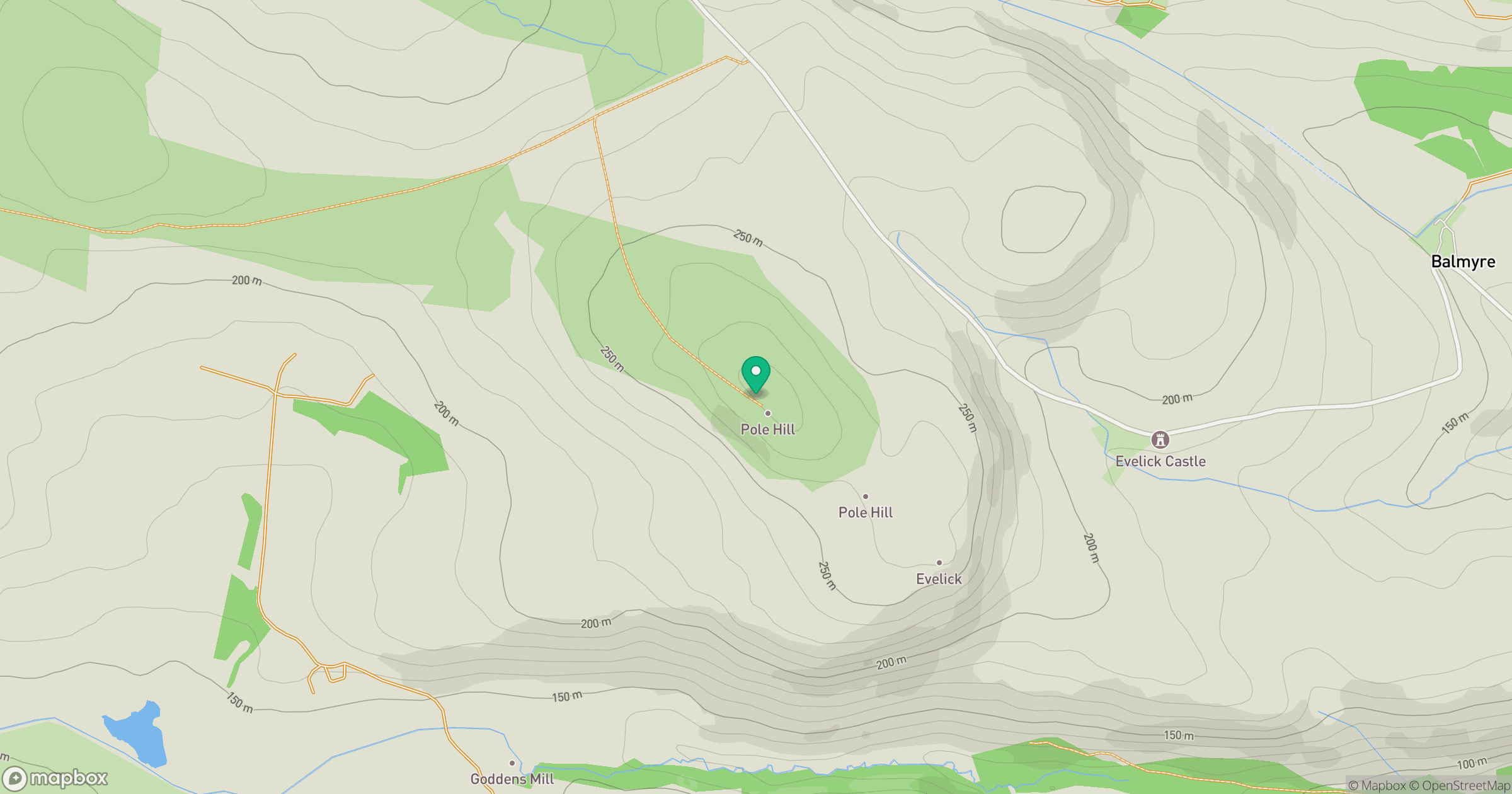
Grid reference: NO195260
View on OpenStreetMapOpens a map in a new tab, centred on the hill.
Hills within 30 km
Straight-line distance, not a walking route or confirmation of access.
King's Seat
377m
Lumbennie Hill
284m
Gask Hill
358m
Ormiston Hill [Black Cairn Hill]
236m
Moncreiffe Hill
223m
No comments yet. Be the first.