
Mucklety Hill
Good walks are even better shared.
Overview
Mucklety Hill: A Hidden Gem in the Scottish Highlands
Introduction
Nestled in the scenic landscape of the Scottish Highlands, Mucklety Hill stands proudly at 151 meters. While it may be modest in height compared to its towering neighbours, it offers hikers a unique blend of rich geological history and breathtaking views.
Geology
Mucklety Hill is primarily composed of ancient schists and phyllites, showcasing the metamorphic rock formations typical of this region. The remnants of ancient geological activities are evident in the rugged outcrops and the surrounding landscape, making this area a fascinating study for geology enthusiasts.
Routes
The popular Mucklety Hill Circular Route provides a delightful excursion starting from the charming village of Kippen. This moderate trail covers approximately 8.5 km and typically takes about 3.5 hours to complete, allowing for plenty of time to soak in the picturesque surroundings. Be prepared for a varied terrain, with both grassy paths and rocky sections that keep your hike interesting!
Summit Features
As you reach the summit, you'll be greeted by a distinctive trig point set amidst a rocky outcrop. It’s a perfect spot for a jubilant photo op and a chance to catch your breath!
Terrain Type
Expect a mixed terrain of grassy slopes, rocky features, and inevitable boggy patches (especially after a good downpour), so proper footwear is a must!
Views
From the heights of Mucklety, the panoramic views are simply stunning. On clear days, you can see the shimmering waters of Loch Lomond and the majestic peaks of the Trossachs National Park. The best seasons for viewing are late spring and early autumn, when the scenery is vibrant and the weather is relatively stable.
Hazards
While wandering through the Highlands is a joy, do keep an eye on the trail as it can be slippery after rain, and sudden weather changes are a hallmark of the region. Wildlife is abundant, so be prepared for potential animal encounters!
Nearby Summits
Mucklety Hill is surrounded by an array of other peaks, including Ben Ledi (878 meters) and Ben Venue (729 meters), both offering additional hiking opportunities for the adventurous.
Access
Getting to Mucklety Hill is quite straightforward. The nearest parking is in Kippen, where expect limited on-street options, so an early arrival is recommended to snag a spot. Public transport can be accessed via regular bus services from Stirling, but double-check the schedules!
Facilities
After your hike, consider stopping at Kippen for a refreshing drink and a bite to eat at the local café or pub. Basic toilet facilities are also available.
History
The name Mucklety is thought to come from the Gaelic word for pig, hinting at its pastoral history. Locally, it holds cultural significance, often appearing in folklore and tales passed down through generations.
Conclusion
Mucklety Hill may not be the highest peak in the Highlands, but it offers a captivating experience wrapped in natural beauty and local history. Whether you're looking for a leisurely hike, a spot for contemplation, or a chance to connect with the rugged landscape, Mucklety should be on your list.
Happy hiking!
Explore routes near Mucklety Hill
Public walks starting within 80 km of this hill. Nearby does not mean a route reaches the summit; check its map and access before setting out.
Route planning notes
These notes describe possible approaches, not verified navigable routes or permission to cross land. Check current paths, local access rules and conditions before setting out.
Mucklety Hill Circular Route
This is a circular hike starting from the small village of Kippen, winding through scenic woodland and open moorland, before ascending to the summit of Mucklety Hill.
Make a day of it, together
Find someone to share the walk with, or organise a day out along a route you like.
Hill facts and local notes
Classifications
Elevation
217m
712 ft
Prominence
104m
Coordinates
54.0804, -8.6944
G546148
OS Map
25
At the Summit
The summit features a prominent trig point surrounded by a small rocky outcrop, offering an ideal spot for a well-deserved rest and to take in the views.
Terrain & Geology
Mucklety Hill is primarily composed of ancient schists and phyllites, which are metamorphic rocks prevalent in this part of the Highlands. The rugged terrain offers excellent insights into glacial processes and erosion.
Views & Scenery
On a clear day, one can see the sparkling waters of Loch Lomond and the distant peaks of the Trossachs National Park.
History & Heritage
Name Origin
The name 'Mucklety' derives from the Scottish Gaelic term 'Muc' meaning pig, possibly referencing the terrain’s historical use for grazing.
Historical Significance
Mucklety Hill has been an important local landmark for centuries, often featured in folk tales and local lore, making it culturally significant to the community.
Getting There & Facilities
Check current local access restrictions, parking rules and transport timetables before travelling. These notes do not confirm public access to the summit.
Parking
The nearest parking is in the village of Kippen, where there is limited on-street parking available. Consider arriving early, especially on weekends!
Public Transport
Regular bus services run from Stirling to Kippen, though planning your journey is advisable as services can be infrequent.
Nearby Facilities
Kippen has a local café and a pub for refreshments, as well as basic toilet facilities.
Safety Information
Known Hazards
- Beware of slippery trails after rain, and the occasional encounter with wildlife. Also, be cautious of abrupt weather changes typical in the Highlands.
General Safety Tips
- Check weather conditions before setting out
- Carry appropriate clothing and equipment
- Let someone know your planned route
- Take a map, compass, and GPS device
- Carry emergency supplies: food, water, first aid kit, torch
Hills
Some common questions about the hills answered
Are there group walks up Mucklety Hill?
Many walkers use Walkmates to join or organise walks with others. You can check for group walks around Mucklety Hill through the maps
Are there other walkers around Mucklety Hill?
Activity varies by location and time, but Walkmates lets you see whether others have shared walks or shown interest in this area. Find other people through the walking friends search walking friends for Mucklety Hill search or of course create your own walk for Mucklety Hill
Can I organise a walk to Mucklety Hill?
Yes. If there aren’t any walks listed already, you can create a walk and make it available for others to join.
If you're signed up to Walkmates, you can create a walk to Mucklety Hill.
How do I find a walk up this hill?
There are often multiple ways to walk this hill, depending on experience and route preference. Walkmates helps you explore walks and routes that others have shared.
Can I suggest a new route up Mucklety Hill?
Yes. You can suggest or create routes to share with others. Walkmates focuses on the social side of walking, so routes are used to help people organise walks and explore areas together, rather than as detailed navigation tools or route libraries.
Other uses really appreciate knowledgeable walkers sharing their routes. Share your favourite route to Mucklety Hill here
The is an error or something incorrect about this hill. How do I let you know?
We always strive to keep the information on Walkmates as accurate as possible. If you find an error, please let us know through the contact form and we'll aim to correct it as quickly as possible
Community Discussion
Comments
Location
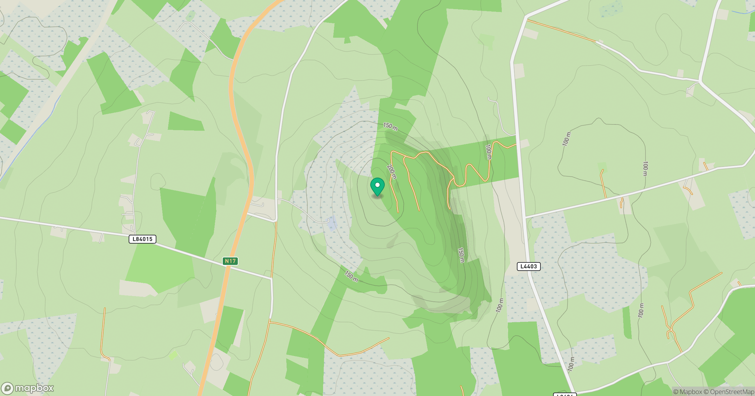
Grid reference: G546148
View on OpenStreetMapOpens a map in a new tab, centred on the hill.
Hills within 30 km
Straight-line distance, not a walking route or confirmation of access.
No comments yet. Be the first.