
Kilmichael Hill
Good walks are even better shared.
Overview
Kilmichael Hill
Kilmichael Hill, at an approachable elevation of 295 meters, stands as a welcoming guardian over the Kyles of Bute. It's a Marilyn, which means it boasts a significant prominence, making this humble hill a favourite pint-sized giant among hikers.
Geology
The hill is primarily composed of Old Red Sandstone, a reminder of a time when this region was under the sea. The fascinating geology here speaks of epochs gone by, with sedimentary layers that tell tales of shifting landscapes. Keep an eye out for the small pockets of volcanic rock that make an appearance; they provide a glimpse into chaotic Earth's formative moments.
Routes
The most popular route starts from Tighnabruaich, making it a prime choice for those who prefer to avoid the roads and indulge in nature's company. It’s approximately 6.5 km and should take around 2.5 hours at a relaxed pace, allowing for plenty of photo ops. The trail weaves through lush woodlands, eventually bursting forth into the open where breathtaking views reward your ascent. A perfect dayhike even for family outings!
Summit Features
Reaching the top, you might be disappointed to find there's no grand monument waiting for you. Instead, there's a lovely grassy knoll that invites you to sit back, relax, and soak in the beauty of your surroundings. Ideal for a picnic—just keep a lookout for any cheeky crows!
Terrain
The terrain is mostly a combination of mixed grassland interspersed with rocky outcrops. Good walking boots are a must due to the occasional muddy section, especially after rain. Stick to the paths, and you shouldn’t go astray.
Views
On a clear day, the views from Kilmichael Hill are nothing short of enchanting. You can gaze over the Kyles of Bute and spot the Isle of Bute shimmering in the distance. The best time to see these sights is during the spring and autumn months when clarity is at its finest, and the weather tends to play nice.
Hazards
Despite the inviting beauty, you should be wary of the fickle Scottish weather. Conditions can turn from sunny to stormy faster than you can say 'frosty morning', so be prepared. And remember, a brisk walk after a rain can mean black mud, so watch your step!
Nearby Summits
If you’re in the mood for more hill bagging, Meall Mor and Benmore are within striking distance and worth the effort.
Access
Parking in Tighnabruaich is convenient, with a small village car park available to the adventurous. If you're relying on public transport, local bus routes will get you there from nearby towns. Once in Tighnabruaich, you’re just a short jaunt from the trailhead.
Facilities
Once back from your hike, several local cafes and a pub await you, offering delightful meals to fill your tummy and recount tales of your adventure. Don't forget to check out the public toilets available in the village—it’s always nice to freshen up after a day out!
History
The name 'Kilmichael' means 'Church of Michael' in Gaelic. This reflects the deep connections to early Christianity in the area. Kilmichael Hill has quietly watched over this land, holding countless stories within its embrace.
Last Words
Whether you're a seasoned hiker or just enjoy a gentle stroll in nature, Kilmichael Hill offers an accessible escape where you can kick back, breathe in the fresh air, and ponder life, the universe, and everything in between. Happy hiking!
Explore routes near Kilmichael Hill
Public walks starting within 80 km of this hill. Nearby does not mean a route reaches the summit; check its map and access before setting out.
No public routes are currently listed within 80 km of Kilmichael Hill on Walkmates. This does not mean there are no paths here. Explore the map and check local access information before planning a walk.
Route planning notes
These notes describe possible approaches, not verified navigable routes or permission to cross land. Check current paths, local access rules and conditions before setting out.
Kilmichael Hill from Tighnabruaich
A gentle ascent that meanders through scenic woodland before opening up to stunning vistas of the Kyles of Bute.
Make a day of it, together
Find someone to share the walk with, or organise a day out along a route you like.
Hill facts and local notes
Classifications
Elevation
269m
884 ft
Prominence
107m
Coordinates
52.7092, -6.3760
T098632
OS Map
62
At the Summit
At the summit, you'll find a small grassy knoll with a picturesque view, but don't expect a fancy trig point or cairn; it's a peaceful promontory for quiet contemplation.
Terrain & Geology
Kilmichael Hill primarily features complex geology dominated by Old Red Sandstone, with interesting sedimentary features and scattered volcanic rock formations. The area showcases a delightful mix that tells the story of Earth's geological past.
Views & Scenery
From the summit, one can enjoy splendid views over the Kyles of Bute, the Isle of Bute, and distant peaks of the Scottish Highlands.
History & Heritage
Name Origin
The name 'Kilmichael' typically suggests a connection to a church (Cill) dedicated to St. Michael, reflecting the area's rich Christian history.
Historical Significance
The hill has served as a subtle landmark for mariners navigating the Kyles of Bute for centuries, steeped in local tales and folklore.
Getting There & Facilities
Check current local access restrictions, parking rules and transport timetables before travelling. These notes do not confirm public access to the summit.
Parking
Parking available at the Tighnabruaich village car park, approximately 2 km from the trailhead.
Public Transport
Bus connections are available from Dunoon and other nearby towns to Tighnabruaich.
Nearby Facilities
There are a few local cafes and pubs in Tighnabruaich where weary hikers can indulge in hearty meals or a refreshing cuppa. Public toilets are also available in the village.
Safety Information
Known Hazards
- Be cautious of sporadic changes in weather; conditions can shift suddenly, particularly in coastal areas. Also, watch for potentially muddy sections after rain.
General Safety Tips
- Check weather conditions before setting out
- Carry appropriate clothing and equipment
- Let someone know your planned route
- Take a map, compass, and GPS device
- Carry emergency supplies: food, water, first aid kit, torch
Hills
Some common questions about the hills answered
Are there group walks up Kilmichael Hill?
Many walkers use Walkmates to join or organise walks with others. You can check for group walks around Kilmichael Hill through the maps
Are there other walkers around Kilmichael Hill?
Activity varies by location and time, but Walkmates lets you see whether others have shared walks or shown interest in this area. Find other people through the walking friends search walking friends for Kilmichael Hill search or of course create your own walk for Kilmichael Hill
Can I organise a walk to Kilmichael Hill?
Yes. If there aren’t any walks listed already, you can create a walk and make it available for others to join.
If you're signed up to Walkmates, you can create a walk to Kilmichael Hill.
How do I find a walk up this hill?
There are often multiple ways to walk this hill, depending on experience and route preference. Walkmates helps you explore walks and routes that others have shared.
Can I suggest a new route up Kilmichael Hill?
Yes. You can suggest or create routes to share with others. Walkmates focuses on the social side of walking, so routes are used to help people organise walks and explore areas together, rather than as detailed navigation tools or route libraries.
Other uses really appreciate knowledgeable walkers sharing their routes. Share your favourite route to Kilmichael Hill here
The is an error or something incorrect about this hill. How do I let you know?
We always strive to keep the information on Walkmates as accurate as possible. If you find an error, please let us know through the contact form and we'll aim to correct it as quickly as possible
Community Discussion
Comments
Location
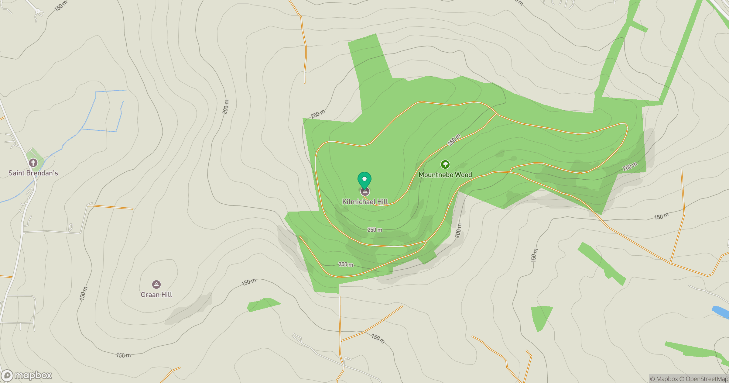
Grid reference: T098632
View on OpenStreetMapOpens a map in a new tab, centred on the hill.
Hills within 30 km
Straight-line distance, not a walking route or confirmation of access.
No comments yet. Be the first.