
Cornaclea Hill
Good walks are even better shared.
Overview
Exploring Cornaclea Hill
Cornaclea Hill, standing proudly at 337 meters, is a Marilyn that invites hikers and nature enthusiasts alike. Nestled in the enchanting Southern Uplands, it offers a delightful blend of natural beauty and moderate hiking challenges.
Geology
The hill is primarily composed of sandstone interspersed with intriguing volcanic rock boulders, painting a picture of the region's complex geological past. You might even feel like a geologist as you explore this ancient landscape, albeit without the fancy tools!
Route Details
The most popular approach begins in the picturesque village of Dalry. The path is clear and meanders through grassy fields, allowing you to soak in the tranquillity of the countryside on your way to the summit. With a distance of approximately 5.5 km and an estimated hiking time of 2.5 hours, this moderate trek is a reachable goal for most outdoor adventurers.
Summit Features
At the peak, you’ll find a small stone cairn and a wooden post marking the summit, effectively making it the cherry on top of your hiking cake. The vista that awaits you at the top is nothing short of breathtaking!
Terrain
Expect a landscape that changes from grassy slopes to rocky outcrops, with a few boggy patches to keep you on your toes. sturdy footwear is recommended, especially in unpredictable weather.
Views
The views from Cornaclea Hill are simply magnificent. To the west, you can see the sprawling Galloway Forest Park, while to the south lies the glittering expanse of Solway Firth. Try to visit in late spring or early autumn for the best chances of clear skies and vibrant colours.
Hazards
As with any outdoor adventure, be prepared for potential hazards. Slippery terrain can be a problem in wet conditions, and the winds can be particularly gusty at the summit, so it’s wise to dress in layers. Remember, safety first!
Access
Accessibility is straightforward, with a small car park in the heart of Dalry, although arriving early is advisable if you want a space on the weekends. For those dependent on public transport, the bus services from nearby towns will bring you close to the action.
Facilities
After your hike, you can stop by the local café for a well-deserved cup of tea and a slice of cake. Facilities such as public toilets are also in the village, ensuring you can refresh before starting your journey home.
Historical Significance
The name 'Cornaclea' has its roots in Gaelic language, giving you a taste of the cultural heritage surrounding this hill. Historically, this area has served as a guidepost for hidden paths and trails, echoing tales of shepherds and wanderers who have traversed its slopes.
In conclusion, whether you're an seasoned hiker or a casual walker, Cornaclea Hill is an excellent choice for a day out in the Southern Uplands. So lace up those hiking boots and get out there—Cornaclea awaits!
Explore routes near Cornaclea Hill
Public walks starting within 80 km of this hill. Nearby does not mean a route reaches the summit; check its map and access before setting out.
No public routes are currently listed within 80 km of Cornaclea Hill on Walkmates. This does not mean there are no paths here. Explore the map and check local access information before planning a walk.
Route planning notes
These notes describe possible approaches, not verified navigable routes or permission to cross land. Check current paths, local access rules and conditions before setting out.
Dalry to Cornaclea
A scenic route starting from Dalry, passing through lush landscapes and rolling hills before ascending to the summit of Cornaclea Hill.
Make a day of it, together
Find someone to share the walk with, or organise a day out along a route you like.
Hill facts and local notes
Classifications
Elevation
269m
883 ft
Prominence
100m
Coordinates
53.9980, -10.1250
F607075
OS Map
22 30
At the Summit
The summit boasts a small stone cairn and a wooden post, serving as a perfect photo opportunity for the summit conqueror. The expansive views are the real highlight, though!
Terrain & Geology
Cornaclea Hill is primarily composed of sandstone with scattered boulders of volcanic rock, giving it a unique blend of geological features. The formations reflect the region's ancient geological activity, providing insights into the area's history.
Views & Scenery
Panoramic views of the Galloway Forest Park to the west and the Solway Firth to the south make the summit well worth the effort. On a clear day, you may even spot the peaks of the Lake District to the southeast.
History & Heritage
Name Origin
The name 'Cornaclea' is believed to be derived from the Gaelic 'Cearn na Cleithe', meaning 'the corner of the slope', reflecting its topographical features.
Historical Significance
Cornaclea Hill has been a landmark for locals for centuries, serving as a starting point for various historic routes and helping guide shepherds and travellers through the region.
Getting There & Facilities
Check current local access restrictions, parking rules and transport timetables before travelling. These notes do not confirm public access to the summit.
Parking
There is a small car park in Dalry, located on the Main Street. Spaces can fill up quickly on sunny weekends, so arrive early!
Public Transport
Regular bus services operate from nearby towns to Dalry, providing a convenient option for those without a car.
Nearby Facilities
The local café in Dalry offers hot drinks and snacks. Public toilets are also available in the village, so you can freshen up before heading out for your adventure.
Safety Information
Known Hazards
- Beware of slippery sections in wet conditions, particularly during the rainy months. Additionally, strong winds can make the summit feel chillier than a chilly morning in your granny's house.
General Safety Tips
- Check weather conditions before setting out
- Carry appropriate clothing and equipment
- Let someone know your planned route
- Take a map, compass, and GPS device
- Carry emergency supplies: food, water, first aid kit, torch
Hills
Some common questions about the hills answered
Are there group walks up Cornaclea Hill?
Many walkers use Walkmates to join or organise walks with others. You can check for group walks around Cornaclea Hill through the maps
Are there other walkers around Cornaclea Hill?
Activity varies by location and time, but Walkmates lets you see whether others have shared walks or shown interest in this area. Find other people through the walking friends search walking friends for Cornaclea Hill search or of course create your own walk for Cornaclea Hill
Can I organise a walk to Cornaclea Hill?
Yes. If there aren’t any walks listed already, you can create a walk and make it available for others to join.
If you're signed up to Walkmates, you can create a walk to Cornaclea Hill.
How do I find a walk up this hill?
There are often multiple ways to walk this hill, depending on experience and route preference. Walkmates helps you explore walks and routes that others have shared.
Can I suggest a new route up Cornaclea Hill?
Yes. You can suggest or create routes to share with others. Walkmates focuses on the social side of walking, so routes are used to help people organise walks and explore areas together, rather than as detailed navigation tools or route libraries.
Other uses really appreciate knowledgeable walkers sharing their routes. Share your favourite route to Cornaclea Hill here
The is an error or something incorrect about this hill. How do I let you know?
We always strive to keep the information on Walkmates as accurate as possible. If you find an error, please let us know through the contact form and we'll aim to correct it as quickly as possible
Community Discussion
Comments
Location
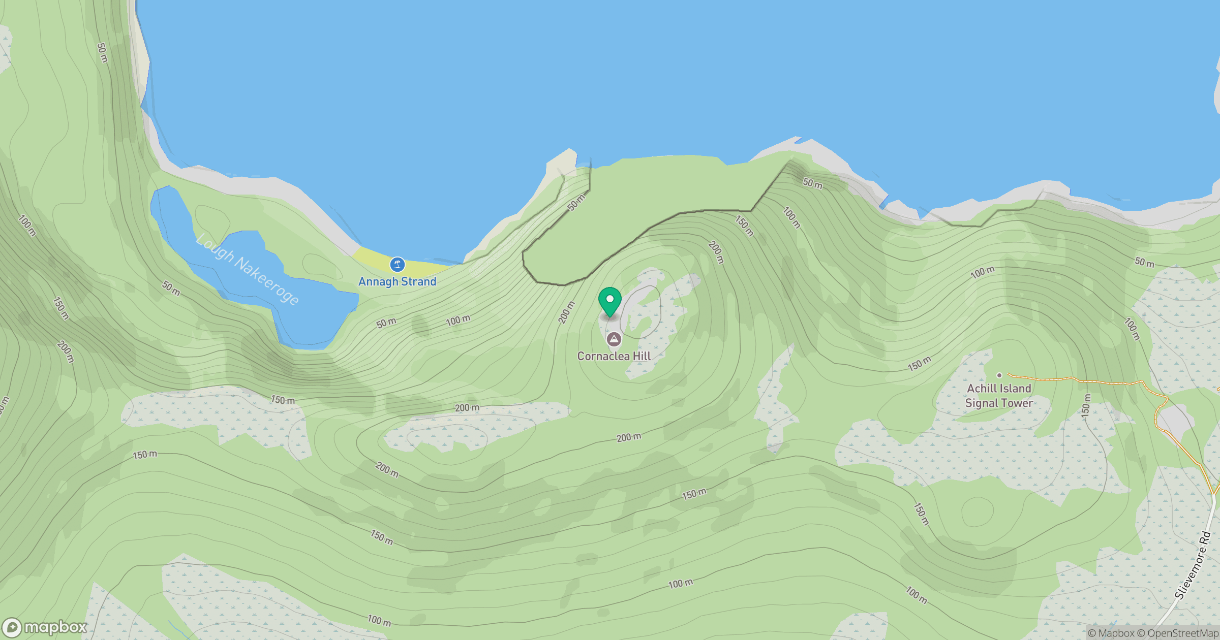
Grid reference: F607075
View on OpenStreetMapOpens a map in a new tab, centred on the hill.
Hills within 30 km
Straight-line distance, not a walking route or confirmation of access.
No comments yet. Be the first.