
Carrowmore Hill
Good walks are even better shared.
Overview
Carrowmore Hill
Overview
Carrowmore Hill, standing proudly at 422 meters, is a Marilyn located in the enchanting Connemara region of County Galway. The hill serves as a gateway to a spectacular landscape that boasts dramatic mountain ranges and serene lakes. Why 'Carrowmore', you ask? Well, it might just be because it's the 'great quarter' place where many a hiker starts their expedition.
Geology
The geology of Carrowmore Hill is a blend of limestone and quartzite. Its formation reveals a fascinating history of ancient marine life, now fossilized within the rock. This geological diversity makes it not just a feast for the eyes but also a treasure trove for geologists and interested trekkers alike.
Routes
Two primary routes lead up to Carrowmore's summit:
- Carrowmore Loop Trail: Ideal for those preferring a more leisurely stroll while soaking in the sights. Expect a distance of 6.2 km and a 2.5-hour adventure to the summit.
- Direct Ascent from Lough Fee: For the more audacious hikers, this steeper route of 3.5 km takes a mere 2 hours but demands a bit more stamina.
Summit Features
Upon reaching the summit, prepare to be greeted by a delightful stone cairn and a wooden post that has weathered many storms. The summit offers breathtaking vistas that are worth every step of the climb.
Terrain Type
Expect a delightful mix of grassy slopes and rocky crags. A solid pair of boots is essential unless you are fond of the soggy sock experience!
Views
From the summit, gaze upon the Twelve Bens, Lough Corrib, and even catch a glimpse of the rugged Atlantic coastline. Visit in late spring or early autumn to experience the landscape at its vibrant best.
Hazards
Do keep your wits about you! Watch out for loose rocks and slippery trails, especially after a spell of rain. Weather can switch faster than a fox on a fence, so check for updates before you set off.
Nearby Summits
Don't miss the chance to explore the nearby Knocklettercussa (418m) and Gleniff Horseshoe (472m) for an extended hiking adventure.
Access
Parking is available at Lough Fee car park, about 3 km from the trailhead. Public transport is an option, with buses running from Galway to Letterfrack, but you'll need to stretch those legs to reach the trails.
Facilities
After a long hike, local cafes in Letterfrack provide a warm welcome and a chance to refuel with hot drinks and snacks. Restrooms are available at the community centre.
History
The etymology of Carrowmore reflects the deep-rooted history of the area. Stone circles and ancient ruins in the vicinity signify a rich cultural heritage.
In summary, Carrowmore Hill is a splendid destination for hikers of varying abilities, presenting a mix of adventure, stunning views, and a dash of history. So, lace up those boots, grab your walking stick, and let's hit the trails!
Explore routes near Carrowmore Hill
Public walks starting within 80 km of this hill. Nearby does not mean a route reaches the summit; check its map and access before setting out.
No public routes are currently listed within 80 km of Carrowmore Hill on Walkmates. This does not mean there are no paths here. Explore the map and check local access information before planning a walk.
Route planning notes
These notes describe possible approaches, not verified navigable routes or permission to cross land. Check current paths, local access rules and conditions before setting out.
Carrowmore Loop Trail
A scenic loop trail that takes you around the base of the hill before ascending to the summit. Ideal for enjoying the surrounding landscape with some gentle inclines.
Direct Ascent from Lough Fee
This is a steeper and more direct ascent from the nearby Lough Fee, offering a more challenging climb with rewarding views.
Make a day of it, together
Find someone to share the walk with, or organise a day out along a route you like.
Hill facts and local notes
Classifications
Elevation
170m
558 ft
Prominence
148m
Coordinates
53.7636, -9.8462
L783809
OS Map
30
At the Summit
The summit features a modest stone cairn and a charmingly weathered wooden post. The panoramic views from the top are the real show-stopper, fetching many hikers back for 'one more look'.
Terrain & Geology
Dominantly composed of limestone with some quartzite outcrops, the geology of Carrowmore Hill tells a story of ancient marine environments, with fossils often found in its rocky interior. The hill's unique features were shaped by both glaciation and erosion.
Views & Scenery
From the summit, you can see the stunning Twelve Bens mountain range, Lough Corrib, and the Atlantic coastline, with the Burren making a noticeable appearance on a clear day.
History & Heritage
Name Origin
The name 'Carrowmore' is derived from the Irish 'Ceathrú Mor', meaning 'great quarter', possibly referring to historical land divisions.
Historical Significance
The area is steeped in history with ancient ruins and stone circles nearby, revealing the long-standing relationship between humans and this picturesque landscape.
Getting There & Facilities
Check current local access restrictions, parking rules and transport timetables before travelling. These notes do not confirm public access to the summit.
Parking
Parking is available at the Lough Fee car park, approximately 3 km from the base of Carrowmore Hill. Limited spaces, but definitely enough for a few cars.
Public Transport
Buses run from Galway city to nearby villages, with a bit of walking required afterwards to reach the trailheads.
Nearby Facilities
There are a couple of local cafes in Letterfrack offering hot drinks and snacks, plus restrooms at the community centre. Bring your own sandwiches if you fancy a picnic on the summit!
Safety Information
Known Hazards
- Loose rock in steeper sections, potentially slippery trails after rain, and sudden changes in weather should be considered.
General Safety Tips
- Check weather conditions before setting out
- Carry appropriate clothing and equipment
- Let someone know your planned route
- Take a map, compass, and GPS device
- Carry emergency supplies: food, water, first aid kit, torch
Hills
Some common questions about the hills answered
Are there group walks up Carrowmore Hill?
Many walkers use Walkmates to join or organise walks with others. You can check for group walks around Carrowmore Hill through the maps
Are there other walkers around Carrowmore Hill?
Activity varies by location and time, but Walkmates lets you see whether others have shared walks or shown interest in this area. Find other people through the walking friends search walking friends for Carrowmore Hill search or of course create your own walk for Carrowmore Hill
Can I organise a walk to Carrowmore Hill?
Yes. If there aren’t any walks listed already, you can create a walk and make it available for others to join.
If you're signed up to Walkmates, you can create a walk to Carrowmore Hill.
How do I find a walk up this hill?
There are often multiple ways to walk this hill, depending on experience and route preference. Walkmates helps you explore walks and routes that others have shared.
Can I suggest a new route up Carrowmore Hill?
Yes. You can suggest or create routes to share with others. Walkmates focuses on the social side of walking, so routes are used to help people organise walks and explore areas together, rather than as detailed navigation tools or route libraries.
Other uses really appreciate knowledgeable walkers sharing their routes. Share your favourite route to Carrowmore Hill here
The is an error or something incorrect about this hill. How do I let you know?
We always strive to keep the information on Walkmates as accurate as possible. If you find an error, please let us know through the contact form and we'll aim to correct it as quickly as possible
Community Discussion
Comments
Location
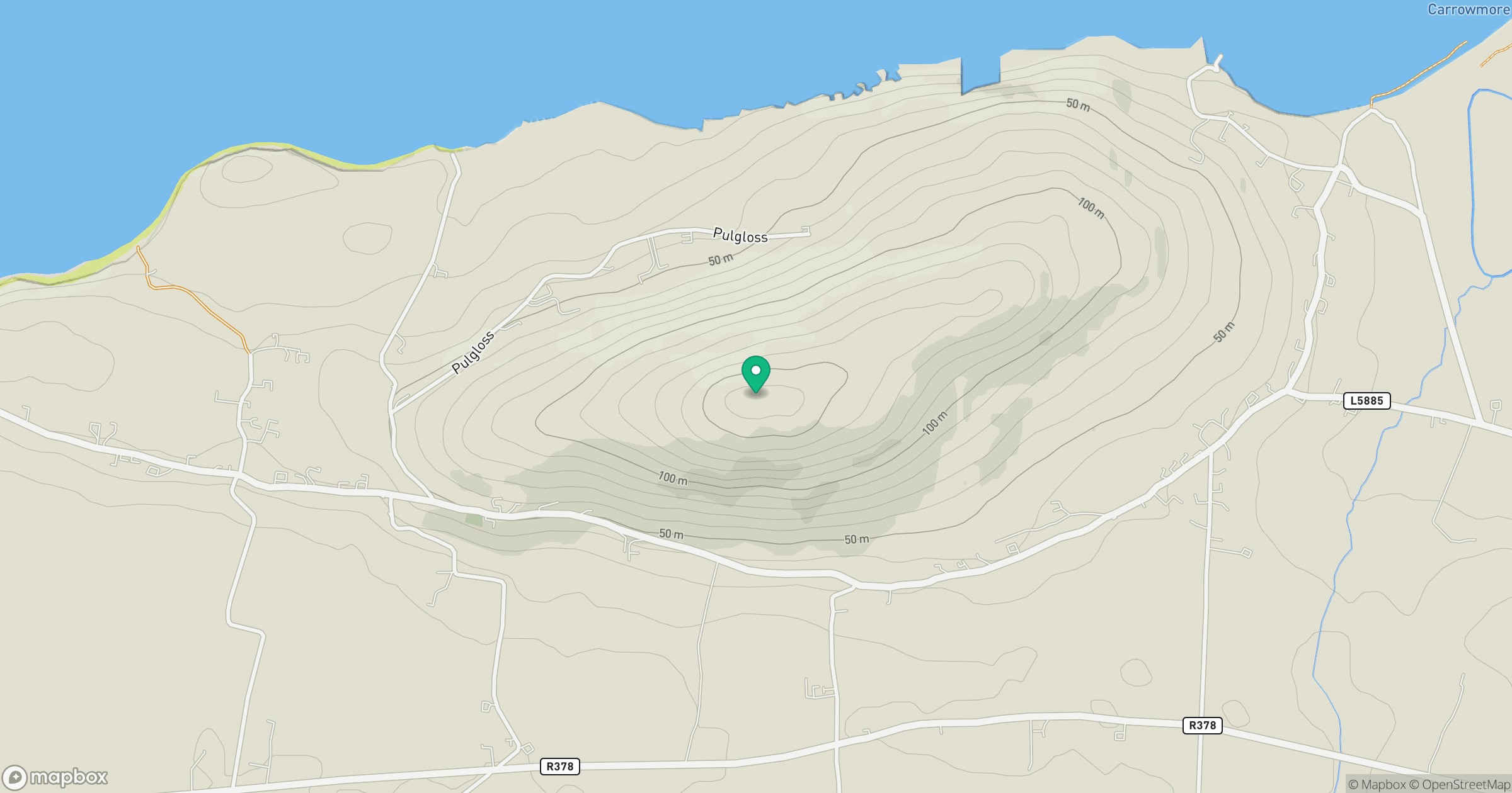
Grid reference: L783809
View on OpenStreetMapOpens a map in a new tab, centred on the hill.
Hills within 30 km
Straight-line distance, not a walking route or confirmation of access.
No comments yet. Be the first.