
Carrigadoon Hill
Good walks are even better shared.
Overview
Carrigadoon Hill
Overview
Carrigadoon Hill, standing proudly at 267 meters, might not be the tallest in the range, but it surely knows how to impress! Nestled in the stunning County Kerry, this Hewitt offers a delightful hike with fantastic views that will make your Instagram followers envious.
Geology
Formed primarily from sandstone, the hill showcases the typical rugged beauty of the region. The romantic weathering of the rock has created unique formations that catch the eye, especially when kissed by the golden rays of the sun.
Routes
Carrigadoon Hill Circuit
This moderately challenging circuit kicks off from a handy roadside location. The 6-kilometre trail weaves through enchanting landscapes, flirtatiously blending paths with open moorland. Expect some company in the form of local sheep—you may need to charm them for the best selfie!
Summit Features
Upon reaching the summit, you'll find a charming stone cairn standing like a mini stonehenge! Don’t forget to take a photo; your loved ones won’t believe you nearly tackled the crumbly rocks leading uphill!
Terrain
The ground is a delightful mishmash of grassy patches and rocky outcrops, with a few rebellious heather patches that remind you where you are. Just bear in mind, the terrain can shift beneath your feet—rooting for your step may not be an odd sight here.
Views
From the summit, the views are nothing short of spectacular. You can gaze upon the Macgillycuddy's Reeks and Lough Leane. My advice is to leave your worries behind and soak in the sights—the stress of city living will seem a world away.
Best Seasons for Views
Avoid winter unless you're keen on practicing your survival skills! Spring and autumn are your best bets for stunning views and pleasant hiking conditions. Early mornings also provide a magical light—perfect for those who enjoy a peaceful start to the day.
Hazards
As with any hike, be aware of your surroundings. Keep an eye out for loose rocks, particularly on the ascent, and prepare yourself for the frequent changes in the weather—after all, this is Ireland!
Access
Nearest Parking
Limited roadside parking is available near the trailhead. Arrive early to nab a good spot, or risk parking several sheep away!
Public Transport
Bus services to Killarney will get you close, with taxis available to whisk you to the foot of the hill.
Nearest Town
The charming town of Killarney is just a stone's throw away, brimming with life and all the essential facilities you might need.
Facilities
In Killarney, you’ll find a plethora of cafes and restaurants waiting to serve up something tasty after your adventurous day. Plus, public toilets are conveniently found in town.
History
Name Meaning
The name Carrigadoon translates to 'black rock' in Irish. One can imagine the stories held by these often-glossy stones.
Significance
Carrigadoon Hill holds a special place for both locals and hikers. It’s an accessible hike that connects people with nature and breathes life into local folklore and wildlife.
So, lace up those boots and get ready to conquer Carrigadoon Hill—just don’t forget to pack a snack for the summit and perhaps a little bit of common sense on your way back down!
Happy hiking!
Explore routes near Carrigadoon Hill
Public walks starting within 80 km of this hill. Nearby does not mean a route reaches the summit; check its map and access before setting out.
No public routes are currently listed within 80 km of Carrigadoon Hill on Walkmates. This does not mean there are no paths here. Explore the map and check local access information before planning a walk.
Route planning notes
These notes describe possible approaches, not verified navigable routes or permission to cross land. Check current paths, local access rules and conditions before setting out.
Carrigadoon Hill Circuit
A pleasant loop starting at the nearby road, offering a mix of paths and open moorland.
Make a day of it, together
Find someone to share the walk with, or organise a day out along a route you like.
Hill facts and local notes
Classifications
Elevation
297m
974 ft
Prominence
143m
Coordinates
52.4115, -7.4067
S404289
OS Map
75
At the Summit
The summit is crowned with a small stone cairn, providing a perfect photo opportunity, especially on a clear day.
Terrain & Geology
The hill is primarily composed of sandstone, which has weathered over time to create the stunning views and rolling landscape surrounding it.
Views & Scenery
Panoramic views of the surrounding countryside, including glimpses of the Macgillycuddy's Reeks and Lough Leane, the largest of the Lakes of Killarney.
History & Heritage
Name Origin
The name 'Carrigadoon' is thought to derive from the Irish 'Carraig Dubh,' meaning 'black rock.'
Historical Significance
It's a popular spot for both locals and tourists seeking a day hike with remarkable views and local wildlife.
Getting There & Facilities
Check current local access restrictions, parking rules and transport timetables before travelling. These notes do not confirm public access to the summit.
Parking
There is limited roadside parking near the starting point of the route via the R569.
Public Transport
The closest bus stop is in Killarney, from which a taxi can be taken to the foot of the hill.
Nearby Facilities
There are several cafes, restaurants, and public toilets in Killarney, as well as numerous shops for those last-minute essentials.
Safety Information
Known Hazards
- Watch out for loose rocks on the ascent and be prepared for rapidly changing weather conditions.
General Safety Tips
- Check weather conditions before setting out
- Carry appropriate clothing and equipment
- Let someone know your planned route
- Take a map, compass, and GPS device
- Carry emergency supplies: food, water, first aid kit, torch
Hills
Some common questions about the hills answered
Are there group walks up Carrigadoon Hill?
Many walkers use Walkmates to join or organise walks with others. You can check for group walks around Carrigadoon Hill through the maps
Are there other walkers around Carrigadoon Hill?
Activity varies by location and time, but Walkmates lets you see whether others have shared walks or shown interest in this area. Find other people through the walking friends search walking friends for Carrigadoon Hill search or of course create your own walk for Carrigadoon Hill
Can I organise a walk to Carrigadoon Hill?
Yes. If there aren’t any walks listed already, you can create a walk and make it available for others to join.
If you're signed up to Walkmates, you can create a walk to Carrigadoon Hill.
How do I find a walk up this hill?
There are often multiple ways to walk this hill, depending on experience and route preference. Walkmates helps you explore walks and routes that others have shared.
Can I suggest a new route up Carrigadoon Hill?
Yes. You can suggest or create routes to share with others. Walkmates focuses on the social side of walking, so routes are used to help people organise walks and explore areas together, rather than as detailed navigation tools or route libraries.
Other uses really appreciate knowledgeable walkers sharing their routes. Share your favourite route to Carrigadoon Hill here
The is an error or something incorrect about this hill. How do I let you know?
We always strive to keep the information on Walkmates as accurate as possible. If you find an error, please let us know through the contact form and we'll aim to correct it as quickly as possible
Community Discussion
Comments
Location
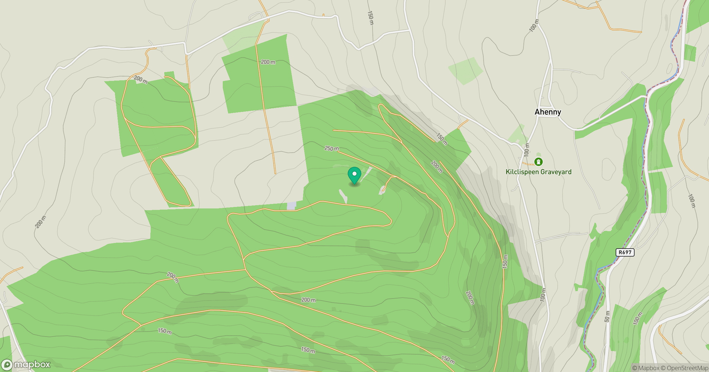
Grid reference: S404289
View on OpenStreetMapOpens a map in a new tab, centred on the hill.
Hills within 30 km
Straight-line distance, not a walking route or confirmation of access.
Slievenamon [Sliabh na mBan]
720m
Croughaun Hill
391m
Kilclooney Mountain [Fauscoum]
792m
Knockanaffrin [Cnoc an Aifrinn]
755m
Knocknamuck [Cnoc na Muc]
340m
No comments yet. Be the first.