
Aghalion Hill
Good walks are even better shared.
Overview
Aghalion Hill
Nestled in the scenic Southern Uplands, Aghalion Hill may not be the tallest in the vicinity, but it certainly packs a punch when it comes to beauty and views. Standing at 234 meters, this Marilyn invites hikers to explore its grassy slopes and rocky features, promising a delightful adventure.
Geology
The geology of Aghalion Hill is a tale of ancient sedimentary layers. Composed mainly of mudstone and sandstone, this hill gives a glimpse into the Earth's history, dating back to the Carboniferous period. Whether you’re a budding geologist or simply a curious hiker, the fascinating geological formations provide ample food for thought.
Routes and Trails
One of the most popular routes is the Aghalion Hill Circular trail. Starting from Dalbeattie, this 6.5 km loop is a moderate hike that takes approximately 2.5 hours to complete. Expect lush woodlands, stunning views from the summit, and perhaps a friendly chat with fellow adventurers along the way.
Summit Features
At the top, you’ll find a modest cairn and a trig point that sits patiently awaiting your arrival. It’s as if they’re saying, 'Hey, join the club!' A perfect spot for a picture or to take a break and enjoy the panoramic views.
Terrain and Hazards
The terrain is grassy with some rocky patches, appealing to those who enjoy a bit of variety. However, be mindful of muddy areas, particularly after a rainfall, as well as uneven ground - a few careless steps might leave you with a muddy behind!
Views
On a clear day, the views from Aghalion Hill are nothing short of spectacular. You can see the rolling hills of the Southern Uplands and enjoy a glimpse of the Solway Firth. Do keep an eye out for the iconic Criffel Hill in the distance, waving at you like an old friend.
Access
Getting to Aghalion Hill is straightforward. The nearest parking lot is conveniently located in Dalbeattie. A brisk 30-minute stroll from the bus stop (if you choose public transport) serves as a great warm-up before the hike.
Facilities
Once back in Dalbeattie, treat yourself to a refreshing drink or a bite to eat at one of the local cafés. There are also public toilets to wash off the remnants of your hike.
History
The name 'Aghalion' has an intriguing etymology, derived from 'Aghal' - meaning 'rocky place', reflecting both the rugged beauty and the Gaelic and Norse heritage of the area. Local folklore intertwines with history, showing just how significant these hills once were as natural boundaries.
Whether you're a seasoned hiker or just fancy a leisurely stroll with a view, Aghalion Hill is ready to welcome you with open arms and unforgettable memories.
Happy Hiking!
Explore routes near Aghalion Hill
Public walks starting within 80 km of this hill. Nearby does not mean a route reaches the summit; check its map and access before setting out.
Florence Court: Riverside and Forest Circuit, County Fermanagh
View route
Scarva to Poyntzpass: Newry Canal and Lough Shark Return
View route
Peatlands Park Red Trail: Annagarriff Wood and Derryadd Lough
View route
Portadown to Knock Bridge: Bann Boulevard and Moneypenny’s Lock
View route
Route planning notes
These notes describe possible approaches, not verified navigable routes or permission to cross land. Check current paths, local access rules and conditions before setting out.
Aghalion Hill Circular
A scenic loop starting from the village of nearby Dalbeattie, taking you through lush woodlands and up to the summit with panoramic views.
Make a day of it, together
Find someone to share the walk with, or organise a day out along a route you like.
Hill facts and local notes
Classifications
Elevation
249m
817 ft
Prominence
141m
Coordinates
53.8477, -7.1651
N550890
OS Map
35
At the Summit
The summit features a modest cairn and a small trig point, both perfect for a photo opportunity or a good chinwag with fellow hikers.
Terrain & Geology
Aghalion Hill is primarily made up of sedimentary rocks, with layers of mudstone and sandstone forming its rugged slopes. The area is characterized by ancient geological formations that date back to the Carboniferous period, making it a fascinating spot for geology enthusiasts.
Views & Scenery
From the summit, you can see the rolling hills of the Southern Uplands and even catch a glimpse of the Solway Firth on a clear day. Keep an eye out for the distinctive Criffel Hill in the distance!
History & Heritage
Name Origin
The name 'Aghalion' is believed to derive from 'Aghal' meaning 'rocky place' in a combination of languages reflecting both Gaelic and Norse influences.
Historical Significance
Historically, the hills have served as a natural boundary and have been important in local folklore.
Getting There & Facilities
Check current local access restrictions, parking rules and transport timetables before travelling. These notes do not confirm public access to the summit.
Parking
Car park in Dalbeattie located at GPS 55.0900, -2.2160, providing a few spaces for vehicles.
Public Transport
Regular bus services connect Dalbeattie with Dumfries, though a brisk 30-minute walk from the bus stop to the trailhead is required.
Nearby Facilities
Cafés and small shops in Dalbeattie provide refreshments, along with public toilets for a pre- or post-hike pit stop.
Safety Information
Known Hazards
- Beware of muddy patches and uneven terrain, especially after rain. As always, watch your step and mind your ankles!
General Safety Tips
- Check weather conditions before setting out
- Carry appropriate clothing and equipment
- Let someone know your planned route
- Take a map, compass, and GPS device
- Carry emergency supplies: food, water, first aid kit, torch
Hills
Some common questions about the hills answered
Are there group walks up Aghalion Hill?
Many walkers use Walkmates to join or organise walks with others. You can check for group walks around Aghalion Hill through the maps
Are there other walkers around Aghalion Hill?
Activity varies by location and time, but Walkmates lets you see whether others have shared walks or shown interest in this area. Find other people through the walking friends search walking friends for Aghalion Hill search or of course create your own walk for Aghalion Hill
Can I organise a walk to Aghalion Hill?
Yes. If there aren’t any walks listed already, you can create a walk and make it available for others to join.
If you're signed up to Walkmates, you can create a walk to Aghalion Hill.
How do I find a walk up this hill?
There are often multiple ways to walk this hill, depending on experience and route preference. Walkmates helps you explore walks and routes that others have shared.
Can I suggest a new route up Aghalion Hill?
Yes. You can suggest or create routes to share with others. Walkmates focuses on the social side of walking, so routes are used to help people organise walks and explore areas together, rather than as detailed navigation tools or route libraries.
Other uses really appreciate knowledgeable walkers sharing their routes. Share your favourite route to Aghalion Hill here
The is an error or something incorrect about this hill. How do I let you know?
We always strive to keep the information on Walkmates as accurate as possible. If you find an error, please let us know through the contact form and we'll aim to correct it as quickly as possible
Community Discussion
Comments
Location
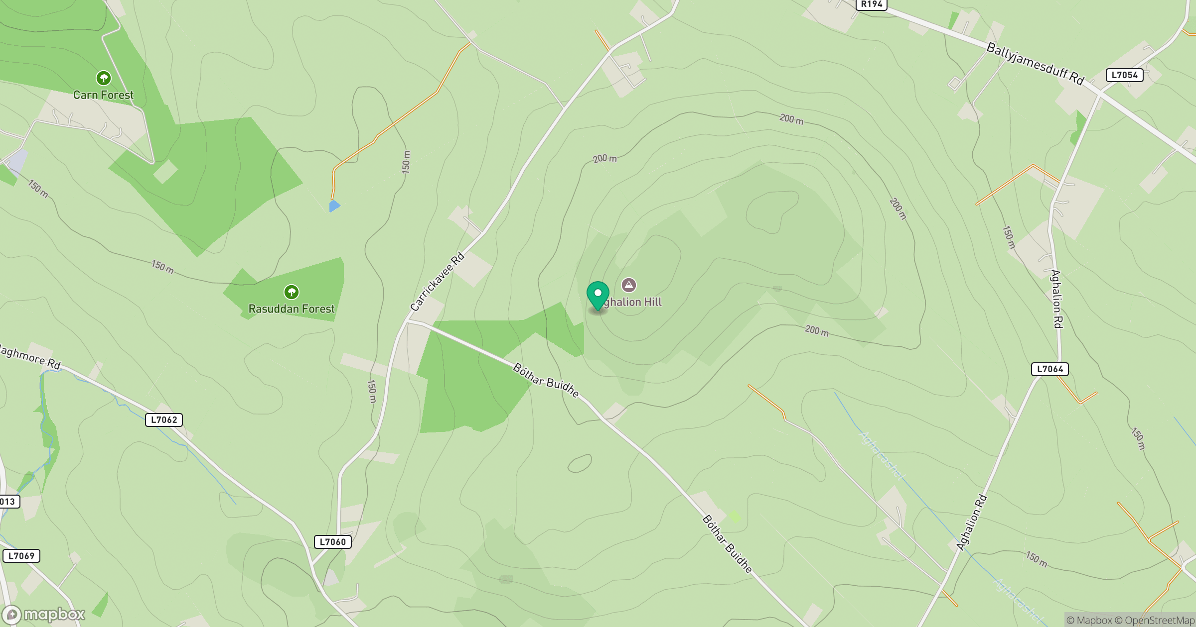
Grid reference: N550890
View on OpenStreetMapOpens a map in a new tab, centred on the hill.
Hills within 30 km
Straight-line distance, not a walking route or confirmation of access.
No comments yet. Be the first.