
Duntryleague Hill
Good walks are even better shared.
Overview
Duntryleague Hill
Duntryleague Hill at 346 meters (1,135 feet) may not be the tallest giant on the block, but it certainly packs a punch with its outstanding views and charming trails. Nestled in County Limerick, this Hewitt is ideal for those looking to enjoy a day out in nature without the intense labour of some of its taller neighbours.
Geology
This gentle giant is composed mainly of limestone, which has been shaped over millennia to create stunning rocky formations and lush grassland. If you take a moment to study the ground beneath your feet, you might just find a fossil or two – a tangible piece of ancient marine history.
Popular Routes
The most popular route is the Doon Road to Summit hike, which spans around 3.5 km and is usually completed in about 1.5 hours. This path is family-friendly and great for leisurely strolls. If you're up for a bit more adventure, try the Duntryleague Loop at 5.2 km, which offers varied landscapes and beautiful views, taking approximately 2.5 hours.
Summit Features
Reaching the summit, hikers are greeted by a stone cairn that serves as a landmark. A viewfinder gives an overview of the majestic surroundings, which can come in handy when you want to impress your friends with your knowledge of the local pubs.
Terrain
Expect a mix of grassy fields interspersed with rocky outcrops. Be cautious of the occasional boggy patches, especially after rain, as they can be deceiving.
Views
On a clear day, the vistas from Duntryleague are nothing short of spectacular! From the summit, you'll take in views of Limerick City, the Shannon River, and surrounding hills, making it an Instagram-worthy spot.
The best seasons for visiting are spring and autumn when flora flourishes and temperatures are mild. Bring your camera and your best selfie stick!
Hazards
While the trails are relatively safe, don’t let your guarding down. Slippery rocks after rainfall and tricky boggy areas can catch you by surprise. Steady on, and mind your footing!
Access
There’s ample parking at the foot of Doon Road. For those relying on public transport, buses frequently run from Limerick to Doon. The nearest town is Doon itself, which boasts quaint shops and cafes.
Facilities
Doon has a handful of cafes and shop facilities for hikers. However, for toilet breaks, you might want to pop into a local pub; they generally welcome weary travelers!
History
The name 'Duntryleague' comes from the Irish Dún Trí Liag, which translates to 'the fort of the three flagstones'. This area has historical significance tied to local clans, making it not only a scenic stop but also a journey back in time.
Whether you are a seasoned hiker or a curious wanderer, Duntryleague Hill offers a delightful escapade through nature, history, and breathtaking views that won’t break the bank—or your spirit!
Happy hiking!
Explore routes near Duntryleague Hill
Public walks starting within 80 km of this hill. Nearby does not mean a route reaches the summit; check its map and access before setting out.
No public routes are currently listed within 80 km of Duntryleague Hill on Walkmates. This does not mean there are no paths here. Explore the map and check local access information before planning a walk.
Route planning notes
These notes describe possible approaches, not verified navigable routes or permission to cross land. Check current paths, local access rules and conditions before setting out.
Doon Road to Summit
A straightforward ascent along well-maintained paths, perfect for a gentle hike with family or friends.
Duntryleague Loop
This loop offers a slightly longer trek with varied terrain and beautiful views.
Make a day of it, together
Find someone to share the walk with, or organise a day out along a route you like.
Hill facts and local notes
Classifications
Elevation
278m
912 ft
Prominence
140m
Coordinates
52.4062, -8.3225
R781283
OS Map
73
At the Summit
The summit features a well-established stone cairn and a lightning fast viewfinder to locate the best pubs in the surrounding areas.
Terrain & Geology
Primarily composed of limestone, with stunning karst formations. The area is rich in geological history, showcasing ancient marine sediments.
Views & Scenery
Panoramic views of Limerick City, the Shannon River, and the surrounding hills make for a perfect selfie backdrop.
History & Heritage
Name Origin
The name 'Duntryleague' is believed to derive from the Irish 'Dún Trí Liag', meaning 'the fort of the three flagstones'.
Historical Significance
The area has historical ties to old Gaelic clans and offers a glimpse into Ireland's past.
Getting There & Facilities
Check current local access restrictions, parking rules and transport timetables before travelling. These notes do not confirm public access to the summit.
Parking
Parking is available at the foot of Doon Road, with space for several cars.
Public Transport
Buses run regularly from Limerick to Doon; check local schedules for exact times.
Nearby Facilities
Doon has a few cafes and shops, but for toilets, the local pubs will be your best bet.
Safety Information
Known Hazards
- Watch for slippery rocks after rain and unexpected boggy areas which can easily trip you up – best not to take a tumble!
General Safety Tips
- Check weather conditions before setting out
- Carry appropriate clothing and equipment
- Let someone know your planned route
- Take a map, compass, and GPS device
- Carry emergency supplies: food, water, first aid kit, torch
Hills
Some common questions about the hills answered
Are there group walks up Duntryleague Hill?
Many walkers use Walkmates to join or organise walks with others. You can check for group walks around Duntryleague Hill through the maps
Are there other walkers around Duntryleague Hill?
Activity varies by location and time, but Walkmates lets you see whether others have shared walks or shown interest in this area. Find other people through the walking friends search walking friends for Duntryleague Hill search or of course create your own walk for Duntryleague Hill
Can I organise a walk to Duntryleague Hill?
Yes. If there aren’t any walks listed already, you can create a walk and make it available for others to join.
If you're signed up to Walkmates, you can create a walk to Duntryleague Hill.
How do I find a walk up this hill?
There are often multiple ways to walk this hill, depending on experience and route preference. Walkmates helps you explore walks and routes that others have shared.
Can I suggest a new route up Duntryleague Hill?
Yes. You can suggest or create routes to share with others. Walkmates focuses on the social side of walking, so routes are used to help people organise walks and explore areas together, rather than as detailed navigation tools or route libraries.
Other uses really appreciate knowledgeable walkers sharing their routes. Share your favourite route to Duntryleague Hill here
The is an error or something incorrect about this hill. How do I let you know?
We always strive to keep the information on Walkmates as accurate as possible. If you find an error, please let us know through the contact form and we'll aim to correct it as quickly as possible
Community Discussion
Comments
Location
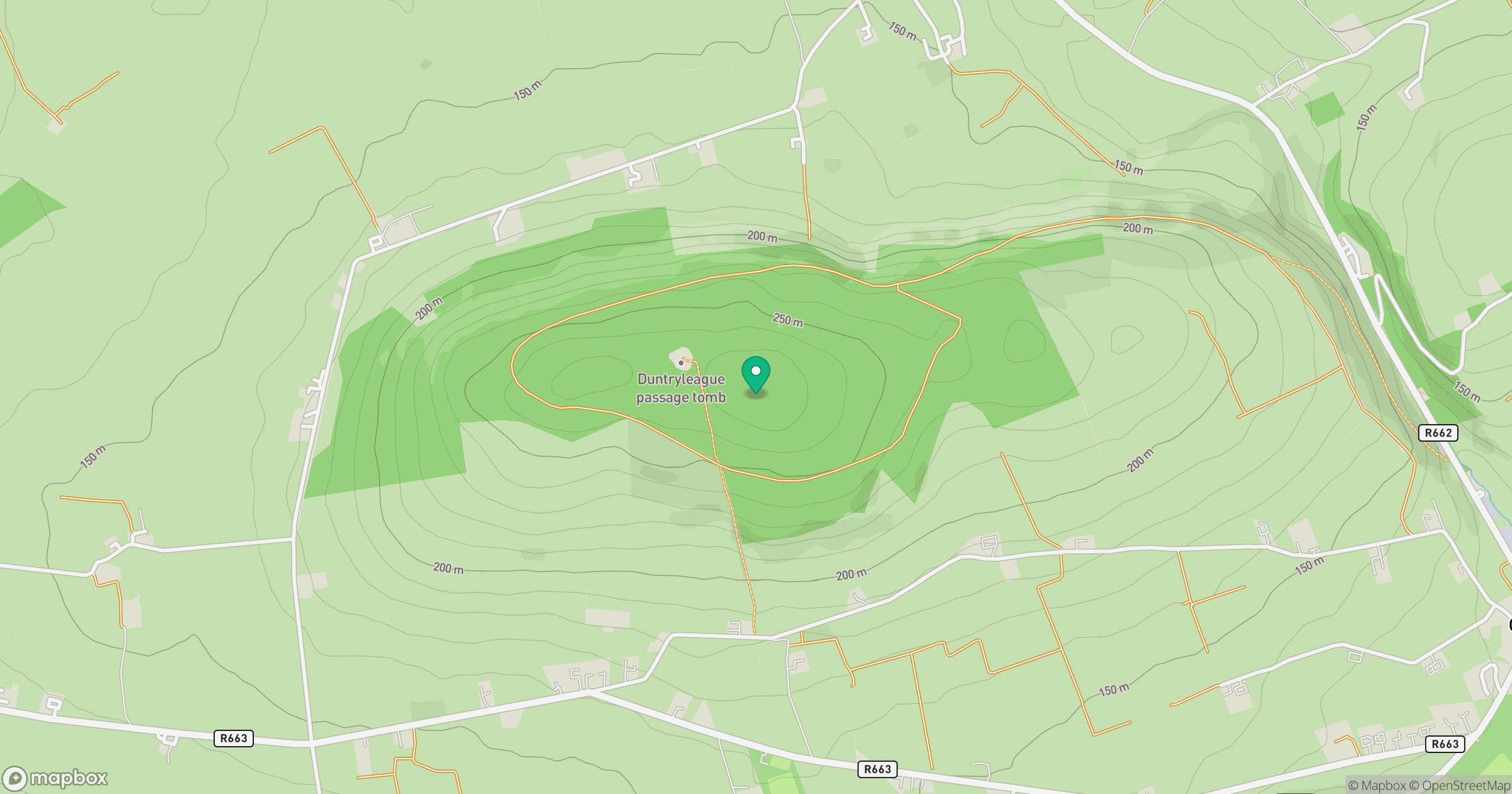
Grid reference: R781283
View on OpenStreetMapOpens a map in a new tab, centred on the hill.
Hills within 30 km
Straight-line distance, not a walking route or confirmation of access.
No comments yet. Be the first.