

Croaghmore (Great Blasket Island)
Good walks are even better shared.
V2495 : Croaghmore, the summit of Great Blasket Island
Michael Earnshaw Photo source
Overview
Introduction
Croaghmore, perched proudly on Great Blasket Island, presents itself as a magnificent escape for hikers eager to embrace untouched nature. At an elevation of 200 meters, it may not challenge the giants of the Irish landscape, but its beauty and views are nothing short of majestic.
Geology
The mountain's geology is a blend of Old Red Sandstone that has weathered through time to form this dramatic landscape. Erosion has sculpted striking features, with rocky outcrops and dramatic cliffs reminiscent of an artist's brushwork.
Routes
Great Blasket Island Loop
This moderate loop starts from where the ferry docks. Be prepared to encounter rocky terrain, interspersed with lush grasses and the occasional bog. The entire route is around 7.5 km and generally takes about three hours, allowing plenty of time to enjoy the sights without any hiccups.
Summit Features
Upon reaching the summit, you are greeted with a sizable cairn, a perfect spot to take a breather or snap a selfie with the breathtaking backdrop. With a bit of luck, you might even catch a glimpse of the elusive puffins bobbing about the cliffs!
Terrain Type
Expect a mix of rocky paths and grassy knolls. However, do keep an eye out for boggy sections! They love to play hide and seek with your boots.
Views
The views from Croaghmore's summit are like icing on a cake! One can see the stunning Dingle Peninsula stretching out, with the Atlantic waves crashing against the cliffs. Spring and early summer provide the best visibility, as well as a vibrant palette of wildflowers.
Hazards
While the ascent isn't overly treacherous, it is prudent to be mindful of quickly changing weather conditions on the island. Fog can shroud the area unexpectedly. Also, footing on rocky trails can be tricky, so tread carefully!
Nearby Summits
Take a peek at nearby An Tiaracht and Mount Eagle if you're feeling adventurous. Both offer additional hiking opportunities with their own unique views.
Access
Getting to Great Blasket Island is part of the adventure! Park at Dingle Harbour and hop a ferry to the island. Public buses connect from Tralee and Dingle, so plan accordingly. The closest town is Dingle, well-known for its charm and colourful facades.
Facilities
Remember, this is a wild and wonderful place with no facilities. Bring your own snacks and perhaps a thermos of tea. Enjoy your picnic on the summit while toasting the panoramic views!
Conclusion
Croaghmore on Great Blasket Island is not just a hike; it’s a delightful adventure that immerses you in nature and history. So grab your boots, pack a sandwich, and make your way to this hidden gem – where nature and adventure await, and memories are just a summit away!
Explore routes near Croaghmore (Great Blasket Island)
Walks starting near this hill. Open a route to check its map, distance and full itinerary.
Route planning notes
These notes describe possible approaches. Check a route's map and access information when planning your walk.
Great Blasket Island Loop
A circular route that starts from the landing point on Great Blasket Island and takes you around the scenic landscape leading to Croaghmore.
Make a day of it, together
Find someone to share the walk with, or organise a day out along a route you like.
Photo Gallery
View all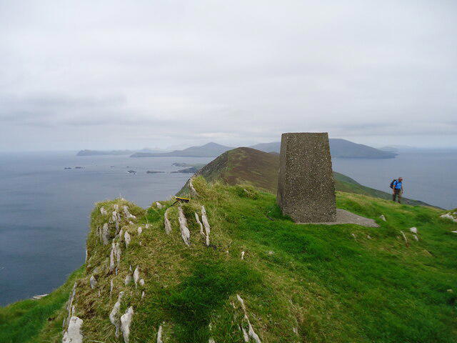 Photo could not load
V2495 : Croaghmore, the summit of Great Blasket Island
Michael Earnshaw
Hill facts and local notes
Classifications
Elevation
289m
948 ft
Prominence
289m
Coordinates
52.0869, -10.5595
V246958
OS Map
70
At the Summit
The summit features a prominent cairn made of local stone and provides a panoramic view that is truly worth the climb.
Terrain & Geology
The mountain is primarily composed of Old Red Sandstone, with its rugged cliffs showcasing numerous geological features shaped by erosional processes.
Views & Scenery
From the summit, hikers can enjoy stunning views of the surrounding Atlantic Ocean, the Dingle Peninsula, and the nearby Blasket Islands.
History & Heritage
Name Origin
Croaghmore, meaning 'Big Hill' in Irish, reflects the mountain's prominent stature.
Historical Significance
The island holds historical significance as a vibrant community until the 1950s and is now a natural and cultural heritage site.
Getting There & Facilities
Parking
Parking is available at Dingle Harbour, from where you can take a ferry to the island.
Public Transport
Buses run from Tralee and Dingle to the ferry terminal.
Nearby Facilities
There are no facilities on Great Blasket Island, so pack your picnic and enjoy it at the summit!
Safety Information
Known Hazards
- Fog can roll in quickly, reducing visibility. Watch for loose stones on the trails.
General Safety Tips
- Check weather conditions before setting out
- Carry appropriate clothing and equipment
- Let someone know your planned route
- Take a map, compass, and GPS device
- Carry emergency supplies: food, water, first aid kit, torch
Hills
Some common questions about the hills answered
Are there group walks up Croaghmore (Great Blasket Island)?
Many walkers use Walkmates to join or organise walks with others. You can check for group walks around Croaghmore (Great Blasket Island) through the maps
Are there other walkers around Croaghmore (Great Blasket Island)?
Activity varies by location and time, but Walkmates lets you see whether others have shared walks or shown interest in this area. Find other people through the walking friends search walking friends for Croaghmore (Great Blasket Island) search or of course create your own walk for Croaghmore (Great Blasket Island)
Can I organise a walk to Croaghmore (Great Blasket Island)?
Yes. If there aren’t any walks listed already, you can create a walk and make it available for others to join.
If you're signed up to Walkmates, you can create a walk to Croaghmore (Great Blasket Island).
How do I find a walk up this hill?
There are often multiple ways to walk this hill, depending on experience and route preference. Walkmates helps you explore walks and routes that others have shared.
Can I suggest a new route up Croaghmore (Great Blasket Island)?
Yes. You can suggest or create routes to share with others. Walkmates focuses on the social side of walking, so routes are used to help people organise walks and explore areas together, rather than as detailed navigation tools or route libraries.
Other uses really appreciate knowledgeable walkers sharing their routes. Share your favourite route to Croaghmore (Great Blasket Island) here
The is an error or something incorrect about this hill. How do I let you know?
We always strive to keep the information on Walkmates as accurate as possible. If you find an error, please let us know through the contact form and we'll aim to correct it as quickly as possible
Community Discussion
Comments
Location
View the hill's mapped position and surrounding paths.
Grid reference: V246958
View on OpenStreetMapOpens a map in a new tab, centred on the hill.
No comments yet. Be the first.