

Beinn fo Thuath
Good walks are even better shared.
Overview
Beinn fo Thuath
Nestled in the heart of the Scottish Highlands, Beinn fo Thuath is not just any ordinary mountain; it's a Munro that beckons hikers with its rugged charm and stunning views. Standing at an elevation of 948 meters, it promises a rewarding day out for all.
Geography and Geology
As you approach the mountain, you'll notice its impressive basalt cliffs that tell stories of volcanic activity from ages past. The geology here is fascinating, with layers of ancient lavas and rock formations providing a colourful backdrop for your adventure.
Routes
North West Ridge Route
This popular route attracts many outdoor enthusiasts. Starting from the Lochearnhead Car Park, it traverses the North West ridge, providing stunning vistas that just might make you forget about that second breakfast. At 7 km, this moderately challenging walk generally takes about 4 hours and is suitable for most hikers.
South East Approach
For those craving a more vigorous challenge, the South East Approach, stretching 10 km, is perfect. This path winds through beautiful glens and up the steeper southeastern slopes of Beinn fo Thuath, taking approximately 5.5 hours to complete. This route may provide a bit more of a workout, so dust off those hiking boots!
Summit Features
Reaching the summit feels like an achievement worth celebrating. The large stone cairn marks the high point aficionado's paradise, ideal for epic selfies—don’t forget to strike a pose!
Terrain and Conditions
Expect a mix of rocky trails and grassy sections. However, watch out for the occasional boggy patch—nobody enjoys squelching in their boots. Good footwear will save the day.
Views and Best Seasons
The summit rewards you with panoramic views of Loch Earn and the Trossachs. Best visited in spring and early autumn, you can enjoy vibrant scenery without fighting the elements too much. And if you’re lucky, you'll spot some wildlife along the way!
Hazards
Seven layers of weather can come at you unexpectedly in the Highlands, so ensure you’re prepared. Loose rocks and muddy patches may also pose a challenge on your ascent.
Nearby Summits
Feeling energetic? Nearby Beinn Dubh and Ben Vorlich offer additional hiking opportunities to extend your adventure in this beautiful region.
Access and Facilities
Conveniently located near Lochearnhead, Beinn fo Thuath is accessible via local roads with ample parking. After your hike, consider hitting one of the local cafes for a well-deserved treat. Toilets are also available nearby.
Conclusion
Beinn fo Thuath is more than just a mountain; it’s a Scottish icon. Its enjoyable hiking routes and spectacular views make it a beloved destination for outdoor lovers.
To truly appreciate all this Munro has to offer, make sure to set aside a day for exploration. Just remember to bring your usual hiking fare, a sense of adventure, and possibly a walking buddy who can help lighten the load—especially in bad weather!
Thanks for considering Beinn fo Thuath for your hiking plans. Happy trails!
Explore routes near Beinn fo Thuath
Public walks starting within 80 km of this hill. Nearby does not mean a route reaches the summit; check its map and access before setting out.
Beautiful private beach walk Isle of Harris
View route
Berneray Community Hall to the beautiful beach
View route
Route planning notes
These notes describe possible approaches, not verified navigable routes or permission to cross land. Check current paths, local access rules and conditions before setting out.
North West Ridge Route
This route begins at the car park near the village of Lochearnhead and follows the scenic North West ridge to the summit, offering views of the surrounding valleys.
South East Approach
A slightly longer trek, this route from the village of Balquhidder meanders through lush glens and takes you up the south eastern slopes of the mountain.
Make a day of it, together
Find someone to share the walk with, or organise a day out along a route you like.
Photo Gallery
View all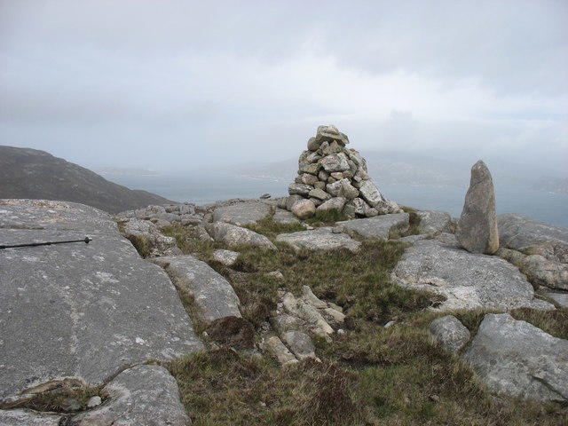 Photo could not load
NA9814 : The summit of Beinn fo Thuath
David Purchase
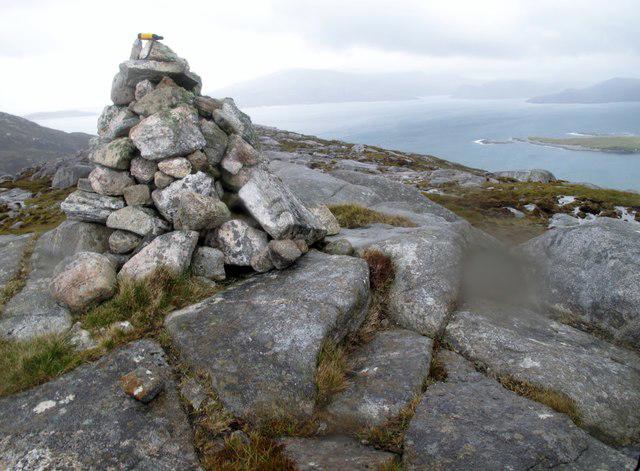 Photo could not load
NA9814 : Beinn fo Thuath, Scarp
Rude Health
Hill facts and local notes
Classifications
Elevation
179m
587 ft
Prominence
113m
Coordinates
58.0142, -7.1129
NA981142
OS Map
13
Explorer: 456
At the Summit
The summit of Beinn fo Thuath is marked by a large stone cairn, which offers a perfect spot for a summit selfie—just make sure it's not a 'cairn' of bad puns.
Terrain & Geology
Beinn fo Thuath presents a classic example of the volcanic geology that characterises much of the Scottish Highlands. It is composed primarily of ancient basalt lavas, which provide a rich tapestry of colour and texture as one climbs.
Views & Scenery
From the summit, you can enjoy breathtaking views of Loch Earn, the surrounding peaks of the Trossachs, and on a clear day, even the distant hills of the Southern Highlands.
History & Heritage
Name Origin
The name 'Beinn fo Thuath' translates to 'Mountain of the North', a fitting title given its majestic presence in the landscape.
Historical Significance
This mountain has been a popular spot for hikers and climbers for centuries, and like many Scottish hills, it is steeped in local folklore.
Getting There & Facilities
Check current local access restrictions, parking rules and transport timetables before travelling. These notes do not confirm public access to the summit.
Parking
There is parking available at the Lochearnhead Car Park, which accommodates several vehicles. Ensure to arrive early during peak seasons.
Public Transport
Local bus services operate to Lochearnhead from larger towns. Check the latest schedules to ensure a hassle-free trip.
Nearby Facilities
Loch Earn has a few quaint cafes and restaurants that offer refreshments and toilet facilities. Always good to refuel!
Safety Information
Known Hazards
- Be mindful of sudden weather changes, loose rocks, and the potential for boggy patches in lower areas. Good footwear is recommended!
General Safety Tips
- Check weather conditions before setting out
- Carry appropriate clothing and equipment
- Let someone know your planned route
- Take a map, compass, and GPS device
- Carry emergency supplies: food, water, first aid kit, torch
Hills
Some common questions about the hills answered
Are there group walks up Beinn fo Thuath?
Many walkers use Walkmates to join or organise walks with others. You can check for group walks around Beinn fo Thuath through the maps
Are there other walkers around Beinn fo Thuath?
Activity varies by location and time, but Walkmates lets you see whether others have shared walks or shown interest in this area. Find other people through the walking friends search walking friends for Beinn fo Thuath search or of course create your own walk for Beinn fo Thuath
Can I organise a walk to Beinn fo Thuath?
Yes. If there aren’t any walks listed already, you can create a walk and make it available for others to join.
If you're signed up to Walkmates, you can create a walk to Beinn fo Thuath.
How do I find a walk up this hill?
There are often multiple ways to walk this hill, depending on experience and route preference. Walkmates helps you explore walks and routes that others have shared.
Can I suggest a new route up Beinn fo Thuath?
Yes. You can suggest or create routes to share with others. Walkmates focuses on the social side of walking, so routes are used to help people organise walks and explore areas together, rather than as detailed navigation tools or route libraries.
Other uses really appreciate knowledgeable walkers sharing their routes. Share your favourite route to Beinn fo Thuath here
The is an error or something incorrect about this hill. How do I let you know?
We always strive to keep the information on Walkmates as accurate as possible. If you find an error, please let us know through the contact form and we'll aim to correct it as quickly as possible
Community Discussion
Comments
Location
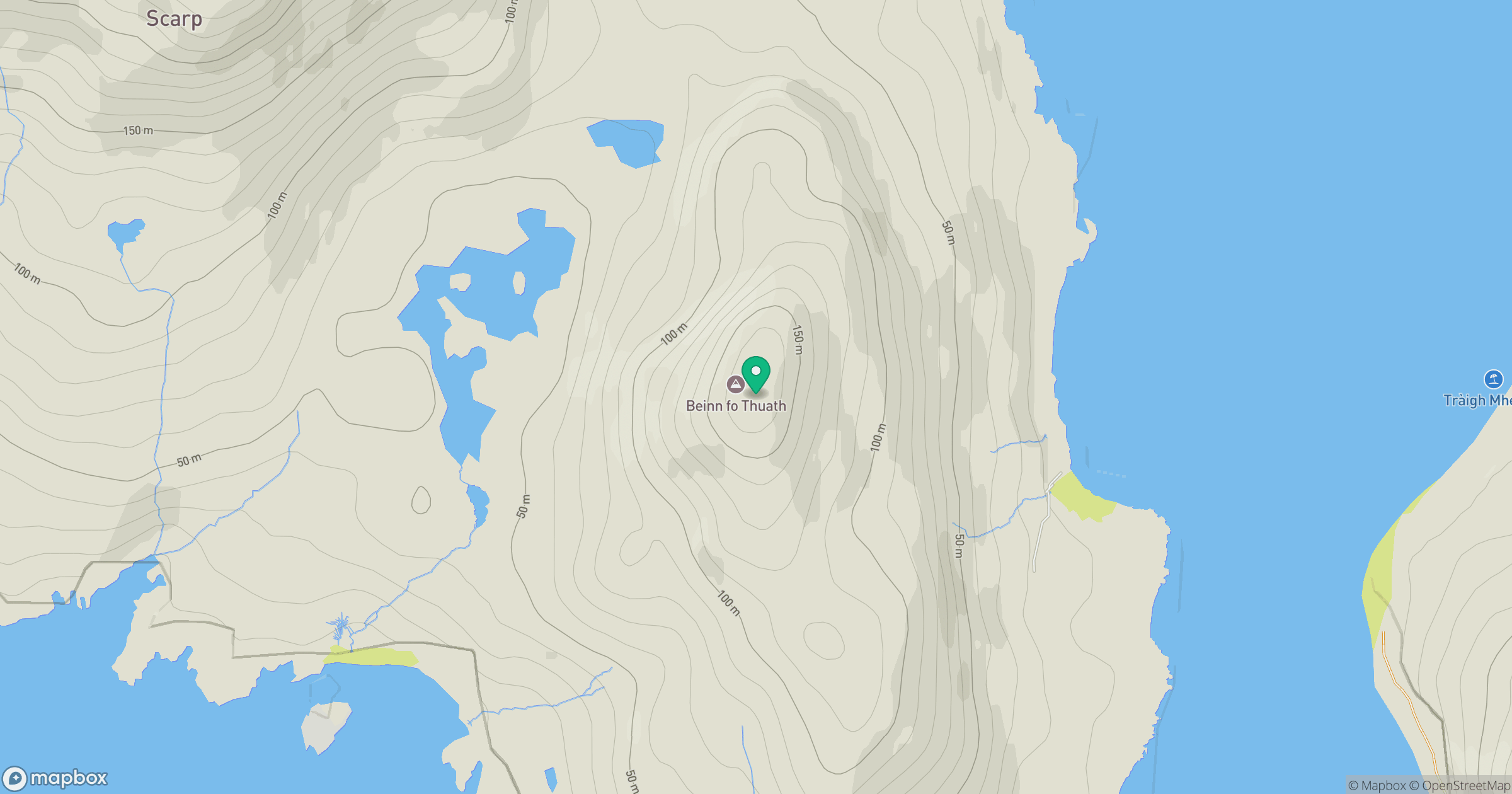
Grid reference: NA981142
View on OpenStreetMapOpens a map in a new tab, centred on the hill.
Hills within 30 km
Straight-line distance, not a walking route or confirmation of access.
An Cliseam [Clisham]
800m
Sron Romul
308m
Huiseabhal Mor [Husival Mor]
489m
Meall nan Sithean [Meall nan Sidhean]
177m
Mullach na h-Airde Bige
182m
No comments yet. Be the first.