
Walking guides
Plessey Woods walk: short circuits, riverside paths and access
Choose a Plessey Woods outing with clear short and longer route options, current riverside cautions, parking and practical access advice.
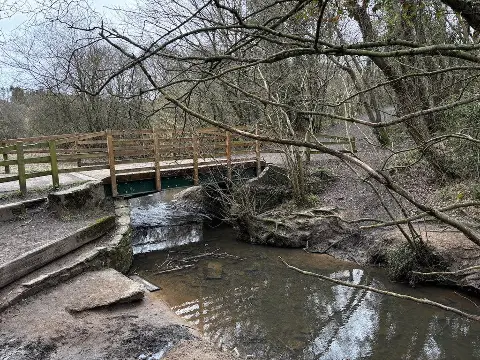
Plessey Woods is a good place to leave room for a wander. Woodland, open grass and the River Blyth sit close together, with a visitor centre at the entrance and several ways to make an outing shorter or longer. The useful first decision is how much of the park you want to explore.
You will find different distances attached to a “Plessey Woods walk”. The council describes an approximately 2.5 km circuit; Countryfile publishes a separate 5.2 km route. Choose the outing that fits your time and the ground you are happy to tackle.
Check the riverside before setting off. A British Orienteering course notice, checked on 10 November 2026, reports a landslip closing the riverside path towards former checkpoint 33. It does not give a notice date or establish which other published walking routes are affected. Check signs and ask at the visitor centre about your intended path. Follow closures and diversions rather than trying to complete a loop through a barrier.
Choose the outing that suits your day
A short woodland wander with an easy return decision
If you have young children, limited time or uncertain energy, start from the visitor centre and choose a short out-and-back on a path you can comfortably retrace. Decide when to turn before anyone is tired. This approach lets you enjoy the woods without committing to a river circuit whose return may involve more difficult ground.
There is no fixed distance for this choice. Keep track of your outward journey, and remember that a downhill outward stretch means climbing back. Stop to look at a stream or listen to the birds instead of adding distance simply because another path continues.
The council's approximately 2.5 km park circuit
The council's park information describes a full circuit of about 1½ miles, or 2.5 km, including steep steps and grassy paths. That is a short distance, but it deserves more thought than a flat pavement stroll.
The Plessey Woods Short Circular on Walkmates is a useful starting point for planning a visit. Before following a trace, compare it with the current park information and any signs on the ground. An advertised distance cannot confirm that every path remains passable after a landslip or bad weather.
Countryfile's longer 5.2 km walk
Countryfile's Plessey Woods walk is listed as 3.3 miles/5.2 km, moderate, with an estimated two hours. Its description includes woodland and a steep descent towards the River Blyth gorge. Treat this as a separate outing, with its own directions and greater time allowance, rather than an alternative measurement of the short circuit.
The guide dates from 2021. Check current access before using it, especially around the river. Allow extra time for stops and any signed diversion; do not plan your return to the car around an exact two-hour finish.
Start at the visitor centre
Use Plessey Woods Country Park visitor centre, Shields Road, near Hartford Bridge, NE22 6HZ, off the A192. The main car park is beside the entrance facilities. Check the named destination as well as the postcode when setting navigation, and use the entrance shown on the council's park page.
Before leaving the entrance, take a moment to establish three things: your intended route, whether any paths are closed, and when you need to be back. A photograph of the current information board is more useful than relying on an old screenshot when standing at a junction later.
Steps, slopes and wet ground
There are surfaced paths from the visitor centre into the woods, but steep riverside gradients make the whole circuit an unsuitable promise of step-free access. If you use a wheelchair, mobility aid or pushchair, ask which specific stretch currently fits your needs. Check the return gradient as well as the outward surface.
Wet leaves and mud can make a modest walk slower. Wear footwear with dependable grip and keep enough daylight for a cautious return. British Orienteering specifically warns about slippery river-edge paths and high water. Give the edge space, keep children close and turn back if a path is flooded or its condition is doubtful. A shorter woodland visit is still a worthwhile day out. The River Blyth gauge at Hartford Bridge can help you check conditions before travelling, but a normal reading does not certify that a path is safe or open.
For a gentle visit, choose the terrain first and let the distance follow. A short, comfortable stretch with a rest can be more enjoyable than reaching the nominal end of a circuit.
Parking, toilets and a café stop
Parking charges checked on 10 November 2026 are first hour free, up to two hours £3, over two hours £5. Blue Badge holders park free with the badge displayed. Read the machine and gate notices when you arrive, including the vehicle closing time.
The park and toilets operate during daylight hours. The café has seasonal opening hours and is closed on Mondays; check the current opening information before making it your lunch plan. Bring water and a snack so a closed café does not determine how far you can comfortably walk.
Leave room in your parking allowance for the walk back, a toilet stop and getting everyone ready to leave. The free first hour is not a target for completing a woodland circuit.
Dogs and a slower look at the woods
Dogs are welcome in the park. Follow the Countryside Code: keep them under control, clean up after them and follow local signs. A lead is a sensible choice beside steep banks, around other visitors and near livestock; do not assume a quiet-looking riverside is safe for a swim.
The Woodland Trust's park entry highlights the River Blyth's wildlife, including kingfishers and otters. Sightings are a possibility, not an attraction on a timetable. Pause quietly where the path is safe, watch from a distance and leave the bank and vegetation undisturbed.
If conditions make Plessey a poor fit, our Northumberland woodland walks guide offers other places to consider. For Plessey itself, the best plan is a clear start, a suitable path and no pressure to complete a circuit if a shorter walk suits you better.
Photograph: Bridge over Pegwhistle Burn in Plessey Woods Country Park, © David Robinson / Geograph, CC BY-SA 2.0. Taken 2 March 2026. Unmodified.