
Walking guides
Make a day of Hadrian’s Wall without walking the whole trail
Choose a manageable Hadrian’s Wall outing by comparing Walltown, Steel Rigg and Housesteads, then plan the terrain, bus connections and return journey.
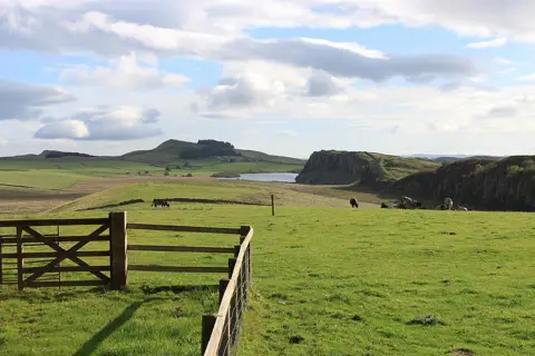
A day beside Hadrian’s Wall can mean a gentle wander around a country park, a short-looking walk with plenty of climbing, or a longer circuit across the central crags. The trick is to choose the kind of day you want before choosing a distance. Four miles over steep steps can ask more of you than a longer walk on an even surface.
Start with two decisions: how much rough ground you want, and how you will get back. Then leave room for the things that brought you here — looking across the landscape, stopping at the Wall, or visiting a Roman fort. This is a guide to choosing your outing, not turn-by-turn directions: use the linked official route maps and check local notices before you set off.
Choose the ground before the mileage
For a gentler visit, keep to Walltown Country Park
Walltown Country Park has traffic-free paths around its ponds, including flexi-paved, wheel-friendly paths. It is a useful option when an outing with room to pause matters more than completing a long stage of the Wall Path.
Keep the distinction between the country park and the crags above it clear. The surfaced paths do not make the whole surrounding landscape step-free, and they are not a promise that every route onto Hadrian’s Wall will suit a wheelchair or pushchair. Choose the actual path you intend to use rather than treating “Walltown” as a single accessibility description.
The National Park lists the visitor centre and Tramper hire as seasonal, April to September, while toilets and the Changing Places facility are listed as open around the clock throughout the year. Check the current visitor information before relying on any facility; a quieter off-season visit should not depend on refreshments or mobility-equipment hire being available.
For a compact crag walk, look at the Steel Rigg circular
The National Park’s Steel Rigg and Crag Lough route is a 4-mile / 6.5km circular from Steel Rigg View car park. Its moderate grade sits alongside a more useful description: short, sharp climbs, steep stone steps, stiles and potentially muddy ground, with steep drops from the crags.
Choose it for the landscape, not because four miles sounds automatically easy. Everyone in the party needs to be comfortable with the ground as well as the distance. Wet stone, a strong wind or a slower pace on the steps can change how manageable it feels.
The downloadable guide is an older document and still describes the former tree at Sycamore Gap. Use its route information alongside current notices, not as a guide to what every landmark or facility looks like today. Carry the map rather than relying on a remembered photograph of the view.
For a longer outing, compare the Housesteads–Steel Rigg circuit
The National Trust’s Housesteads to Steel Rigg circular is a different route: 8 miles / 12.8km, starting and finishing at the Housesteads visitor-centre area. It follows public footpaths with steep climbs and descents, stone-pitched paths and potentially muddy sections.
This is the choice for a fuller walking day, provided the terrain and conditions suit your group. Do not confuse it with the shorter Steel Rigg loop or assume that visiting the fort fits inside a walking-time estimate. A fort visit, lunch and time at viewpoints all belong in the day's budget.
The fort is a separate attraction with its own admission arrangements; parking is also charged, including for National Trust members. Check both before leaving. Neither a membership card nor a walking route description should be taken as a guarantee of free parking.
Sort out the return journey first
A circular walk brings you back to its starting point. A linear walk needs a second plan: getting back from the finish. That distinction matters more than which direction looks prettier on a map.
The local bus formerly branded AD122 is now service 122. Go North East says it runs daily throughout the year apart from Christmas Day, Boxing Day and New Year’s Day. Older walk descriptions still describe a summer-only service, so use the operator’s current information rather than an old route leaflet for transport planning.
The service page and timetable connect Hexham and Haltwhistle with stops serving places including Housesteads, The Sill and Walltown. Select your travel date and check the exact stop, direction and return journey. “Served by the bus” does not mean the stop is at the start of your chosen walking route.
Steel Rigg is a particularly useful example. The National Park’s visitor information directs bus passengers to The Sill, then uphill along the narrow road towards Steel Rigg. That approach is extra walking beyond a circuit measured from the car park, and needs its own judgement about road conditions and suitability.
For a linear outing, taking the bus first and walking back towards your starting place can reduce the pressure of chasing a return service. It is a planning option, not a guarantee: still check disruptions and have a workable alternative. Do not build a day around the last bus with no allowance for slower ground or a missed connection.
Give the fort and the walk their own time
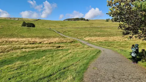

Housesteads is not a flat, effortless substitute for a crag walk. English Heritage’s access guide describes a 750-metre uphill approach on rough gravel, with a steep gradient, and uneven ground around the fort. Read the detailed access information if steps, slopes or surfaces will affect your visit.
Check current opening and facilities information separately from the walk. Check which toilets and refreshments are open before relying on a stop at Housesteads. Carry the food and drink you need and identify a confirmed stop before setting out.
Make the whole day fit
Before committing, write down the walking route, any approach from a bus stop, your stops and your return plan. Compare that whole outing with the daylight available, rather than putting a published walking estimate next to sunset and hoping they fit. Our guide to planning a walk within daylight helps turn those pieces into a realistic finish time.
Use a current map to check the actual start and finish, the climbs and the paths between them. If the line and contours are unfamiliar, reading a walking route map is a useful place to start. A short route with awkward ground may be the wrong choice even when you have plenty of time.
Keep dogs on leads where the route guidance requires it, respect livestock and follow local signs. The Countryside Code is also a useful reminder to check the weather, carry appropriate equipment, tell someone your plan and be willing to turn back. A phone is helpful, but rural signal is not something to build the day around.
You do not need to collect a particular number of miles to have a worthwhile day here. Choose the ground you will enjoy, make the journey home straightforward and leave enough time to stop.