
Walking guides
Duncombe Terrace walk: choosing your Ashridge outing
Choose a Duncombe Terrace walk at Ashridge: compare route options, understand the distances, and plan parking, mobility access and transport.
Duncombe Terrace is a useful Ashridge choice when you want woodland and time to look around without committing to a long circuit. Start by deciding how far you want to go along the terrace, then leave enough time to retrace your steps. That simple decision matters more here than picking the smallest mileage you find online.
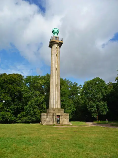
The starting area is the Ashridge Estate visitor centre beside the Bridgewater Monument, reached along Monument Drive near Ringshall. Duncombe Terrace leads away through the woods towards Clipper Down. This guide helps you choose an outing and plan your arrival; use the linked route information and current estate signs for navigation.
Three ways to plan your Ashridge walk
A shorter woodland wander
Follow a suitable stretch of the terrace and return the same way when you have had enough. Agree a turnaround time before starting, particularly if you are meeting transport or walking with people whose pace differs. There is no need to reach Clipper Down to make the outing worthwhile.
Check the return while you still feel comfortable. A half-hour outward walk still leaves a walk back, and stopping to watch wildlife or take photographs adds time without adding distance.
The plotted Walkmates out-and-back
Our Ashridge Duncombe Terrace and Clipper Down route lists 4.9 km / 3 miles, with an estimated two hours. Its plotted itinerary starts by the visitor-centre car park, reaches the Clipperdown Cottage junction and retraces its path. Keep outside the cottage grounds.
Those figures belong to that particular plotted route, rather than every walk called Duncombe Terrace. Allow extra time for your group's pace, pauses and conditions. No ascent figure is given here.
A longer walk from the railway station
If you want to make the train journey part of a fuller day, the Chilterns National Landscape's Pitstone Hill, Ashridge and Aldbury circuit is a separate six-mile route from Tring station. It includes Duncombe Terrace, but also hills, steps, gates and road crossings.
Choose it for the whole itinerary, not as an interchangeable way of reaching the short terrace walk. Adding a station approach to another route changes both the effort and the distance.
Check what your distance includes
The National Trust's trail page gives 2 miles / 3.2 km and 1 hour 40 minutes. Its final stage reaches Clipper Down and tells walkers to return, while its start and finish fields both name the visitor centre. That leaves the distance's relationship to the return unclear.
Do not treat 3.2 km as a confirmed total for the Walkmates itinerary, or double it and call the result verified. Compare the actual turnaround on your chosen map. If a strict distance limit matters, check the intended section with the visitor centre before setting off.
Continuing towards Ivinghoe Beacon is another decision again. Plan that extension and the return as a whole rather than following an enticing sign and assuming the original time estimate still applies.
Surfaces and mobility: look beyond the easy label
The Trust identifies Duncombe Terrace as a surfaced, linear mobility route. Its detailed estate access statement also warns that the surfaced mobility paths can be uneven and very muddy in bad weather. That is more useful for planning than assuming a woodland trail will always be firm and dry.
For a wheelchair, mobility scooter or pushchair, consider the whole visit: the path from the parking area, the stretch you intend to follow, the turn back and access to toilets. Ask about current conditions if any of those details could decide whether the outing works for you.
The estate's accessibility information explains Blue Badge parking and the seasonal mobility-vehicle service. Advance booking is recommended. Borrowing a vehicle has its own time limit and approved routes; do not assume it covers the full walk you have planned.
Parking has changed
Use Monument Drive and the visitor-centre area, not an arbitrary Ashridge postcode or the monument itself as a driving destination. The National Trust's current parking update says parking remains free, but the north verge of Monument Drive is no longer available. That is the right-hand side as you drive towards the monument.
Follow the current signs to permitted spaces. Busy-day meadow parking is conditional, so do not build your plans around it being open. Arrange a recognisable meeting point with your companions after parking rather than expecting everyone to find adjacent spaces.
Toilets and the outdoor-seating café are near the visitor centre. Check the estate's current opening information if either is important to your day, and carry what you need for the walk.
Coming without a car
HertsLynx is a bookable, demand-responsive option to investigate, rather than a bus you can assume will appear at a fixed time. The estate identifies an Ashridge – Bridgewater Monument stop. Check actual outward and return availability through Intalink's HertsLynx Dacorum information.
The operator currently lists Monday–Saturday hours of 7 am–7 pm and Sunday/bank-holiday hours of 10 am–4 pm. Its booking system may offer ordinary public transport instead when that can fulfil the journey. Those operating hours do not guarantee a particular booking, a connection or enough daylight for your walk.
Leave a return buffer for stops and slower ground. If walking from Tring station, choose a checked connecting route and include it in the day's distance; the terrace-only distance does not include your journey from the train.
A woodland visit with time to notice things
The Bridgewater Monument makes a distinctive starting landmark. Built in 1831–32 to commemorate Francis, third Duke of Bridgewater, it is a Grade II* listed structure. You can appreciate it from outside without making a climb part of the walk; check separate admission and opening arrangements if you want to go up.
Ashridge Commons and Woods forms part of the Chilterns Beechwoods Special Area of Conservation. The protected landscape includes beech woodland alongside other habitats. Staying on the paths and clearing up after dogs helps reduce pressures such as trampling and dog fouling. Leave wildlife room and follow the estate's lead requirements and local signs.
For a relaxed group outing, settle three things before you arrive: where to meet, where to turn around and when you need to be back. Our guide to choosing a walk that suits you can help if the group wants different things from the day.
Last checked: 23 October 2026. Check current estate notices and transport availability before travelling.