

Woolacombe Down
Good walks are even better shared.
SS4642 : Dedication on trig pillar on Challacombe Hill (S1601)
Gary Rogers Photo source
Overview
Woolacombe Down: A Hiker's Delight
Woolacombe Down, standing at 93 meters, offers a gentle yet rewarding hiking experience nestled in the stunning North Devon landscape. This Marilyn mountain, with a prominence of 38 meters, invites both seasoned hikers and newcomers alike to explore its grassy slopes.
Geology
The geological composition of Woolacombe Down is fascinating, boasting sandstones and mudstones that date back to the Mesozoic era. The surrounding area provides stunning coastal scenery, showcasing unique rock formations nearby that are worth checking out for geology enthusiasts.
Hiking Routes
The primary route to the summit, starting from Woolacombe beach, stretches about 3.5 km and takes around 1.5 hours to complete. This easy trail is ideal for families and those looking to enjoy a leisurely walk surrounded by nature.
Summit Features
At the top, you'll find a charming grassy knoll crowned by a stone shelter, perfect for a quick munch and taking in the breathtaking views. Remember, the only thing better than a good view is a good view with snacks!
Terrain
Expect a lovable mix of grassy paths and the occasional rocky outcrop. The gentle slopes provide a perfect playground for those who enjoy the outdoors, though a little caution is wise after rainfall—the grass can become a bit of a slip-and-slide!
Views
The views from the summit are nothing short of spectacular. Gaze out to the Atlantic Ocean and the soft golden sands of Woolacombe beach below, with Exmoor hills standing majestically in the distance, especially remarkable during the vibrant hues of autumn or the bright days of spring and summer.
Hazards
While Woolacombe Down is generally safe, be mindful of wet conditions that can make the paths slippery. Also, keep an eye out for sheep; they may have dibs on the best grazing spots!
Access
Getting to Woolacombe Down is a cinch with ample public parking available at Woolacombe beach. The nearest bus连接 from Barnstaple makes it even easier for those galumphing in from further afield.
Facilities
After your hike, why not treat yourself? Woolacombe town is brimming with cafes and eateries where you can relish a hot drink or a hearty meal. Plus, public toilets are readily available—because let's face it, nature calls!
History
The name 'Woolacombe' comes from Old English, translating to 'Cwm of the Wool'—a nod to its historical roots in sheep farming and its development as a fashionable seaside resort since the Victorian era.
Woolacombe Down might be petite in stature, but it certainly packs a punch with its natural beauty and charm. So grab your boots, bring some snacks, and make your way to this delightful spot in North Devon!
Explore routes near Woolacombe Down
Walks starting near this hill. Open a route to check its map, distance and full itinerary.
Braunton Walk with Men Walking & Talking
View route
Lynmouth, Watersmeet and Ash Bridge woodland circuit
View route
Milton Damerel Level 3 walk
View route
Cookworthy Woods Level 2 walk
View route
Route planning notes
These notes describe possible approaches. Check a route's map and access information when planning your walk.
Woolacombe to Woolacombe Down
A scenic trail that ascends from the beach through lush grassland, offering stunning views of the North Devon Coast.
Make a day of it, together
Find someone to share the walk with, or organise a day out along a route you like.
Photo Gallery
View all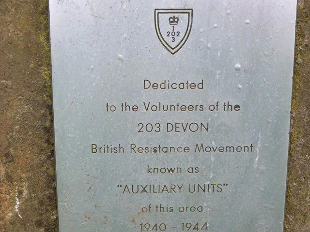 Photo could not load
SS4642 : Dedication on trig pillar on Challacombe Hill (S1601)
Gary Rogers
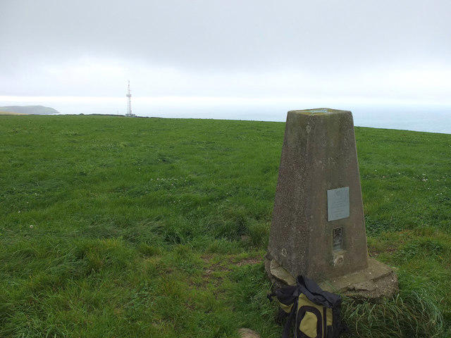 Photo could not load
SS4642 : Trig Pillar on Challacombe Hill (S1601)
Gary Rogers
Hill facts and local notes
Classifications
Elevation
199m
653 ft
Prominence
37m
Coordinates
51.1648, -4.1917
SS468429
OS Map
180
Explorer: 139
At the Summit
The summit features a grassy hilltop that boasts a prominent stone shelter, perfect for a quick sit and a bite to eat while admiring the view.
Terrain & Geology
Woolacombe Down is predominantly composed of sandstones and mudstones from the Mesozoic era, providing a rich geological tapestry that records millions of years of earth's history. A fine example of coastal geology is present nearby, where you can see stratified rock formations.
Views & Scenery
From the summit, hikers can enjoy panoramic vistas of the Atlantic coastline, the sandy beaches of Woolacombe, and on clear days, the towering Exmoor hills to the east.
History & Heritage
Name Origin
The name 'Woolacombe' is derived from the Old English, meaning 'Cwm' (a valley or hollow) of the 'Wool' – unsurprising given the area's rich sheep farming history.
Historical Significance
Historically, Woolacombe has been a popular resort since the Victorian era and continues to be a beacon for holidaymakers.
Getting There & Facilities
Parking
There is a public car park located at Woolacombe beach (SS 460 427) with ample space but it can fill up quickly during the summer.
Public Transport
The nearest bus service operates from Barnstaple to Woolacombe, with regular services, especially during the tourist season.
Nearby Facilities
Woolacombe offers a variety of cafes, restaurants, and public toilets, especially near the beach area. Perfect for a post-hike treat!
Safety Information
Known Hazards
- Caution is advised on the slopes during wet weather as they can become slippery. Also, be mindful of livestock that may graze on the hills.
General Safety Tips
- Check weather conditions before setting out
- Carry appropriate clothing and equipment
- Let someone know your planned route
- Take a map, compass, and GPS device
- Carry emergency supplies: food, water, first aid kit, torch
Hills
Some common questions about the hills answered
Are there group walks up Woolacombe Down?
Many walkers use Walkmates to join or organise walks with others. You can check for group walks around Woolacombe Down through the maps
Are there other walkers around Woolacombe Down?
Activity varies by location and time, but Walkmates lets you see whether others have shared walks or shown interest in this area. Find other people through the walking friends search walking friends for Woolacombe Down search or of course create your own walk for Woolacombe Down
Can I organise a walk to Woolacombe Down?
Yes. If there aren’t any walks listed already, you can create a walk and make it available for others to join.
If you're signed up to Walkmates, you can create a walk to Woolacombe Down.
How do I find a walk up this hill?
There are often multiple ways to walk this hill, depending on experience and route preference. Walkmates helps you explore walks and routes that others have shared.
Can I suggest a new route up Woolacombe Down?
Yes. You can suggest or create routes to share with others. Walkmates focuses on the social side of walking, so routes are used to help people organise walks and explore areas together, rather than as detailed navigation tools or route libraries.
Other uses really appreciate knowledgeable walkers sharing their routes. Share your favourite route to Woolacombe Down here
The is an error or something incorrect about this hill. How do I let you know?
We always strive to keep the information on Walkmates as accurate as possible. If you find an error, please let us know through the contact form and we'll aim to correct it as quickly as possible
Community Discussion
Comments
Location
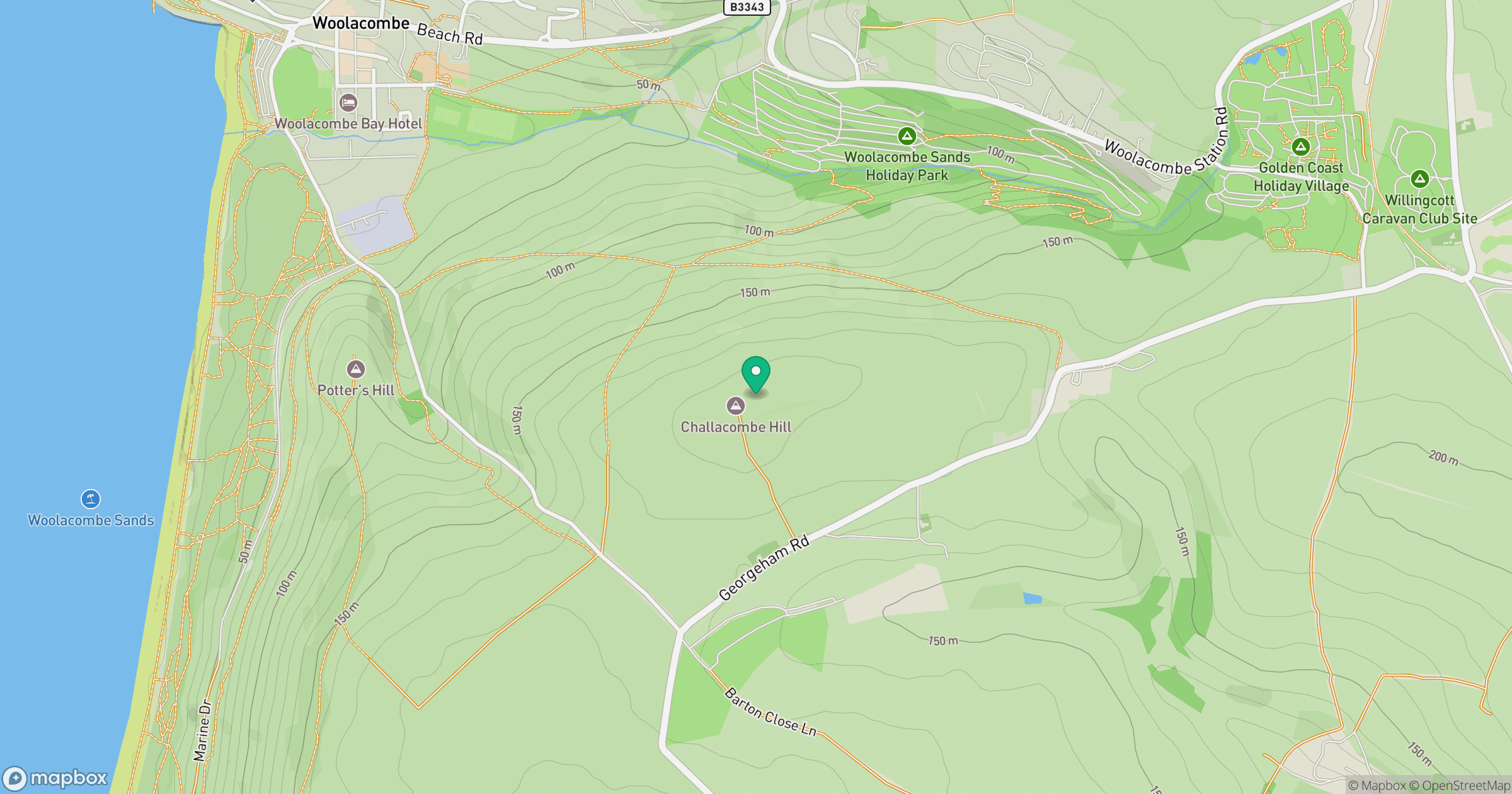
Grid reference: SS468429
View on OpenStreetMapOpens a map in a new tab, centred on the hill.
Nearby Hills
Rhossili Down - The Beacon
193m

High Willhays
622m

Brent Tor
334m

Dunkery Beacon
520m
Brown Willy
420m
No comments yet. Be the first.