
Derryvour Hill
Good walks are even better shared.
Overview
Derryvour Hill
Derryvour Hill, standing proudly at 686 meters, is a hidden gem nestled in the stunning landscape of County Tipperary, Ireland. Though not as well-known as some of its bigger siblings, it offers a delightful hike for those willing to venture into its uplands.
Geology
Derryvour is primarily characterized by its schist and granite formations, providing a geologic story that stretches back eons. It's like nature's own history book that you can hike through. As you ascend, take a moment to ponder the tectonic forces that shaped these ancient rocks — it's quite a conversation starter!
Routes and Access
The most popular route is the Derryvour Hill Trail, a moderately challenging ascent about 6.5 km in length. Most hikers complete this trail in roughly 2.5 hours, depending on pace and pit stops for photos. To get here, park at the small car park off the N65, which serves as the main access point.
For those arriving by public transport, the quaint village of Portroe is the nearest bus stop, but don’t forget to check local schedules as they can be a bit on the scarce side.
Summit Features
Upon reaching the summit, you're greeted by a stone cairn that's ready for you to appreciate the incredible panoramas. It's the perfect spot for a well-earned snack and a moment of reflection — after all, what’s the point of hiking if you can’t enjoy a good biscuit with a view!
Terrain and Hazards
The terrain can be a jumble of grassy slopes and rocky outcrops, with a few boggy sections that may challenge the clumsy. Watch your footing, especially if the weather’s been wet!
Hazards include slippery paths and the youngest hikers should be briefed on local wildlife such as ticks during warmer months.
Views
Once you’ve caught your breath and stocked up on snacks, the views are spectacular! Gaze across Lough Derg or take in the majestic Slieve Bernagh mountains to the west — a sight for sore eyes (and legs).
Conclusion
Derryvour Hill is a charming and accessible hike for both enthusiastic explorers and casual walkers. With its varying terrain, stunning vistas, and rich history, it certainly deserves a place in your hiking repertoire. Remember your camera — you’ll want to capture the memories (and the views)!
Last Updated
Information current as of 2023-10-12.
Source
This data is sourced from the Ordnance Survey, which provides detailed geographical information for the UK.
Explore routes near Derryvour Hill
Public walks starting within 80 km of this hill. Nearby does not mean a route reaches the summit; check its map and access before setting out.
No public routes are currently listed within 80 km of Derryvour Hill on Walkmates. This does not mean there are no paths here. Explore the map and check local access information before planning a walk.
Route planning notes
These notes describe possible approaches, not verified navigable routes or permission to cross land. Check current paths, local access rules and conditions before setting out.
Derryvour Hill Trail
This is a popular circular route starting from the foothills, offering a gentle ascent with a few rocky stretches along the way. Ideal for those looking to enjoy both nature and a good stretch in their legs.
Make a day of it, together
Find someone to share the walk with, or organise a day out along a route you like.
Hill facts and local notes
Classifications
Elevation
160m
525 ft
Prominence
131m
Coordinates
51.7263, -9.9560
V649544
OS Map
84
At the Summit
At the summit, you'll find a modest stone cairn which offers a welcoming sight for those who have made the climb. There's also a flattened rock area that's great for picnicking and soaking in the views — just don't forget to bring your sandwiches!
Terrain & Geology
Derryvour Hill is primarily composed of schist and granite rock formations, which offers a unique glimpse into the geological history of the region. The craggy outcrops reveal layers formed over millions of years, providing an excellent opportunity for geology enthusiasts to contemplate the beauty of nature's handiwork.
Views & Scenery
On a clear day, the views extend over Lough Derg and the surrounding hills, including the picturesque Shannon river winding its way through the landscape. Look out for the majestic Slieve Bernagh mountains to the west.
History & Heritage
Name Origin
The name 'Derryvour' is derived from the Irish 'Doire Bhuir', meaning 'the oak grove of the branch', hinting at the area's lush flora.
Historical Significance
Like many peaks in the region, Derryvour Hill holds cultural significance in local folklore and was a popular gathering place in past centuries for community events and celebrations.
Getting There & Facilities
Check current local access restrictions, parking rules and transport timetables before travelling. These notes do not confirm public access to the summit.
Parking
There is a small car park at the main trailhead on the N65, suitable for 10-15 vehicles. Be mindful of local parking regulations.
Public Transport
The nearest bus stop is in the village of Portroe, about 5 km away, with limited services available. Check local timetables for the latest information.
Nearby Facilities
While there are no facilities directly on the hill, Nenagh has several cafes, restaurants, and public toilets for refreshment and comfort after your trek.
Safety Information
Known Hazards
- Slippery paths, especially after rain; sudden weather changes; and potential wildlife encounters, including ticks in the warmer months.
General Safety Tips
- Check weather conditions before setting out
- Carry appropriate clothing and equipment
- Let someone know your planned route
- Take a map, compass, and GPS device
- Carry emergency supplies: food, water, first aid kit, torch
Hills
Some common questions about the hills answered
Are there group walks up Derryvour Hill?
Many walkers use Walkmates to join or organise walks with others. You can check for group walks around Derryvour Hill through the maps
Are there other walkers around Derryvour Hill?
Activity varies by location and time, but Walkmates lets you see whether others have shared walks or shown interest in this area. Find other people through the walking friends search walking friends for Derryvour Hill search or of course create your own walk for Derryvour Hill
Can I organise a walk to Derryvour Hill?
Yes. If there aren’t any walks listed already, you can create a walk and make it available for others to join.
If you're signed up to Walkmates, you can create a walk to Derryvour Hill.
How do I find a walk up this hill?
There are often multiple ways to walk this hill, depending on experience and route preference. Walkmates helps you explore walks and routes that others have shared.
Can I suggest a new route up Derryvour Hill?
Yes. You can suggest or create routes to share with others. Walkmates focuses on the social side of walking, so routes are used to help people organise walks and explore areas together, rather than as detailed navigation tools or route libraries.
Other uses really appreciate knowledgeable walkers sharing their routes. Share your favourite route to Derryvour Hill here
The is an error or something incorrect about this hill. How do I let you know?
We always strive to keep the information on Walkmates as accurate as possible. If you find an error, please let us know through the contact form and we'll aim to correct it as quickly as possible
Community Discussion
Comments
Location
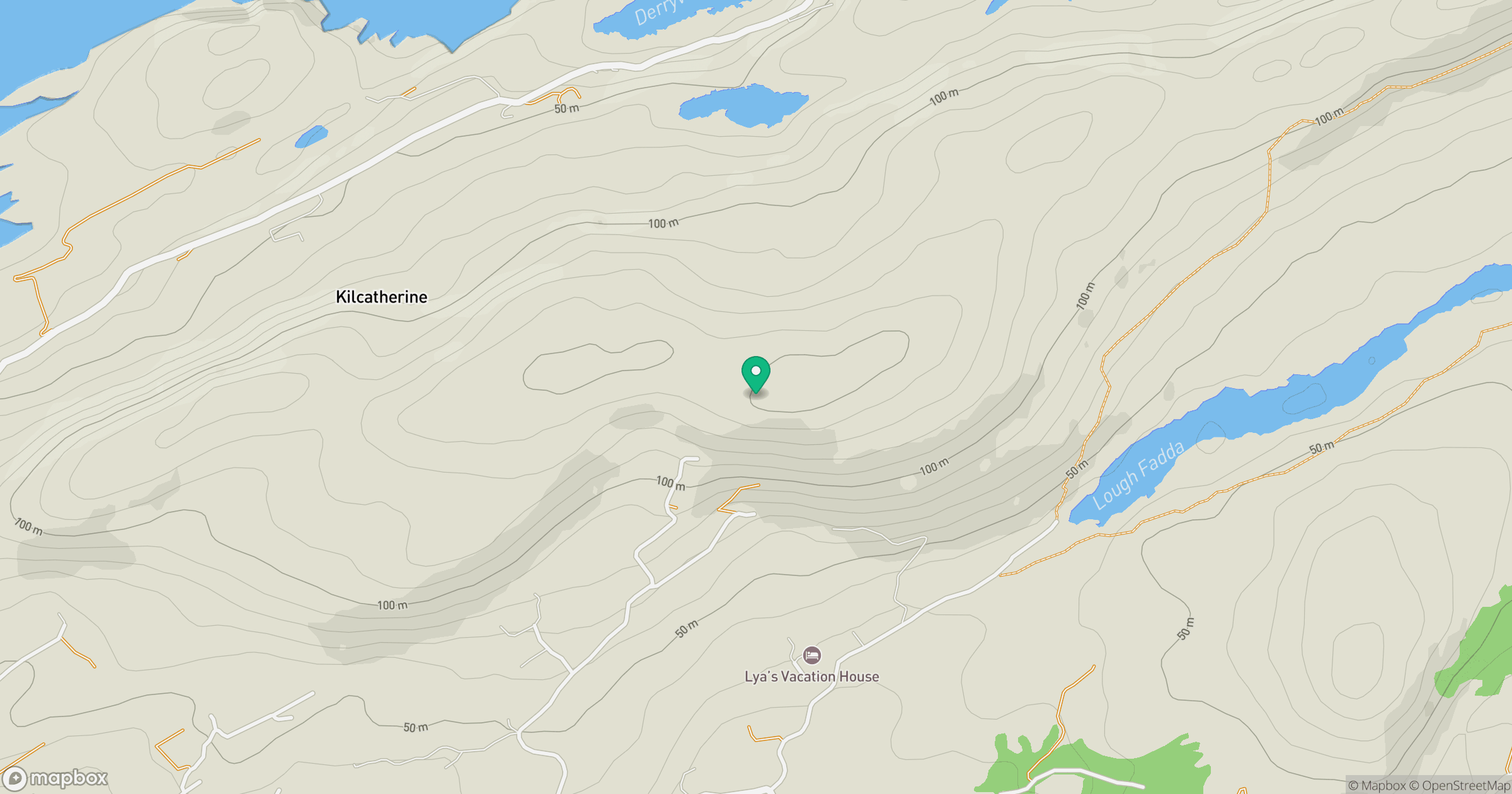
Grid reference: V649544
View on OpenStreetMapOpens a map in a new tab, centred on the hill.
Hills within 30 km
Straight-line distance, not a walking route or confirmation of access.
No comments yet. Be the first.