
Binn Chaonaigh
Good walks are even better shared.
Overview
Binn Chaonaigh Hiking Guide
Overview
Binn Chaonaigh is an impressive peak located in the Twelve Bens mountain range of Connemara, with an elevation of 791 meters. This Marilyn offers stunning panoramic views and a rewarding climb for outdoor enthusiasts.
Geology
The geology of Binn Chaonaigh is largely characterised by granite rock, formed through volcanic processes that shaped the landscape over millennia. It features striking cliffs and craggy ridges that are perfect for a challenging hiking experience, while providing geologists with an exciting area to study.
Routes
The most popular route starts at Glencroft, covering approximately 7.5 km round trip. While it’s a challenging hike that should not be underestimated, the spectacular vistas along the way provide ample motivation to reach the summit. The ascent can be steep, but rest assured that the fabulous views will be worth every step!
Terrain
Expect a range of terrains including rocky paths, grassy patches and muddy spots, particularly near the summit where rain can lead to slippery conditions. Proper footwear is essential.
Views
Upon reaching the summit, hikers are treated to breathtaking views of the Twelve Bens and Lough Nafooey. Each season offers a unique vista; spring and autumn provide clarity, whilst winter blankets the landscape in snow, creating a fairytale-like scenery.
Hazards
As with many mountainous terrains, be cautious of slips on rocky paths, especially in wet conditions. Weather can change rapidly, so be prepared for all possibilities! Wildlife is an added charm of the mountain, but remember to respect their space.
Access
To access Binn Chaonaigh, park at Glencroft where space is limited but adequate. Public transport options may require a little creativity, as Clifden is the nearest hub for services.
Facilities
Once you've conquered the mountain, reward yourself in Clifden where cafés abound, serving delicious snacks and hot beverages to refuel after your outdoor adventure.
History
The name Binn Chaonaigh means ‘The Peak of the Wren’, a nod to one of the more common birds in the area. This mountain stands not just as a natural feature, but also as a storied landmark cradling the lore and history of ancient Irish culture.
Conclusion
Binn Chaonaigh is a hidden gem in the heart of Connemara, offering exhilarating hikes, stunning views, and a touch of history. Whether you’re a seasoned hiker or a keen nature lover, a visit to Binn Chaonaigh should be on your list!
Happy hiking!
Explore routes near Binn Chaonaigh
Public walks starting within 80 km of this hill. Nearby does not mean a route reaches the summit; check its map and access before setting out.
No public routes are currently listed within 80 km of Binn Chaonaigh on Walkmates. This does not mean there are no paths here. Explore the map and check local access information before planning a walk.
Route planning notes
These notes describe possible approaches, not verified navigable routes or permission to cross land. Check current paths, local access rules and conditions before setting out.
Glencroft Path
This route begins at the foothills near Glencroft and winds steeply up towards the summit, offering spectacular views of the Connemara landscape.
Make a day of it, together
Find someone to share the walk with, or organise a day out along a route you like.
Hill facts and local notes
Classifications
Elevation
634m
2,078 ft
Prominence
111m
Coordinates
53.5027, -9.6580
L900515
OS Map
37
At the Summit
The summit features a prominent cairn, which serves as a great photo opportunity. A trig point is also located slightly to the east, providing additional landmark for navigators.
Terrain & Geology
Binn Chaonaigh is composed primarily of granite, with ancient volcanic rock formations giving the area a rugged appearance. The mountain boasts steep cliffs and sharp ridges that are geologically interesting and offer an opportunity to observe the distinct stratigraphy of the region.
Views & Scenery
From the summit, hikers can take in stunning views of the surrounding Twelve Bens mountain range, Lough Nafooey, and the Atlantic coastline in the distance.
History & Heritage
Name Origin
Binn Chaonaigh translates from Irish to 'The Peak of the Wren,' possibly referring to the bird's presence in the region.
Historical Significance
Historically, the area is significant for its ancient Gaelic culture and mythology, with stories of the Tuatha Dé Danann being linked to the mountains of Connemara.
Getting There & Facilities
Check current local access restrictions, parking rules and transport timetables before travelling. These notes do not confirm public access to the summit.
Parking
The nearest parking area is at Glencroft, where there is limited space but ample room for a few vehicles. Always park considerately.
Public Transport
There are no direct public transport services to Glencroft, but nearby villages such as Recess offer bus services from Galway, with taxis available for the short distance to the start point.
Nearby Facilities
Clifden offers several cafes, shops, and public toilets. There's nothing like a cup of tea and a slice of cake post-hike to soothe those weary legs!
Safety Information
Known Hazards
- Rugged terrain presenting a risk of slips, especially in wet conditions. Weather can change rapidly, leading to fog and reduced visibility. Wildlife is also present, so keep a respectful distance.
General Safety Tips
- Check weather conditions before setting out
- Carry appropriate clothing and equipment
- Let someone know your planned route
- Take a map, compass, and GPS device
- Carry emergency supplies: food, water, first aid kit, torch
Hills
Some common questions about the hills answered
Are there group walks up Binn Chaonaigh?
Many walkers use Walkmates to join or organise walks with others. You can check for group walks around Binn Chaonaigh through the maps
Are there other walkers around Binn Chaonaigh?
Activity varies by location and time, but Walkmates lets you see whether others have shared walks or shown interest in this area. Find other people through the walking friends search walking friends for Binn Chaonaigh search or of course create your own walk for Binn Chaonaigh
Can I organise a walk to Binn Chaonaigh?
Yes. If there aren’t any walks listed already, you can create a walk and make it available for others to join.
If you're signed up to Walkmates, you can create a walk to Binn Chaonaigh.
How do I find a walk up this hill?
There are often multiple ways to walk this hill, depending on experience and route preference. Walkmates helps you explore walks and routes that others have shared.
Can I suggest a new route up Binn Chaonaigh?
Yes. You can suggest or create routes to share with others. Walkmates focuses on the social side of walking, so routes are used to help people organise walks and explore areas together, rather than as detailed navigation tools or route libraries.
Other uses really appreciate knowledgeable walkers sharing their routes. Share your favourite route to Binn Chaonaigh here
The is an error or something incorrect about this hill. How do I let you know?
We always strive to keep the information on Walkmates as accurate as possible. If you find an error, please let us know through the contact form and we'll aim to correct it as quickly as possible
Community Discussion
Comments
Location
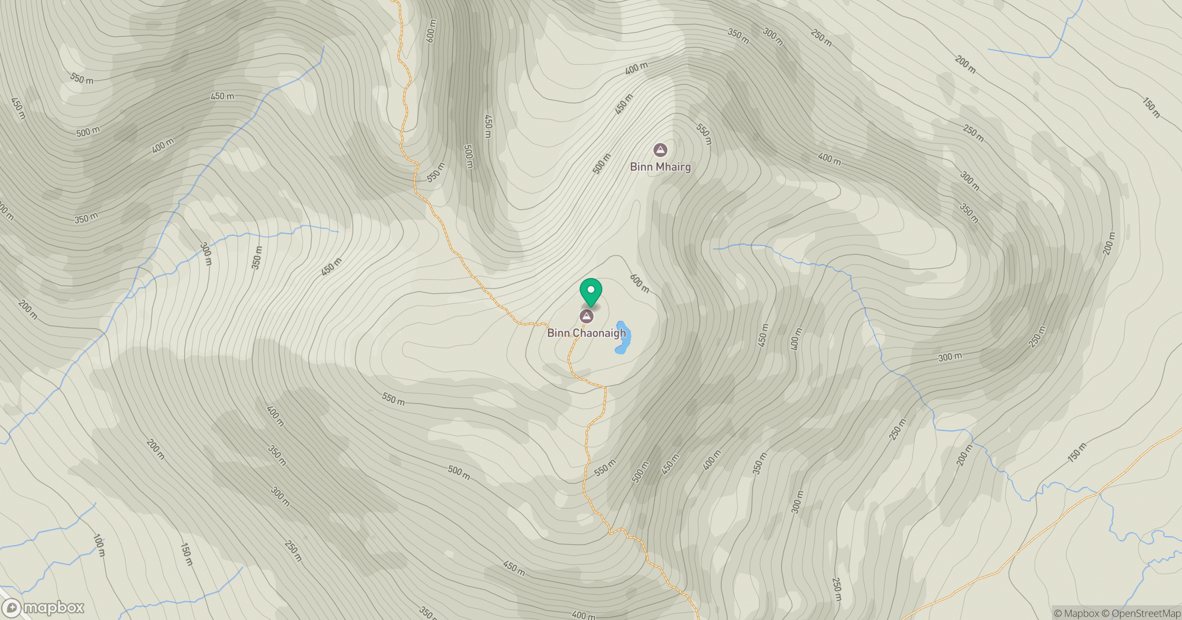
Grid reference: L900515
View on OpenStreetMapOpens a map in a new tab, centred on the hill.
Hills within 30 km
Straight-line distance, not a walking route or confirmation of access.
Mweelrea
814m
Croagh Patrick
764m
Barrslievenaroy [Mulnahogue]
702m
Binn Mhor
661m
Cnoc na hUilleann [Knocknahillion]
605m
No comments yet. Be the first.